Heavy Rains In SE NM Wednesday, June 1, 2022.
Looking East At A Hail Core.
Hobbs Hwy East Of The St Rd 176 Cutoff.
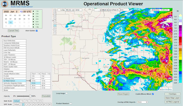
(As Of 6 AM MDT Thursday, June 2, 2022).
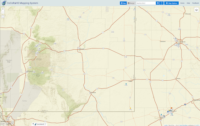
(As Of 6 AM MDT Thursday, June 2, 2022).
(As Of 8 AM MDT Thursday, June 2, 2022).
Hail Near Andrews, Texas.
Courtesy of Mike Olbinski
Jal, NM Supercell.
Courtesy of Texas Storm Chasers.
Scattered thunderstorms developed rapidly Thursday afternoon east of Artesia and Carlsbad. They quickly became severe and eventually congealed into a large complex of thunderstorms (MCS-Mesoscale Convective System) that moved east and southeast into West Texas.
Heavy rains from these thunderstorms fell mainly in central and southern Lea County west of Hobbs, Monument, Eunice, and Jal. The CoCoRaHS Station in Jal measured 1.45". Radar estimates were as high as 2"-3" south of Jal and west of Monument and southwest of Hobbs.
Heavy rains from these thunderstorms fell mainly in central and southern Lea County west of Hobbs, Monument, Eunice, and Jal. The CoCoRaHS Station in Jal measured 1.45". Radar estimates were as high as 2"-3" south of Jal and west of Monument and southwest of Hobbs.
Another chase opportunity presented itself so I left Carlsbad around 3:30 PM MDT and headed northeast on the Hobbs Hwy towards Hobbs. I got roughly five east of the St Hwy 176 turn off and ran into the back edge of a severe warned thunderstorm ahead and northeast of me. That's when I grabbed my Nikon camera and snapped the cover photo above. That hail core looked like it was more than I wanted to tangle with so I stopped, turned around, and headed back down 176 towards Eunice.
I encountered penny-size hail and measured a thunderstorm outflow gust of 53 mph about 15 miles southeast from the turnoff on the Hobbs highway. I kept going until I arrived in Eunice where I gassed up, grabbed a snack, then headed south towards Jal on St Hwys 207 and 18.
Seven miles north of Jal on St Hwy 18 I encountered blinding rain with near-zero visibility during a wet microburst at 5:27 PM MDT. I pulled over and clocked a peak wind gust of 67 mph from the northeast from my roof-mounted anemometer on my truck.
At 3:30 PM MDT hen egg size hail (2" in diameter) was reported 6 miles southeast of Maljamar. At 4:33 PM MDT hen egg size hail (2" in diameter) was reported 9 miles south of Frankel City, Texas in Andrews County. Storm Chaser Mike Olbinski shot a video of hail accumulating up to 6+" deep on the Hwy southwest of Andrews, Texas. Video posted above.
Heavy rain continued to fall until I arrived in Jal and turned west on St Hwy 128 to work my way back home to Carlsbad. I ran into some dime-size hail and periods of heavy rain at times but overall it was a rather uneventful chase. I needed to be ahead of the storms and that just didn't happen. It was nice to ride along in the rain and cool temps (67º) however.
There Are None So Blind As Those Who "Will - Not" To See...107.


Comments
Post a Comment
Your comments, questions, and feedback on this post/web page are welcome.