

6-22-2022 Rainfall Summary - Weekly Totals & Month-To-Date Totals.

West Of Brantley Lake.
Looking West On St Hwy 137.
(June 16 - 22, 2022).


CoCoRaHS June 2022 Rainfall Totals.
(June 1 - 22, 2022).


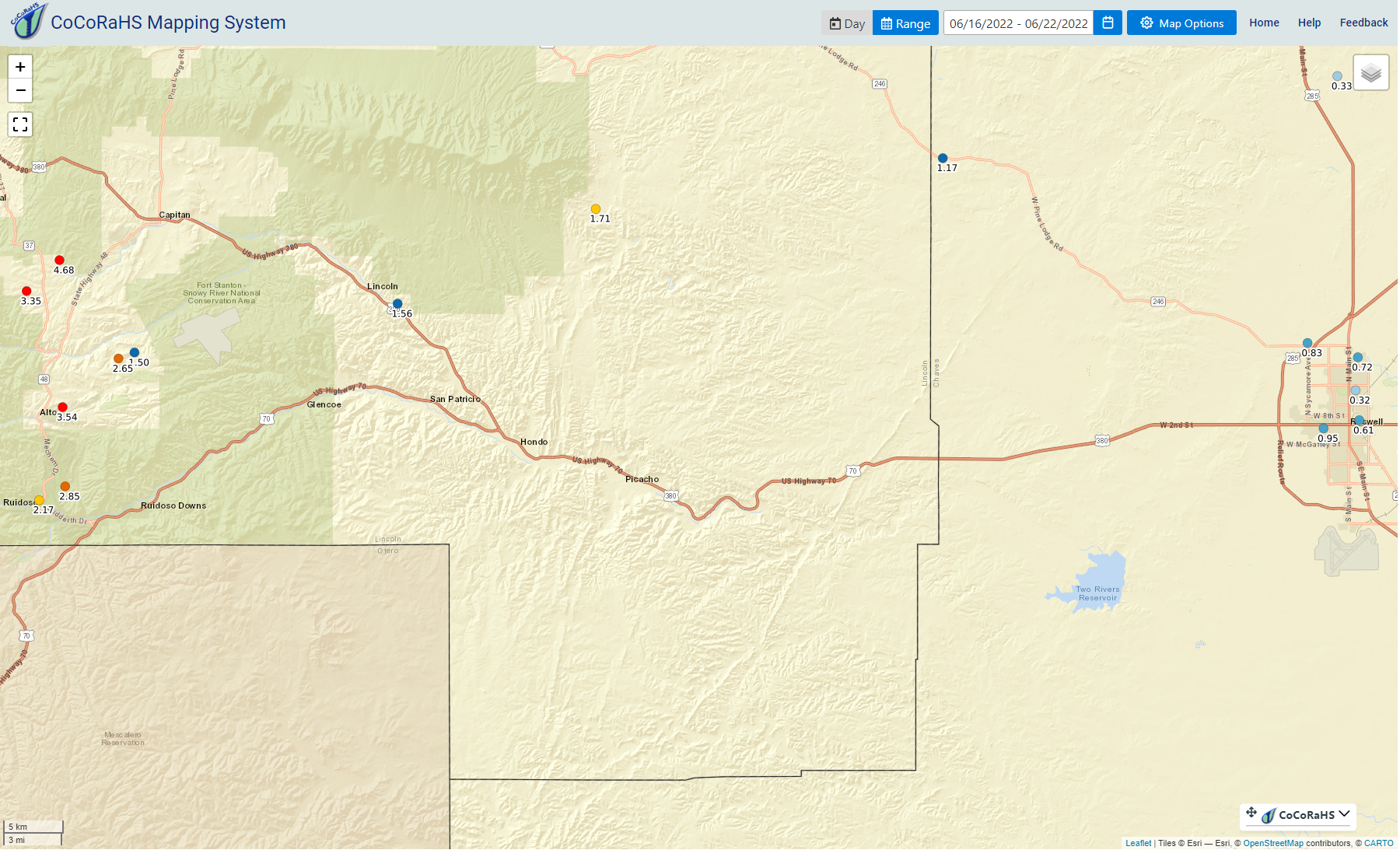
(June 16 - 22, 2022).


7-Day & 30-Day Totals).


5-Day Totals.
(As Of 6 AM MDT Wednesday, June 22, 2022)

7-Day Totals.
(As Of 6 AM MDT Wednesday, June 22, 2022)

30-Day Totals.
(As Of 6 AM MDT Wednesday, June 22, 2022)

(As Of 9 AM MDT Wednesday, June 22, 2022).
Ruidoso 1.4 SSW 2.85" 2.95"
Wimsatt PWS - Roachshack 3.52" 8.16"
Cox Canyon PWS - Ponderosa Pines 2.86" 7.71"
Wimsatt PWS - Wimsatt Cabin 2.62" 7.29"
Bell Canyon PWS 4.35" 5.30"
Bell Canyon PWS 4.35" 5.30"
Capitan 4.3 WSW 4.68" 5.08"
Cloudcroft PWS - Dalton's Mountain 1.99" 4.38"
Cloudcroft 4.0 E 4.00" 4.21"
Nogal 4.6 SSE 3.35" 3.96"
Nogal 4.6 SSE 3.35" 3.96"
Alto PWS 3.38" 3.95"
Mayhill 2.8 WNW Missing 3.86"
Mayhill PWS 3.01" 3.38"
Ruidoso 1.4 SSW 2.85" 2.95"
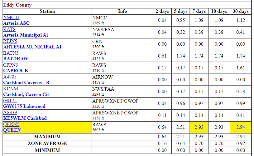
Queen Raws 2.93" 2.94"
Cloudcroft NWS Climate Co-Op Station 2.62" 2.92"
Cloudcroft NWS Climate Co-Op Station 2.62" 2.92"
Sierra Blanca Snotel 2.90" 2.90"
Sacramento Peak Observatory 2.81" 2.87"
Elk NWS Climate Co-Op Station 2.48" 2.82"
Capitan 1.3 WSW 2.40" 2.82"
Mayhill 4.0 SSE 1.59" 2.65"
Dell City PWS 1.40" 2.49"
Arabela 2.5 SSW 1.71" 2.29"
Arabela 2.5 SSW 1.71" 2.29"
Mountain Park NWS Climate Co-Op Station 1.25" 2.05"
Alamogordo 3.7 NNE 1.06" 2.01"
Ruidoso NWS Climate Co-Op Station 1.82 2.00"
Dunken Raws 1.78" 1.82"
Carlsbad Caverns - Bat Draw Raws 1.74" 1.74"
Dexter PWS - Grimmie .59" 1.70"
Paduca Raws .26" 1.64"
Paduca Raws .26" 1.64"
Roswell 5.1 N .72" 1.62"
Dog Canyon Raws 1.28" 1.54"
Roswell North PWS .83" 1.49"
Roswell North PWS .83" 1.49"
Artesia PWS - West Blevins .25" 1.48"
Artesia NWS Climate Co-Op Station 1.40" 1.45"
Artesia NWS Climate Co-Op Station 1.40" 1.45"
Lakewood PWS .97" .99"
Artesia PWS - Tortilla Flats .16" .95"
Artesia PWS - Tortilla Flats .16" .95"
Albuquerque Airport ASOS .83" .83"
Pine Springs - Guadalupe Mtn's Natl Park .82" .83"
Roswell Airport ASOS .26" .65"
Carlsbad 2.1 NNW .44" .63"
Carlsbad Airport ASOS .16" .52"
In most cases, the heaviest rains have fallen since this past Friday. The rainfall totals listed above are from a variety of sources. Official and unofficial stations such as the Personal Weather Stations (PWS). See the maps and tables above for a more complete listing of some of the reported heavier rainfall totals.
Thunderstorms are dropping heavy rain in the Ruidoso and Alto areas as of 1:00 PM MDT. The Ruidoso Far Upper Canyon PWS has already measured 1.70" of rain today. The Ruidoso Four Cabins PWS has already measured 1.21", and the Alto PWS has already measured 1.10" of rain.
Scattered daily rounds of thunderstorms remain in the forecast for the Sacramento mountains today through the first of next week. Some of these will produce heavy to very heavy rainfall and localized flash flooding at times.
There Are None So Blind As Those Who "Will - Not" To See...107.


Comments
Post a Comment
Your comments, questions, and feedback on this post/web page are welcome.