Why Are My Weather Posts Missing From Facebook.

Hello everyone. I just wanted to let you know that my Facebook page was shut down without any warning by Facebook this past Saturday, June 8th. All I was told was that I had violated their community standards. I don't know what triggered that; they didn't tell me. I was told this may be permanent or for six months.
My guess is that it may be because I posted several comments and articles from my Substack page about the riots in LA, and that must have triggered/angered someone, and they complained, thus Facebook shut me down. I don't know this as fact, though. I have appealed this decision, and I'm still waiting for their reply. I have read on X that this has happened to other Facebook users posting about the LA riots as well.
I always share my weather blog posts (that I post here) on my Facebook page and my X page. This included over twelve different New Mexico and West Texas Facebook Community sites. So there are thousands of you out there (based on my views and shares of those posts) who will no longer see those posts. My Facebook page may or may not be restored.
This is another good reason (as the National Weather Service often reminds us) to have multiple ways of receiving severe weather alerts when severe weather threatens your location. My weather web page is one of those ways, and I really appreciate all of you who have and still do use it. Thank you so much!!!
If my Facebook page is restored, I will continue to share my weather blog posts and some of the NWS Watches and Warnings...as I have been doing for years now.

February 12-19, 2021 Historic Winter Storm Summary #1.


4:04 AM MST.
Monday, Feb15, 2021.

(4 AM MST Monday, Feb 15, 2021).


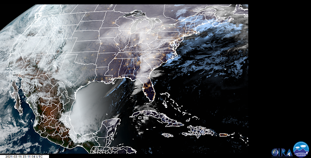
Brutal Cold Plunges Into The Gulf Of Mexico.

Take a close look at the Geo Color Satellite image at the top of the page. Notice that status clouds had covered nearly the entire Gulf of Mexico as the brutal polar airmass plunged deep into the Gulf. Temperatures at 4 AM MST had fallen below freezing with apparent temperatures down into the upper teens! I would have loved to have been aboard a commercial airliner flying over this cloud deck at 35,000' and looking down on it. That would have been a beautiful sight to behold for sure. 

This Weeklong Event Was Historic. 

It is going to take awhile for all of the records that were smashed by this historic long-duration polar outbreak to be complied. Widespread record cold sent the region into the deep freeze for more than a week in many nearby areas. Although most locations in Texas did not break the "Coldest Night In Texas" all-time record lows set back on February 12, 1899...some did and others were close. Midland rose above freezing for the first time today in the past 91/2 days. Just incredible.

Thankfully in New Mexico, we did not get nearly as cold as the brutal Polar outbreak of February 2011. Or January 1962 and February 8, 1933. Years with low temperatures below 0ºF in Southeastern New Mexico. This Polar invasion was bad but not nearly as bad as years past. 

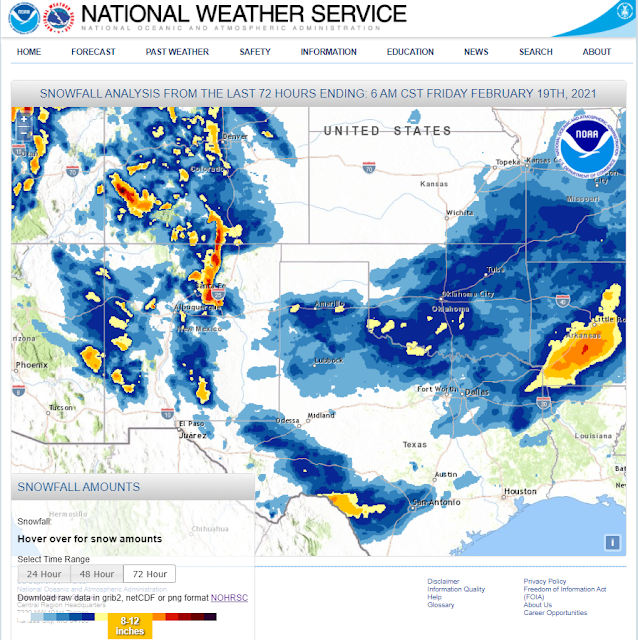
Not only was the cold remarkable (especially the duration and many days in a row below freezing) so was the snowfall in Texas. In New Mexico not so much. It's been much colder in New Mexico including Southeastern New Mexico. Our local storm total snowfall totals came nowhere close to the Blizzard of December 2015 but our snow did add to the misery. More on this later when the data becomes available.

(As Of 5 AM MST Friday, Feb 19, 2021).


National Snow Depth Coverage Map.
(At 6 AM MST Friday, Feb 19, 2021).


(Storm Snowfall Totals Of 6" and Greater).
(Feb 12 -19, 2021).


(Feb 12 -19, 2021).


Texas CoCoRaHS Reported Snowfall Totals.
(Storm Snowfall Totals Of 6" and Greater).
(Feb 12 -19, 2021).


• 11 ENE RED RIVER - 17.0 in.

 • 1 N SANTA FE - 14.5 in.
 •  SANTA FE - 14.3 in.
 • 8 SE EAGLE NEST - 14.0 in.
 • 11 ENE AMALIA - 14.0 in.
 • 7 ESE CHUPADERO - 14.0 in.
 • 5 SSE SANTA FE - 13.3 in.
 • 3 SW SANTA FE - 13.0 in.
 • 5 SSE LLANO LARGO - 13.0 in.
 • 6 SSE SANTA FE - 12.8 in.
 • 1 E SANTA FE - 12.2 in.
 •  PIETOWN - 12.1 in.
 • 8 SSW RED RIVER - 12.0 in.
 • 2 NE SANTA FE - 12.0 in.

 • 9 ENE SHADY BROOK - 11.0 in.
 • 2 W CAPITAN - 11.0 in.
 • 5 SSW TOADLENA - 11.0 in.
 • 1 W PONDEROSA - 11.0 in.
 • 2 E SAN PABLO - 10.3 in.
 • 2 SW SANTA FE - 10.0 in.
 • 8 SW ROCIADA - 10.0 in.
 • 2 SE SANTA FE - 10.0 in.
 • 5 SE SANTA FE - 10.0 in.
 • 1 WSW SANTA FE - 10.0 in.

 • 6 SSE SANTA FE - 9.8 in.
 • 1 N SANTA FE - 9.0 in.
 • 3 NW TRES RITOS - 9.0 in.
 •  TRES RITOS - 9.0 in.
 • 3 N SANTA FE - 9.0 in.
 • 8 NE ARROYO SECO - 9.0 in.
 • 7 ESE CUBA - 9.0 in.

 •  TESUQUE - 8.0 in.
 • 1 SE SANTA FE - 8.0 in.
 • 3 NNW LAMY - 8.0 in.
 •  SANTA FE - 8.0 in.
 • 8 NNW GLORIETA - 8.0 in.
 • 2 SW PECOS - 8.0 in.
 • 9 E CUBA - 8.0 in.
 •  VALDEZ - 8.0 in.

 • 1 N AGUA FRIA - 7.7 in.
 •  TAOS - 7.5 in.
 •  ANGEL FIRE - 7.5 in.
 • 4 SW SANTA FE - 7.5 in.
 • 4 N AGUA FRIA - 7.4 in.
 • 5 NE ALTO - 7.3 in.
 • 4 NNW LAMY - 7.2 in.
 • 5 ESE BLACK LAKE - 7.2 in.
 • 5 E EL MORRO - 7.0 in.
 • 3 ESE ANGEL FIRE - 7.0 in.
 • 1 NW OCATE - 7.0 in.
 • 5 SW BONITO LAKE - 7.0 in.
 • 4 NNW TRES RITOS - 7.0 in.
 • 3 NE RUIDOSO - 7.0 in.
 • 5 E SHADY BROOK - 7.0 in.
 • 13 ESE CUBA - 7.0 in.
 • 3 WNW SANTA FE - 7.0 in.

 •  SANTA FE - 6.5 in.
 • 2 NW RIBERA - 6.3 in.
 • 4 NW SANTA FE - 6.2 in.
 • 5 NW CANONES - 6.1 in.
 •  LAMY - 6.0 in.
 • 3 ENE PONDEROSA - 6.0 in.
 • 1 NE BLOOMFIELD - 6.0 in.
 •  RED RIVER - 6.0 in.
 • 3 SW LLANO - 6.0 in.
 • 1 NNW CEDAR CREST - 6.0 in.
 • 2 WSW EL MORRO - 6.0 in.

 • 2 ENE TAOS - 5.9 in.
 • 3 NNW LAMY - 5.8 in.
 • 5 ESE BLACK LAKE - 5.8 in.
 •  SANDIA PARK - 5.8 in.
 • 3 E MEADOW LAKE - 5.8 in.
 • 2 NW CARNUEL - 5.6 in.
 • 3 NE FARMINGTON - 5.5 in.
 • 1 ESE SEDILLO - 5.5 in.
 • 2 WSW HERNANDEZ - 5.5 in.
 • 2 NNE ROWE - 5.5 in.
 •  JACONITA - 5.5 in.
 • 1 E AZTEC - 5.3 in.
 • 12 SSW VERMEJO PARK - 5.2 in.
 • 2 SSW LOS CORDOVAS - 5.1 in.
 • 2 W PONDEROSA - 5.1 in.
 • 4 W MOUNTAINAIR - 5.0 in.
 • 28 WNW RATON CREWS AIRPORT - 5.0 in.
 • 12 SSE COYOTE - 5.0 in.
 •  AZTEC - 5.0 in.
 • 2 SE AGUA FRIA - 5.0 in.
 •  POJOAQUE - 5.0 in.
 • 7 E CANJILON - 5.0 in.
 •  BLOOMFIELD - 5.0 in.
 • 1 ESE AZTEC - 5.0 in.
 • 6 W LOS ALAMOS - 5.0 in.
 • 6 SSE LUNA - 5.0 in.
 •  EAGLE NEST - 5.0 in.

 • 5 NW LAMY - 4.9 in.
 • 4 SSW FLORA VISTA - 4.5 in.
 • 1 N RUIDOSO - 4.5 in.
 • 2 NNE ESPANOLA - 4.5 in.
 • 1 N CANONES - 4.5 in.
 • 3 NW CARNUEL - 4.5 in.
 • 1 WNW RED RIVER - 4.5 in.
 • 2 SE MANZANO - 4.5 in.
 • 1 ESE TRUCHAS - 4.4 in.
 • 2 W DATIL - 4.3 in.
 • 4 NW LAMY - 4.3 in.
 • 1 ESE POJOAQUE PUEBLO - 4.0 in.
 • 4 NW SANDIA PARK - 4.0 in.
 • 6 NNW CARNUEL - 4.0 in.
 • 2 E GLORIETA - 4.0 in.
 • 5 E AZTEC - 4.0 in.
 •  CROWNPOINT - 4.0 in.
 • 3 NNE LOS CERRILLOS - 4.0 in.
 •  FARMINGTON - 4.0 in.
 • 1 NE AGUA FRIA - 4.0 in.
 • 2 SE ALTO - 4.0 in.
 • 1 WSW PONDEROSA - 4.0 in.

 • 7 WNW CANONCITO - 3.7 in.
 • 1 WSW FARMINGTON - 3.6 in.
 • 1 S CEDAR HILL - 3.6 in.
 • 9 NE ALBUQUERQUE - 3.5 in.
 • 5 WSW ARROYO HONDO - 3.5 in.
 • 1 WSW SEDILLO - 3.5 in.
 • 3 NE BONITO LAKE - 3.5 in.
 • 3 SSW FARMINGTON - 3.5 in.
 •  CHAMA - 3.5 in.
 • 1 WNW EL RANCHO - 3.5 in.
 • 15 NW ALBUQUERQUE - 3.5 in.
 • 1 S SEDILLO - 3.5 in.
 • 1 WSW LOS ALAMOS - 3.5 in.
 • 3 SSE MAGDALENA - 3.4 in.
 • 2 SW MIERA - 3.4 in.
 • 1 SW GALLUP - 3.3 in.
 • 1 WNW LAMY - 3.1 in.
 • 2 WNW MINERAL HILL - 3.0 in.
 • 8 SSW SAN MIGUEL - 3.0 in.
 • 3 E LOS ALAMOS - 3.0 in.
 • 3 S FARMINGTON - 3.0 in.
 • 6 NW CARNUEL - 3.0 in.
 • 2 NE SAN ANTONITO - 3.0 in.
 • 1 SSE SEDILLO - 3.0 in.
 •  CANJILON - 3.0 in.
 • 5 WNW LOS ALAMOS - 3.0 in.
 • 4 W MOUNTAINAIR - 3.0 in.
 • 6 ENE ALBUQUERQUE - 3.0 in.
 • 1 ENE SANTA CRUZ - 3.0 in.

 • 1 ENE ALTO - 2.8 in.
 • 4 NW CARNUEL - 2.8 in.
 • 2 NE CHACON - 2.6 in.
 • 1 N MORIARTY - 2.6 in.
 • 5 NNW CARNUEL - 2.6 in.
 • 1 WNW WHITE ROCK - 2.6 in.
 • 5 ENE SANTA CRUZ - 2.5 in.
 • 3 ENE SANTA FE - 2.5 in.
 • 2 ENE GALLUP - 2.5 in.
 • 4 NE SANTA FE - 2.5 in.
 • 2 SE SOUTH SAN YSIDRO - 2.5 in.
 • 8 ESE ALBUQUERQUE - 2.5 in.
 • 4 SSE ALBUQUERQUE - 2.5 in.
 • 8 E ALBUQUERQUE - 2.5 in.
 •  RIO COMMUNITIES - 2.5 in.
 • 5 ENE LOS CERRILLOS - 2.4 in.
 • 3 N CHILILI - 2.4 in.
 • 1 ESE CEDAR HILL - 2.3 in.
 • 2 S VALENCIA - 2.3 in.
 • 1 SSE GALLUP - 2.3 in.
 • 1 N RATON - 2.3 in.
 • 6 SSE SANTA FE - 2.3 in.
 • 1 E VALENCIA - 2.1 in.
 • 6 SE RIO COMMUNITIES - 2.1 in.
 • 5 NE ALBUQUERQUE - 2.0 in.
 • 6 WNW TERERRO - 2.0 in.
 • 2 W ANGUS - 2.0 in.
 •  GALLUP - 2.0 in.
 • 2 NW EDGEWOOD - 2.0 in.
 • 2 NE PLACITAS - 2.0 in.
 • 5 E ALBUQUERQUE - 2.0 in.
 • 8 NNW CARNUEL - 2.0 in.
 • 1 S SANTA FE - 2.0 in.
 • 6 ESE MOGOLLON - 2.0 in.
 • 1 SSW MADRID - 2.0 in.
 • 2 E SAN ANTONITO - 2.0 in.
 • 3 WSW CARNUEL - 2.0 in.
 • 11 NNW CANON PLAZA - 2.0 in.

 • 5 W CARNUEL - 1.8 in.
 • 2 SSW VALENCIA - 1.8 in.
 •  SAN ANTONIO - 1.8 in.
 • 5 E ALBUQUERQUE - 1.8 in.
 • 1 S PERALTA - 1.7 in.
 • 3 ESE ALBUQUERQUE - 1.6 in.
 • 2 SE ALBUQUERQUE - 1.5 in.
 • 7 ESE KENNA - 1.5 in.
 • 8 W MCINTOSH - 1.5 in.
 • 3 ESE MIERA - 1.5 in.
 • 5 NNW CARNUEL - 1.5 in.
 • 1 E SOCORRO - 1.5 in.
 • 1 SSE WHITE ROCK - 1.5 in.
 • 1 ENE SANTA FE - 1.5 in.
 • 5 ESE ALBUQUERQUE - 1.5 in.
 •  CORDOVA - 1.5 in.
 • 1 SSW SAN ANTONIO - 1.5 in.
 • 7 NNW AGUA FRIA - 1.5 in.
 • 5 S ALBUQUERQUE - 1.4 in.
 • 2 NE SOCORRO - 1.4 in.
 • 4 W ALBUQUERQUE - 1.4 in.
 • 1 SSE ESCONDIDA - 1.4 in.
 • 4 NW ALBUQUERQUE - 1.3 in.
 • 4 S LOS CERILLOS - 1.3 in.
 • 14 NW MILAN - 1.3 in.
 • 7 W SANDIA PARK - 1.3 in.
 • 8 W SANDIA PARK - 1.3 in.
 • 2 E ALBUQUERQUE - 1.3 in.
 • 4 WSW RIO RANCHO - 1.2 in.
 • 1 NNE CORRALES - 1.2 in.
 • 3 WNW ALBUQUERQUE - 1.1 in.
 • 3 W ALBUQUERQUE - 1.1 in.
 • 12 NNW JEMEZ SPRINGS - 1.0 in.
 • 5 WNW ALBUQUERQUE - 1.0 in.
 • 2 SSW SANTA ANA PUEBLO - 1.0 in.
 •  DULCE - 1.0 in.
 • 1 SSW CHAMIZAL - 1.0 in.
 • 3 W RIO RANCHO - 1.0 in.
 • 1 SSW MORIARTY - 1.0 in.
 • 6 NW EDGEWOOD - 1.0 in.
 • 1 SSE ALBUQUERQUE - 1.0 in.
 • 1 WSW SPRINGER - 1.0 in.
 • 3 NNE ALBUQUERQUE - 1.0 in.
 • 5 NNW CARNUEL - 1.0 in.

 • 5 NW ALBUQUERQUE - 0.9 in.
 • 5 NNW ALBUQUERQUE - 0.9 in.
 • 2 NNE ROSWELL - 0.9 in.
 • 6 NNW ALBUQUERQUE - 0.9 in.
 • 1 WSW MIAMI - 0.9 in.
 • 1 W SANTA FE - 0.8 in.
 • 3 NW SANDIA PUEBLO - 0.8 in.
 • 4 NNW ISLETA PUEBLO - 0.8 in.
 • 3 SW RIO RANCHO - 0.8 in.
 • 1 SW SANTA FE - 0.8 in.
 • 2 NNW EDGEWOOD - 0.8 in.
 • 1 SSW LA MADERA - 0.8 in.
 • 4 E ALBUQUERQUE - 0.8 in.
 • 4 NE ALBUQUERQUE - 0.8 in.
 • 8 NW ALBUQUERQUE - 0.8 in.
 • 5 NNW CARNUEL - 0.8 in.
 • 3 NNW ISLETA PUEBLO - 0.7 in.
 • 9 NW ALBUQUERQUE - 0.7 in.
 • 1 W GRANTS - 0.7 in.
 • 3 WSW CORRALES - 0.7 in.
 • 8 WNW ALBUQUERQUE - 0.7 in.
 • 6 NNW ROSWELL - 0.7 in.
 • 5 N ALBUQUERQUE - 0.7 in.
 • 1 E RIO RANCHO - 0.7 in.
 • 1 ENE RIO RANCHO - 0.6 in.
 • 1 WSW AGUA FRIA - 0.5 in.
 • 1 NNW PLACITAS - 0.5 in.
 • 3 WNW BERNALILLO - 0.5 in.
 • 5 WNW BERNALILLO - 0.5 in.
 • 1 ENE CORRALES - 0.5 in.
 • 6 NNW ALBUQUERQUE - 0.5 in.
 • 6 NW ALBUQUERQUE - 0.5 in.
 • 4 WNW RIO RANCHO - 0.5 in.
 • 2 SSW RUIDOSO - 0.4 in.
 • 1 WSW BERNALILLO - 0.4 in.
 • 3 N MILAN - 0.4 in.
 • 2 NW EL RITO - 0.4 in.
 • 5 W ALBUQUERQUE - 0.3 in.
 • 1 NW CORRALES - 0.3 in.
 • 2 SSW ARABELA - 0.2 in.
 • 2 SSE PERALTA - 0.2 in.
 • 2 WNW CLOVIS - 0.2 in.
Last updated:
0110 PM 02/18/20

The Truth Is Stranger Than Fiction!
Comments

NWS Albuquerque Burn Scar Matrix

Current National Weather Service Watches/Warnings In Effect.

New Mexico

Chaves County Plains & Mtn's

Eddy County

Culberson County

Lea County

Lincoln County

Otero County

Current US Temps

Current US Wind Chill/Heat Index Temperatures

WPC 7-Day Precipitation Forecast

Roswell Live EarthCam

Ruidoso Live Webcam

Cloudcroft Live Webcam

NWS Midland 3-Day Precipitation Forecast

NWS Midland 3-Precipitation Chances

New Mexico 3-Day Precipitation Forecast

New Mexico Precipitation Chances

NWS El Paso 3-Day Precipitation Forecast

NWS El Paso Precipitation Chances

US 24-Hour Precipitation Forecast

US 3-Day Precipitation Forecast