My Current Weather

Thursday, February 28, 2013

Next Big Storm In About A Week.
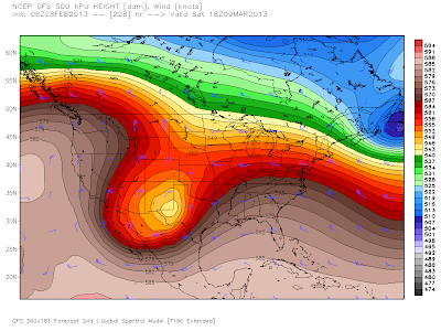
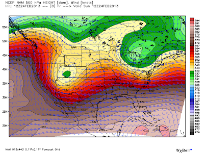

Valid At 11 AM MST, Saturday, March 9, 2013

Valid At 5 PM MST, Saturday, March 9, 2013. 

Our next potential significant storm is forecast to arrive in about a week. Until then not much is eexpected to be going on with our local weather. It will be cool again today and tomorrow with highs in the 50's. Saturday should see the 60's, and check out Carlsbad's forecast for Sunday, 82F. 
The Truth Is Stranger Than Fiction!

 My Web Page Is Best Viewed With Google Chrome.

Wednesday, February 27, 2013

Setting Moon Over C-Hill In Carlsbad, NM.


Sometimes you just get lucky, and are in the right place, at the right time, like I did yesterday morning. I wonder how many people in Carlsbad, NM were lucky enough to catch this view?

The Truth Is Stranger Than Fiction! 

 My Web Page Is Best Viewed With Google Chrome.

Tuesday, February 26, 2013

Aftermath Of Yesterday's Historic Blizzard Across Eastern NM & W TX. .


Southeastern New Mexico experienced a variety of weather from yesterday's historic blizzard that raked eastern New Mexico and west Texas with high winds, heavy snow, and deep snow drifts. Roswell picked up 1" of snow, Ruidoso 4", Ski Apache 9", while a dusting was observed in Arteisa and Carlsbad. Areas of blowing dust and blowing sand buffeted Eddy and Lea Counties later in the day. 

Sunday, February 24, 2013

DANGEROUS WINTER STORM FOR THE EASTERN 2/3RD'S OF NM!


A Very Dangerous Winter Storm will move southeastward into southeastern New Mexico late tonight. BLIZZARD WARNINGS have been issued for eastern New Mexico. Including the Santa Rosa, Vaughn, Tucumcari, Clovis, and Portales areas. 

Powerful Winter Storm Headed Our Way...Potentially Crippling Blizzard For The Texas Panhandle!


A powerful winter storm which is located over southeastern Utah this morning, will move southeastward today into tonight, and by around midnight it is forecast by this mornings 12Z NAM model to be located near Roswell, NM. Temperatures at the 500 millibar level, or roughly at the 18,000' level last night in the core of this storm, were down to -35C. Making this the coldest winter storm of the season to affect New Mexico.

Friday, February 22, 2013

More Wind Sunday?


We've experienced several storms this winter that haven't exactly panned out the way the computer models have foretasted them too. Our storm Wednesday failed to produce the expected high winds and blowing dust, not that I'm upset about this, but its a little on the unusual side to see a bust on the winds. Generally that's a pretty easy forecast to get right.

Our next storm arrives on Sunday. If the GFS model (top map) forecast is correct, then more wind and dust for southeastern New Mexico on Sunday. If the European (middle map) model is right, still more wind and dust for us, but perhaps a little better chance for snow in the Sacramento's. 

Westerly winds may gust up to around 35 to 40 mph on Sunday, possibly higher.

Highs today are forecast to range from 56 in Roswell, to 60 in Carlsbad. Saturday will be a little warmer with highs ranging from 68 in Roswell and Carlsbad, to 65 in Hobbs

Cloudcroft is expecting a high today of 28, 38 on Saturday, and 33 on Sunday, along with a slight chance for light snow on Sunday. Ruidoso is expecting a high today of 40, 48 on Saturday, and 39 on Sunday, with a slight chance of snow.

The Truth Is Stranger Than Fiction!

 My Web Page Is Best Viewed With Google Chrome.

Thursday, February 21, 2013

Wild Day Yesterday.


Thankfully our inbound winter storm slowed down yesterday in its eastward trek across Arizona. Therefore our anticipated high winds and blowing dust failed to materizle here in southeastern New Mexico. The dust did kick up around sunset and afterwards but was not nearly as bad a what was forecast. Meanwhile a line of thunderstorms moved through Lea County, producing hail that covered the ground west of Tatum.

Wednesday, February 20, 2013

Busy Day Today. High Winds-Blowing Dust, Snow In The Mtns, Severe T-Storms.


(As Of 5 AM MST).


What a surprise the rain was last night! Not only did it rain, at least in some parts of the area, it poured. The big winner was the West Texas Mesonet Station located in Pine Springs which reported 2.03" as of 8:45 PM MST last night. Trust me I never thought that the totals listed above were going to happen that's for sure. I ended up with .21" at my home here in Carlsbad, NM. Additional rainfall totals will be available later this morning via the CoCoRaHS Network.

Tuesday, February 19, 2013

A Few T-Storms Possible Tonight - Windy & Dusty Wednesday.


Early this morning a powerful winter storm was diving into the Pacific Northwest. This storm will move rapidly southeastward today into tomorrow, and by noontime tomorrow it is forecast to be located over central Arizona. Winter Storm Watches have been issued for western and northern New Mexico. Southern and southeastern New Mexico is going to get sand blasted.

A few elevated thunderstorms will be possible tonight across parts of southeastern New Mexico as low level upslope flow from the Gulf of Mexico moves northwestward and interacts with the approaching upper-level storm from the west. Hobbs, and Carlsbad, have about a 20% chance of getting wet tonight. 

Monday, February 18, 2013

High Winds & Blowing Dust Return Wednesday.


A very active week weather-wise in on tap for the area. A powerful upper-level storm, located over the Gulf of Alaska this morning (circled in red on the NAM 500 MB map above), will dive into the Four Corners Region by around sunset Wednesday. New Mexico will get blasted by high winds, blowing dust, and snow from this storm. 

The dryline will set up near the NM/TX state line, which provide the focus for thunderstorms to fire up along and east of it. Some of these may even be severe with surface based cape values of around 1,000 j/kg, lapse rates of 8.0 to 8.5 c/km, and 0 to 6 km bulk shear values forecast to be 60 - 70 knots. 

Friday, February 15, 2013

Russian Metorite Injures As Many As 1,100 People.


Update at 3:30 PM MST- Latest reports coming in from Russia indicate that 1,100 people were injured by the meteor, mostly from flying glass broken by the sonic boom as it broke up some 18-33 miles up in the atmosphere. The meteor was estimated by Russian Scientists to be weigh ten tons, and was 49 feet wide. When it entered the earths atmosphere it was moving at a speed estimated to be around 33,000 mph. 

A meteor streaked across the skies above Russia's Ural mountains this morning, some 900 miles east of Moscow. The resulting explosion injured more than 500 people according to FOX News

 The first video shows the meteor entering the atmosphere with the explosion. The second video captures the vapor trail and sound of the explosion. The last two videos captures the sound of the explosion, and the breaking glass in the buildings, along with a couple more explosions. 

Image starting your day off with this!!!

The Truth Is Stranger Than Fiction!

 My Web Page Is Best Viewed With Google Chrome.

Tuesday, February 12, 2013

Some Light Rain & Snow Overnight.


NWS Midland Doppler Radar Estimated Rainfall Totals.

Cannon AFB Doppler Radar Estimated Rainfall Totals.

Holloman AFB Doppler Radar Estimated Rainfall Totals.

NWS El Paso Doppler Radar Estimated Rainfall Totals.

NWS Lubbock Doppler Radar Estimated Rainfall Totals.

Monday, February 11, 2013

Rain/Snow Mix Tonight Into Tuesday Morning?


GRLevel3 2.00 Dual Pol Radar Snapshot At 5:26 PM MST.
From The Tucson, Arizona NWS Doppler Radar.


A cold (500 millibar temps in this storm are down to -32F) and potent upper-level storm was located over southwestern Arizona late this afternoon. This winter storm is now forecast to move east into New Mexico tonight, and into southeastern and eastern New Mexico by tomorrow morning. This track is further to the south than earlier model forecasts had been predicting.

A mix of light rain, sleet, and snow is falling over some of the lower elevations of southern Arizona at sunset. Snow is falling at the higher elevations. Rain and snow will increase, and spread eastward across New Mexico tonight into tomorrow morning, as this storm heads our way.

A Winter Weather Advisory is now in effect for the Clovis and Portales areas, as well as the rest of eastern New Mexico. 1" - 4" of snow is expected at the lower elevations with 3" - 6" now forecast for the higher elevations. 1" - 2" of snow is now forecast for the Cloudcroft and surrounding areas tonight. 

Southeastern New Mexico now has a 20% - 30% chance of seeing a mix of light rain, sleet, and or snow tonight into tomorrow morning. Especially in the Roswell and Hobbs areas. At this time no significant accumulations are being forecast for the local area. But...this storm is already tracking further south than forecast so it may yet have a few more surprises for us. I think its possible that some of us will wake up to some snow on the ground tomorrow morning, especially the further north you go.

A few thunderstorms may also develop later tonight across parts of eastern and southeastern New Mexico, as well as parts of west Texas.

The Truth Is Stranger Than Fiction!

 My Web Page Is Best Viewed With Google Chrome.

Winter Storm Watch For NE & E NM.


 No doubt many in New England feel this way after Friday & Saturday's Blizzaed!

 Saturday's storm produced lots of wind and dust over southeastern New Mexico, while a historic blizzard buried New England with up to 40" of snow. Winter Storm #2 is inbound from northern Arizona and Utah this morning. It is forecast to move over central New Mexico by early Tuesday afternoon.

Sunday, February 10, 2013

Lots Of Blowing Dust Saturday.


South Carlsbad, NM. Just North Of The Airport Saturday February 9, 2013.

Sun & sky obliterated by yesterday's blowing dust. Its gonna be a long spring!

Friday, February 8, 2013

Springlike Wind & Dust Storm Saturday.


Last Nights NAM 06Z 500 MB Analysis. 

NAM 500 MB At 5 PM MST Today.

NAM 500 MB At 5 PM MST Saturday.


 What goes up, will in time, eventually come back down. This is going to be true concerning our springlike temperatures that we have been experiencing recently. Early this morning our next winter storm to affect the area was located over northern California. It is forecast to move eastward across northern Arizona tonight, then northeastward into northern Colorado by sunset Saturday.

Thursday, February 7, 2013

High Winds - Blowing Dust - Critically Dangerous Fire Wx Conditions Sat!


Looking at the map above we see that our next winter storm to affect New Mexico and surrounding areas was entering the Pacific Northwest as of midnight last night. Remember we are looking at the mid-levels of the atmosphere, the 500 millibar level, or roughly at the18,000' Mean Sea Level. 

This storm will produce a variety of weather over the state and nearby areas.A few thunderstorms will be possible across parts of west Texas this weekend, some of which may be severe across the extreme eastern areas of west Texas. 

Wednesday, February 6, 2013

Continued Warm But Changes Are Coming.


A large and complicated upper-level storm is consolidating over the Gulf of Alaska early this morning. This next winter storm due to affect New Mexico, and surrounding areas, will dive southeastward into the Great Basin by Friday.

Until then, southeastern New Mexico will continue its stretch of tranquil and warm weather with our afternoon highs ranging from the mid 70's today, to the mid 60's tomorrow. Friday will see the upper 60's to low 70's.  

Tuesday, February 5, 2013

Changes Coming By The Weekend.


Two storms will merge over the Gulf of Alaska this week to form one strong storm that will drop southeastward and into the Great Basin by Friday. Our local weather is going to get busy this weekend into the first of next week.

 But before then our long stretch of unusually quiet weather will continue with warm temps and mostly sunny skies. Our afternoon highs will range from the upper 60's to the mid 70's for the rest of this week here in southeastern New Mexico. In fact Carlsbad will be flirting with 80F by Saturday. Then winter returns to the state beginning this weekend and continuing into early next week.

Sunday, February 3, 2013

Lots Of Radar Echoes...But Its Just Virga Not Rain.


According to the 12:45 PM MST Regional Radar snapshot posted above, there should be lots of rain hitting the ground across southeastern New Mexico. This is not the case since these radar echoes are of virga. You can see this in the photo that I took early this afternoon, looking south from C-Hill in Carlsbad, NM, at the virga falliing from the mid-level deck of altostratus.

Regional surface  observations at 1 PM MST indicate that a thick deck of mid and high level clouds (altocumulus, altostratus, and cirrostratus) cover the area, with bases generally layered from 12,000' to 20,000' above the ground. You can see how extensive this cloud deck is via the visibile satellite image (posted above). Virga is quite common in the Desert Southwest.

NWS Albuquerque Burn Scar Matrix Forecast

Current NWS Watches/Warnings In Effect

New Mexico

Eddy County

Chaves County Plains & Mtn's

Culberson County

Lea County

Lincoln County

Otero County

Current US Temps

Current US Wind Chill/Heat Index Temperatures

NWS Midland Forecast

NWS Albuquerque Forecast

NWS Albuquerque Forecast

NWS El Paso Forecast

NWS Lubbock Forecast

NWS Lubbock Forecast

Average Daily High/Low Temperatures & Rainfall

Average Daily High/Low Temperatures & Rainfall