Changes Coming By The Weekend.
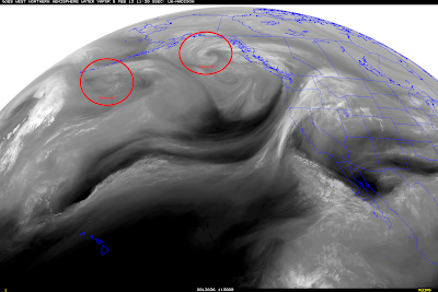
Two storms will merge over the Gulf of Alaska this week to form one strong storm that will drop southeastward and into the Great Basin by Friday. Our local weather is going to get busy this weekend into the first of next week.
But before then our long stretch of unusually quiet weather will continue with warm temps and mostly sunny skies. Our afternoon highs will range from the upper 60's to the mid 70's for the rest of this week here in southeastern New Mexico. In fact Carlsbad will be flirting with 80F by Saturday. Then winter returns to the state beginning this weekend and continuing into early next week.
GFS Forecast At 5 PM MST Fri February 8, 2013.
ECMWF Forecast At 5 PM MST Fri February 8, 2013.
Both the US GFS model and the European (ECMWF) model agree that a strong upper-level storm will drop southeastward out of the Gulf of Alaska and into the Great Basin by Friday. After this they disagree about the storms track and strength.
GFS Forecast At 5 PM MST Sat February 9, 2013.
ECMWF Forecast At 5 PM MST Sat February 9, 2013.
GFS Forecast At 5 PM MST Sun February 10, 2013.
ECMWF Forecast At 5 PM MST Sun February 10, 2013.
Last nights run of the GFS model lingers the strong upper-level storm over the Great Basin through the weekend. It then splits a piece of the storm off and carries it northeastward out into the plains states early next week, while leaving a piece of the storm behind over the Great Basin. The European model begins to split the storm by Sunday taking a piece of its energy northeast into Nebraska, and then later drops a piece of the storm southward into northwestern Mexico by Tuesday.
Either way colder and stormier weather will return to the area this weekend into the first part of next week. Strong southwesterly winds may kick up over southeastern New Mexico and parts of west Texas by late this week and into the weekend. Its even possible that the dryline may fire up across parts of west Texas and produce some strong thunderstorms.
Mountain snows will be possible with this storm, and some of the states lowlands could also see some of the white stuff depending upon the track of the storm. This is going to be a large and complicated winter storm so I'm pretty sure that the details are going to be a bear to figure out with this one. So no doubt there will be some changes in our local forecasts later this week.
Obviously if this storm drops further south than the GFS is forecasting then our chances for more widespread rain and snow will increase across the state. If it takes a more northern route and splits then southeastern New Mexico will have a better chance of getting more wind than rain or snow out of it.
The Truth Is Stranger Than Fiction!
My Web Page Is Best Viewed With Google Chrome.


Comments
Post a Comment
Your comments, questions, and feedback on this post/web page are welcome.