My Current Weather

Friday, May 30, 2014

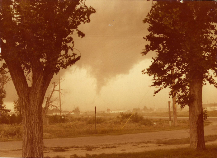
Indian Basin Gas Plant Hail Storm - Friday, May 23, 2014.


This video was shot by Richard Rivera at the Indian Basin Gas Plant (Oxy, Inc) located 12 miles WSW of Seven Rivers, New Mexico (on Marathon Rd) last Friday, May 23, 2014. His partner Dave Rouse who is a former co-worker and friend of mine reported that at one point the hail got up to golf ball and soft ball size The soft ball size hail shattered upon impact according to Dave. Dave said that it hailed for 30 minutes (7:05 PM MDT - 7:35 PM MDT).

The Truth Is Stranger Than Fiction! 

 My Web Page Is Best Viewed With Google Chrome.

Wednesday, May 28, 2014

SE NM Supercell T-Storms & Storm Chaser Videos. May 23 - 25, 2014.


My wife (Diane) and I chased this supercell thunderstorm 25 miles west-southwest of Seven Rivers, New Mexico on Friday, May 23, 2014. Many other storm chasers from across the nation, and even a few from overseas showed up to chase in our next of the woods Friday, Saturday, Sunday. Posted below are some of their videos.


The Truth Is Stranger Than Fiction! 

 My Web Page Is Best Viewed With Google Chrome.

Sunday, May 25, 2014

Supercell Time Lapse Video - 25 WSW Seven Rivers, NM. 5-23-2014.


My wife and I chased this supercell thunderstorm on Friday afternoon May 23, 2014. We first encountered it 25 miles west-southwest of Seven Rivers, New Mexico.

It produced a couple of wall clouds with some slow rotation. As this supercell moved east it bombed the Indian Basin Gas Plant (Oxy, Inc) with golf ball to softball size hail for 30 minutes (7:05 PM MDT - 7:35 PM MDT).

It also produced golf ball size hail on U.S. Hwy 285 just south of Seven Rivers, New Mexico. 

While I had my head in the clouds my wife was watching a couple of baby foxes poke their heads out of their den.

The Truth Is Stranger Than Fiction!

 My Web Page Is Best Viewed With Google Chrome.

Round Two Of Severe T-Storms Saturday, May 24, 2014.


Alan Edmonson who lives in Roswell, NM 
took this photo at  8:30 PM last night...from Roswell looking north.


A high water rescue occurred here yesterday morning when a motorist
attempted to cross the flooded arroyo. Turn Around - Don't Drown.


Flash flooding along sheep draw and Hackberry draw yesterday morning.


Hail on U.S. Hwy 62/180 at Whites City last night. I did get one report
 of at least one vehicle with its windows beat out by the hail.

Yesterday's overcast skies cleared up by noontime but the atmosphere over southeastern New Mexico took awhile to recover from Friday's thunderstorm activity. Just before sunset the atmosphere became sufficiently detestable again to give us round two of severe thunderstorms.


8:35 PM MDT Baseball size hail 1 mile south of Seven Rivers.
8:40 PM MDT Quarter size hail Whites City.
9:01 PM MDT Golf ball size hail Carlsbad Airport.
9:09 PM MDT Penny size hail 7 miles south of Carlsbad.
9:48 PM MDT Quarter size hail 9 miles northeast of Carlsbad on U.S. hwy 62.180.


Estimated Radar Storm Total Rainfall.
(Past Two Days).


It appears that the Midland NWS Dual Pol Doppler Radar has been overestimating our rainfall totals across southeastern New Mexico the past couple of days. This is due mainly to the hail contaminating the radar echoes. The Cannon AFB Radar Totals are not available this morning.

Two-Day Storm Total Rainfall Amounts-

Alan Edmonson Roswell 5.30"
8-Mile Draw Raws Northeast Of Roswell 4.93"
Roswell Airport ASOS 4.71"
Tatum Climate Co-Op Station 3.64"
Crossroads 2.43"
Milensand Davis Vantage Pro 2 .40"
Bat Draw Raws 1.96"
2.9 N Downtown Carlsbad 1.94"
2.1 NNW Downtown Carlsbad 1.64"
2.2 N Downtown Carlsbad 1.55"
Caprock Raws 1.52"
2.6 NNW Downtown Carlsbad 1.41"
Lovington Davis Vantage Pro 2 1.28"
Hobbs - Wood Farms Davis Vantage Pro 2 .84"
Mayhill CWOP CW9878 .78"
Artesia Airport ASC .71"
Alfadale - Atoka Davis Vantage Pro 2 .64"
Dunken Raws .63"
Carlsbad Airport ASOS .62"
Weed K5TCS .61"
Cloudcroft CWOP EW0726 .60"
Smokey Bear Raws - Ruidoso .41"
Pinery Raws - Pine Springs .41"
Padca Raws .20"
Queen Raws .07"

Rainfall Totals Are Courtesy Of-


The Truth Is Stranger Than Fiction! 

 My Web Page Is Best Viewed With Google Chrome.

Friday, May 23, 2014

Our First Chase Of The Season - Wall Clouds, Hail Cores, Baby Foxes, And Century Plants.


To Top The Day Off We Get This At Midnight.


Golf ball to Lime size hail fell at our home and across Carlsbad, NM 
for minutes or so at midnight last night. One report of Tennis Ball size
hail in northwest Carlsbad. 1.24" of rain at our home.

My wife (Diane) and I went storm chasing today. Although there were a couple of Tornado Warnings issued for just south of Carlsbad, New Mexico...we failed to see one. We did see several wall clouds, which at times showed some rotation.

While I had my head stuck in the clouds Diane spotted two baby foxes poking their heads up out of their den. Click on the pictures to enlarge them. She also shot the beautiful picture of the New Mexico Century Plants at the Rest Stop along U.S. Hwy 62/180, just south of the NM/TX State line.

Several reports of Golf Ball size hail were noted along U.S. hwy 285 between Dayton Road, south of Artesia, south to near the Brantley Lake State Park Headquarters around 7:00 PM MDT this evening. Please click on this link courtesy of the Midland National Weather Service Office to view additional severe weather reports from across the local area today. Also this one courtesy of the Albuquerque National Weather Service Office.

Earlier this evening I talked with one of my former co-workers and friend (Dave Rouse). He is working the night shift at the Indian Basin Gas Plant (Oxy, Inc) located 12 miles west-southwest of Seven Rivers, New Mexico, on Marathon Road (Eddy County Rd 401). Hail started falling at the plant at 7:05 PM MDT. It ended at 7:35 PM MDT. The hail ranged in size from golf balls to soft balls. The golf ball size hail piled up 2" inches deep on the ground and drifted. The soft ball size hail was fairly soft and shattered upon impact.

What a fun day...I had a blast chasing today's storms with my best friend...my wife! :)

The Truth Is Stranger Than Fiction! 

 My Web Page Is Best Viewed With Google Chrome.

First Round Of Severe Weather Yesterday - More On The Way Today.


Severe Thunderstorms Return To SE NM.


A Severe Thunderstorm wind gust knocked this tree down onto a
car in Roswell, NM yesterday afternoon. Photos are courtesy of


A sad and sobering occurrence of blowing dust and a resultant multi-fatality accident happened yesterday afternoon on I-10 between Lordsburg and the Arizona state line. Weak shower activity was in progress and it produced very strong outflow winds which raised dust off the Lordsburg playa. That dust significantly reduced visibility along that stretch of highway. In an instant six people lost their lives in a multi-vehicle accident which involved several cars and a semi-truck. The lesson here for the rest of us is to avoid that situation by getting off the highway when you see dust approaching. Please drive with a watchful eye for dust today. If you see dust ahead do not drive into it...assume it will become too thick to see beyond your hood. Give the dust 10 to 20 minutes to settle or move off the highway and then continue your travel. Not doing so could cost you your life.

Heavy Rains Fell Yesterday.


Estimated 24-Hour Rainfall Totals.
 Courtesy Of The Midland NWS Dual Pol Doppler Radar.


Estimated 24-Hour Rainfall Totals.
 Courtesy Of The Cannon AFB Dual Pol Doppler Radar.


Cottonwood Northwest Of Artesia measures .83".


Scattered thunderstorms are expected again today and tonight over all of West Texas and Southeast New Mexico. Any storms that do develop will be accompanied by frequent lightning, small hail, gusty winds, and heavy rainfall. A few storms north of a Van Horn, to Fort Stockton, to Sheffield line could become severe this afternoon and evening, with quarter size hail and damaging winds to around 60 mph. Heavy rainfall will also be possible, resulting in localized flash flooding. A Flash Flood Watch is in effect north of the Pecos, including all Eddy County, through Sunday afternoon


The Truth Is Stranger Than Fiction! 

 My Web Page Is Best Viewed With Google Chrome.

Wednesday, May 21, 2014

Just Like That - The Rains & Severe Weather Return.


Just like that, in typical southeastern New Mexico fashion, we go from bust to boom, from drought to heavy rains and severe weather...almost in a day's time. Thunderstorms are returning starting today and will continue into Saturday.

We are rolling into the heart of our severe weather season which is mid May through mid June. The good news is some badly needed rains will fall...the bad news is that these may be accompanied by bouts of severe thunderstorms today into Saturday.

Today's severe weather threats for the southeastern plains of New Mexico include large hail and possibly some damaging thunderstorm wind gusts in excess of 58 mph. Today's thunderstorms should be fairly isolated and I think that most of us will not see much if any rain due to this factor.

Better chances for thunderstorms, some of which may be severe, and more widespread rainfall, will exists tomorrow into Saturday. Large hail, damaging thunderstorm wind gusts, locally heavy rainfall, along with the possibility of localized flash flooding will be possible with any severe thunderstorm that occurs across the local area. 

Supercell thunderstorms may get rather robust and strong, especially on Friday, and I wouldn't be surprised to see a few tornadoes spin up. Especially as the atmosphere destabilizes as the upper level storm to our west gets closer. 

Here is a list of links to help keep you, your family, friends, and co-workers safe over the next couple of days:

National Weather Service Mobile Phone App Link for your phones-

Midland National Weather Service Web Page-http://www.srh.noaa.gov/maf/

Midland National Weather Service FaceBook Page-

Midland National Weather Service Office Twitter Account-

Albuquerque National Weather Service Office Web Page-

Albuquerque National Weather Service FaceBook Page-

Albuquerque National Weather Service Office Twitter Account-

El Paso National Weather Service Office Web Page-

El Paso National Weather Service Office FaceBook Page-

El Paso National Weather Service Office Twitter Account-

National Weather Service Storm Prediction Center Web Page-

My Web Page-

Stay safe everyone and here's hoping you get soaked!!! 
The Truth Is Stranger Than Fiction! 

 My Web Page Is Best Viewed With Google Chrome.

Tuesday, May 20, 2014

Staying Safe During Severe Weather.


Funnel Cloud Over Atoka, NM. June 13, 1984.

Roswell, NM Tornado April 8, 2004. 

Rotating Wall Cloud 3 Miles North Of Lakewood, NM.
October 11, 1997.

Our home in Carlsbad, New Mexico. My wife holding a bucket of hail.
March 7, 2010.

Whites City, NM Supercell Thunderstorm April 29, 2009.


Good morning all. We are still on track for some important changes in our local weather here in southeastern New Mexico and west Texas this week. The good news is that we still have a decent chance of seeing some wetting rains starting Wednesday and continuing into the weekend.

However its May and this is usually our most likely time of the year to experience severe thunderstorms. Mid May through Mid June is typically the heart of our severe weather season here in southeastern New Mexico.

With this thought in mind here are a couple of links to help keep you and your family safe in the event severe weather threatens your area.

1. This link is courtesy of the National Weather Service and is free. You should be able to use this on your phones as long as you have internet service. Simply type in your location of interest for all of the very latest up to date National Weather Service forecasts, Watches, Warnings, Special Weather Statements, Radar data, and other pertinent local weather data.

Example:

Roswell, NM or Roswell, New Mexico
Artesia, NM or Artesia, New Mexico
Carlsbad, NM or Carlsbad, New Mexico

http://mobile.weather.gov/#typeLocation

2. I also use Radar Scope on my Android phone for my radar updates. This service is not free and requires a small one time fee (at least on my Verizon Android). Local National Weather Service Watches, Warnings, and Storm Reports are available via this service too.

http://radarscope.tv/products/


The Truth Is Stranger Than Fiction!

 My Web Page Is Best Viewed With Google Chrome.

Sunday, May 18, 2014

100-Degrees Temps The Next Three Days - Then Come The Rains?


Valid BY 6 PM MDT Sunday, May 25, 2014.


Southeastern New Mexico will flirt with 100-degree temps today, tomorrow, and Tuesday. With these hot temperatures comes dry downsloping southwesterly winds and a very high fire danger for the area.

Then changes will begin by Wednesday as the models continue to hint at a cut off upper level low parking itself over the Desert Southwest by the middle to end of this week. This means a change in the wind flow at the low and mid levels of the atmosphere which will lead to an increase in moisture across the area.

Which of course means slightly cooler temps and an increased chance for some widespread rainfall. Its dryline season so we may also see some severe thunderstorms possibly as early as Wednesday and then on into the weekend as the storm to our west stalls.

Last nights 6 PM MDT run of the U.S. GFS model (first graphic above) gets rather excited about some heavy rainfall for us. I don't know yet if I buy the 5+ inches across the Guadalupe's by Sunday evening though. However the models continue the trend of producing some beneficial widespread rainfall across the area.

So we may also have to watch out for the possibility of some localized flash flooding with some of the stronger thunderstorms especially by the end of the week going into next weekend.

Last nights ECMWF model (second graphic above) was a little less generous with the heaviest rainfall totals by Sunday evening but like the GFS depicts a large area of heavy rainfall.

There are still lots of unknowns/maybes/ifs at this point but this is the most excited that the models have consistently been in forecasting widespread beneficial rains for the local area since last September.

Here's hoping/wishing/praying the models are right!!!! 

The Truth Is Stranger Than Fiction! 

 My Web Page Is Best Viewed With Google Chrome.

Thursday, May 15, 2014

Will Next Week Be Wet For NM?


ECMWF 10-Day Total Precipitation Forecast.
Valid Today Through Sunday May 25, 2014.

GFS 10-Day Total Precipitation Forecast.
Valid Today Through Sunday May 25, 2014.


Ok don't hold your breath or get your hopes up too high but take a look at the European (ECMWF) and the GFS model forecasts. This is their 10-day total precipitation forecasts valid today through Sunday May 25th.

Both models continue to forecast an upper level storm over Arizona and New Mexico by the middle to the end of next week...along with the prospect of some rain. Its always risking business when looking at model forecasts a week to ten days out. But for the first time in a long time both of these models are indicating a change...and a wet one at that.

It appears that our best chances for rain would be late next week. Lets hope!

The Truth Is Stranger Than Fiction! 

 My Web Page Is Best Viewed With Google Chrome.

NWS Albuquerque Burn Scar Matrix Forecast

Current NWS Watches/Warnings In Effect

New Mexico

Eddy County

Chaves County Plains & Mtn's

Culberson County

Lea County

Lincoln County

Otero County

Current US Temps

Current US Wind Chill/Heat Index Temperatures

NWS Midland Forecast

NWS Albuquerque Forecast

NWS Albuquerque Forecast

NWS El Paso Forecast

NWS Lubbock Forecast

NWS Lubbock Forecast

Average Daily High/Low Temperatures & Rainfall

Average Daily High/Low Temperatures & Rainfall