My Current Weather

Sunday, July 31, 2016

Monsoon Flow Has NM In Its Gunsights - Invest 97L To Continue West.
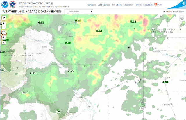

(As Of 6 AM MDT July 31, 2016).

July was not a wet month for most of southeastern New Mexico. In fact here at our home in Carlsbad I've only managed to pick up .27" for the month and 2.82" for the year so far.


The Clines Corners ASOS measured 1.97" of rain over the past 24 hours.


Past 24 Hours.
(As Of 8 AM MDT This Morning).


Past 48 Hours.
(As Of 8 AM MDT This Morning).


Past 72 Hours.
(As Of 8 AM MDT This Morning).


NDFD (NWS) Total Rainfall Forecasts.
(Valid At 6 PM MDT Tuesday, August 2, 2016).


(Valid At 6 AM MDT Sunday, August 7, 2016).


(Valid At 6 PM MDT Tuesday, August 2, 2016).


Roswell.


Carlsbad.


Ruidoso.


Cloudcroft.


An interesting trend in some of the forecast models this morning in that a few of them are trying to shift the Monsoonal moisture currently streaming into Arizona and much of New Mexico slightly eastward. Just enough to give us a chance this upcoming week for a few scattered thunderstorms...some of which could produce locally heavy rainfall. Will be fun to see if this pans out. Meanwhile our temperatures will remain close to, or slightly above seasonal normals.

Invest 97L.

Not a lot of change in the overall thinking and model forecasts concerning the track and strength of Invest 97L this morning. As far as its track goes a jog generally to the west is anticipated. Some of the models have it reaching tropical storm strength just east of the Yucatan Peninsula by Thursday morning. Some of them curve it northward and into the Gulf by the end of the week. Some of them keep it heading westward into the Yucatan Peninsula, and out into the Bay of Campeche and into Eastern Mexico by the end of the week or next weekend. Nothing is set in stone at this point so keep an eye on it.


Valid At 6:45 AM MDT This Morning.


ZCZC MIATWOAT ALL
TTAA00 KNHC DDHHMM

TROPICAL WEATHER OUTLOOK
NWS NATIONAL HURRICANE CENTER MIAMI FL
800 AM EDT SUN JUL 31 2016

For the North Atlantic...Caribbean Sea and the Gulf of Mexico:

1. Showers and thunderstorms associated with a strong and fast-moving
tropical wave now entering the extreme eastern Caribbean Sea are
disorganized, while satellite data and surface observations indicate
no signs of a closed surface circulation. Although some gradual
development of this system is possible during the next couple of
days, the chance for tropical cyclone formation should increase
after the wave reaches the western Caribbean Sea in a couple of
days. This disturbance is expected to bring locally heavy rains and
gusty winds to portions of the Lesser Antilles, the Virgin Islands,
and Puerto Rico today. These conditions should spread westward
across the eastern and central Caribbean Sea tonight and reach
Hispaniola on Monday. Interests in these areas and elsewhere in the
Caribbean Sea should continue to monitor the progress of this
system. For additional information on this system, see High Seas
Forecasts issued by the National Weather Service.
* Formation chance through 48 hours...medium...40 percent
* Formation chance through 5 days...high...70 percent

2. Disorganized shower and thunderstorm activity associated with a
tropical wave located nearly 700 miles west-southwest of the Cabo
Verde Islands has changed little in organization. This system should
continue moving westward at 10 to 15 mph, and development is
unlikely due to unfavorable upper-level winds.
* Formation chance through 48 hours...low...near 0 percent
* Formation chance through 5 days...low...near 0 percent

High Seas Forecasts issued by the National Weather Service can be
found under AWIPS header NFDHSFAT1, WMO header FZNT01 KWBC, and on
the Web at http://www.opc.ncep.noaa.gov/shtml/NFDHSFAT1.shtml.

Forecaster Kimberlain

The Truth Is Stranger Than Fiction!

Saturday, July 30, 2016

AZ/NM To Get Monsoon Rains & Invest 97L.


"Storm coverage is expected to increase further early next week
across all of western and a good portion of central NM. Models
still holding to somewhat varying degrees to the eastward shift
of the upper high and thus allowing greater amts of moisture to
flow in from the s and se. The easterly wave coming slowly west
and nwwrd across Mexico should help to some degree with this as
well. With the increasing moisture lvls still being advertised
decided to add locally heavy rain wording to the scattered/chance
to numerous/likely pops areas starting today and for the aftns
through Monday. Today may seem a bit too soon for that, but given
the uptick of yesterday felt that we could get away with that as
early as today. As previous day shifter indicated flash flood
watches may be needed for portions of next week depending on
antecedent heavy rainfall locations and presence of any
discernible dynamic and/or thermodynamic markers. Still looks like
the west half will be more favored than farther east for the more
widespread heavier rains, at least for the better part of the
upcoming week. Finally, the real deal monsoon looks like it is
kicking in!"

Total Rainfall Forecasts.
Valid @ 6 AM MDT Saturday, August 6, 2016.

Total Rainfall Forecasts.
Valid @ 6 AM MDT Saturday, August 6, 2016.

Total Rainfall Forecasts.
Valid @ 6 AM MDT Saturday, August 6, 2016.


Valid @ 6 AM MDT Saturday, August 6, 2016.

Valid @ 6 AM MDT Saturday, August 6, 2016.


Valid @ Midnight Saturday, August 6, 2016.

Valid @ Midnight Saturday, August 6, 2016.


Roswell's 7-Day Forecast.


Carlsbad's 7-Day Forecast.


Ruidoso's  7-Day Forecast.


Cloudcroft's 7-Day Forecast.


Although our annual monsoon appears to be kicking in over most of Arizona and New Mexico southeastern New Mexico will for the most part be left high and dry over this upcoming week. Most of the thunderstorm activity associated with the monsoon will occur from the Guadalupe, Sacramento, and Capitan mountains and westward. That's not to say that a few isolated storms won't pop up over the plains at times but overall we are expected to miss the main show.

It would appear that the Sacramento mountains could end up with some decent storm totals by a week from now...they need it so bring it on.

All eyes are on a couple of potential tropical storms possibly affecting the Gulf of Mexico and nearby areas next week. Invest 97L appears at this time to be the stronger of the two (96L, 97L). Its early yet so don't get too caught up in the forecast track of this system. Still room and time for lots of error and forecast corrections but worth keeping an eye on.


Issued @ 6 AM MDT Saturday, July 30, 2016.


Valid @ Noon MDT Thursday, August 4, 2016.


ZCZC MIATWOAT ALL
TTAA00 KNHC DDHHMM
TROPICAL WEATHER OUTLOOK
NWS NATIONAL HURRICANE CENTER MIAMI FL
800 AM EDT SAT JUL 30 2016
For the North Atlantic...Caribbean Sea and the Gulf of Mexico:
1. A tropical wave located about 700 miles east of the Lesser Antilles
activity has increased since yesterday, any additional development
is moving westward at 25 to 30 mph. While the associated shower should be slow to occur due to the rapid motion of the system.
Puerto Rico, and the eastern Caribbean Sea beginning later today.
Regardless of development, this system will likely bring showers and gusty winds to portions of the Leeward Islands, Virgin Islands,
* Formation chance through 48 hours...low...20 percent
By the middle of next week, the disturbance is expected to be in the western Caribbean Sea, where conditions could become more conducive for development.
southwest of Cabo Verde has become less organized during the past
* Formation chance through 5 days...medium...40 percent 2. Shower and thunderstorm activity associated with a tropical wave and a low pressure system centered a couple of hundred miles
* Formation chance through 48 hours...low...30 percent
24 hours. However, there is still a chance for some development during the next day or two before the disturbance encounters a less favorable environment over the central tropical Atlantic. * Formation chance through 5 days...medium...40 percent
Forecaster Beven

The Truth Is Stranger Than Fiction!

Tuesday, July 26, 2016

Heavy Rains Fell Over Parts Of New Mexico Yesterday & Overnight.


(As Of 8 AM MDT This Morning).


(Using GRLevel3 Software).


(As Of 8 AM MDT This Morning).


(Last Updated At 7:13 AM MDT This Morning).

• 6 WSW Bonito Lake - 2.52 in.
 • 4 W Bonito Lake - 2.48 in.
 • 5 SW Bonito Lake - 1.89 in.
 • 2 S Bonito Lake - 1.27 in.
 • 5 WNW Bonito Lake - 1.25 in.
 • 2 SW Dora - 0.91 in.
 • 6 WSW Bonito Lake - 0.91 in.
 • 1 SE Gran Quivira - 0.86 in.
 • 13 SE Tolar - 0.84 in.
 • 16 SSE Natl Radio Astronomy Obs - 0.70 in.
 • 3 NE Albuquerque - 0.68 in.
 • 1 SSE Clines Corners - 0.68 in.
 • 2 N Santa Fe - 0.66 in.
 • 7 ENE Tucumcari - 0.66 in.
 • 4 W Placitas - 0.61 in.
 • 3 NW Bandelier Natl Monument - 0.59 in.
 • 8 S Tijeras - 0.55 in.
 • 13 SE Tolar - 0.41 in.
 • 4 SSE Roswell - 0.41 in.
 • 11 WSW Bluewater Lake - 0.40 in.
 • 6 SSE Luna - 0.40 in.
 • 11 NNW Canon Plaza - 0.40 in.
 • 5 WNW Los Alamos - 0.40 in.
 • 13 NW Bandelier Natl Monument - 0.39 in.
 • 6 NE Ponderosa - 0.37 in.
 • 16 NNE Jemez Springs - 0.31 in.
 • 2 SSE La Cueva - 0.29 in.
 • 9 SSW Bluewater Lake - 0.29 in.
 • 1 NNE Bosque Del Apache Refuge - 0.27 in.
 • 3 ENE Truchas - 0.26 in.
 • 1 WNW White Rock - 0.24 in.
 • 17 NW Bandelier Natl Monument - 0.24 in.
 • 2 NNW Angel Fire - 0.23 in.
 • 9 NE Albuquerque - 0.22 in.
 • 6 NW Corona - 0.21 in.
 • 2 W El Morro - 0.21 in.
 • 8 SSW San Miguel - 0.20 in.
 • 6 ESE Mogollon - 0.20 in.
 • 2 NNW Ponderosa - 0.10 in.

The Truth Is Stranger Than Fiction!

Sunday, July 24, 2016

Just How Far Away Are Those T-Storms Anyway?


We Can See For Miles & Miles In NM.


Just How Far Away Were Those Thunderstorms Anyway? 

My wife and I were headed north up US Hwy 285 to Roswell yesterday afternoon when I shot the above two photos. We were looking northwest-north at the Eddy and Chaves County line just north of Artesia at 3:56 PM MDT. 

This morning I pulled up a snapshot archive of the Cannon AFB Dual Pol Doppler Radar from yesterday afternoon at 3:55 PM MDT. The thunderstorms stretching from our northwest-north were anywhere from 115-180 miles from us. We were first able to see the tops of these storms right after we left Carlsbad...placing them some 210+ miles north of us. 

Finally Its Going To Cool Down Some - With T-Storms.

Valid @ 6 PM MDT Wednesday, July 27, 2016.

Forecast models are showing that the oppressive upper level ridge of high pressure that has been plaguing the local area will shift to the northwest Tuesday into Thursday. This will allow an easterly wave at the mid levels of the atmosphere to work its way westward from South Texas towards us. This will allow low and mid level moisture and instability to increase over the area beginning Tuesday...along with cooler temperatures and thunderstorms. Our high temperatures in southeastern New Mexico and parts of West Texas may even be slightly below normal Wednesday and Thursday.

Hot Again Today & Monday - But A Cool Down Is Coming.


Valid @ 6 PM MDT Thursday, July 28, 2016.


T-Storms & Some Much Needed Rainfall Return This Week.

Valid @ 6 AM MDT Sunday, July 31, 2016.

Valid @ 6 PM MDT Sunday, July 31, 2016.

Valid @ 6 PM MDT Tuesday, July 26, 2016.

Valid @ 6 PM MDT Tuesday, July 26, 2016.

As is almost always the case the varying models are forecasting varying rainfall totals for the state this upcoming week...nothing unusual about that. So for the first time in a long time southeastern New Mexico and nearby areas will cool down by the middle of this week, and get wet. Given that the airmass will contain subtropical moisture some locals may even end up with some heavy rainfall. The mountains will be the favored areas and some storm totals by next weekend could exceed 2-3"

The Truth Is Stranger Than Fiction!

NWS Albuquerque Burn Scar Matrix Forecast

Current NWS Watches/Warnings In Effect

New Mexico

Eddy County

Chaves County Plains & Mtn's

Culberson County

Lea County

Lincoln County

Otero County

Current US Temps

Current US Wind Chill/Heat Index Temperatures

NWS Midland Forecast

NWS Albuquerque Forecast

NWS Albuquerque Forecast

NWS El Paso Forecast

NWS Lubbock Forecast

NWS Lubbock Forecast

Average Daily High/Low Temperatures & Rainfall

Average Daily High/Low Temperatures & Rainfall