Hurricane Ida Tropical Cyclone Update NWS National Hurricane Center Miami FL AL092021 1155 AM CDT Sun Aug 29 2021 ...EXTREMELY DANGEROUS CATEGORY 4 HURRICANE IDA MAKES LANDFALL NEAR PORT FOURCHON LOUISIANA... NOAA Doppler radar imagery indicates that the eye of Ida made landfall along the southeastern coast of Louisiana near Port Fourchon around 1155 AM CDT (1655 UTC). Data from an Air Force Reserve reconnaissance aircraft and Doppler radar data indicate that Ida's maximum sustained winds at landfall were estimated to be 150 mph (240 km/h). The latest minimum central pressure estimated from reconnaissance aircraft data is 930 mb (27.46 in). Within the past hour, sustained winds of 43 mph (69 km/h) and a gust to 67 mph (107 km/h) were reported at Lakefront Airport in New Orleans. A NOAA National Ocean Service tide gauge in Shell Beach, Louisiana, recently reported a water level of 6.4 feet above mean higher high water, which is an approximation of inundation in that area. A NOAA National Ocean Service tide gauge at Bay Waveland Yacht Club, Mississippi, recently reported a water level of 5.5 feet above mean higher high water, which is an approximation of inundation in that area. SUMMARY OF 1155 AM CDT...1655 UTC...INFORMATION ----------------------------------------------- LOCATION...29.1N 90.2W ABOUT 15 MI...25 KM SW OF GRAND ISLE LOUISIANA ABOUT 45 MI...75 KM SE OF HOUMA LOUISIANA MAXIMUM SUSTAINED WINDS...150 MPH...240 KM/H PRESENT MOVEMENT...NW OR 320 DEGREES AT 13 MPH...20 KM/H MINIMUM CENTRAL PRESSURE...930 MB...27.46 INCHES $$ Forecaster Brown/BrennanOVER THE GULF OF MEXICO - Flying into the eye of Category 4 Hurricane #Ida on NOAA WP-3D Orion #NOAA43 Miss Piggy during morning mission 08.29.21. Credit: Lt. Cmdr. Doremus, NOAA Corps. Visit https://t.co/JRMe4KQZfE for NOAA event resources. #FlyNOAA pic.twitter.com/STHD6mWwgd
— NOAA Aircraft Operations Center (@NOAA_HurrHunter) August 29, 2021Hey @Shell is this true? #HurricaneIda #IDA #lawx @NHC_Atlantic pic.twitter.com/d4Zl9CqkkE
— Larry Bell (@LBell911) August 29, 2021
SE Plains & Guadalupe Mtn's Forecasts
Sacramento Mtn's Forecasts
My Current Weather
My Daily Climate Summary
Sunday, August 29, 2021
Cat 4 Ida Makes Landfall Near Port Fourchon, Louisiana.
Cat 4 Hurricane Ida 40 Miles South Of Grand Isle, Louisiana.
Hurricane Ida Tropical Cyclone Update NWS National Hurricane Center Miami FL AL092021 900 AM CDT Sun Aug 29 2021 ...900 AM CDT POSITION UPDATE... ...NORTHERN EYEWALL OF IDA APPROACHING THE COAST OF SOUTHEASTERN LOUISIANA... An elevated NOAA C-MAN station at Southwest Pass, Louisiana, recently reported a sustained wind of 102 mph (165 km/h) and a wind gust of 116 mph (187 km/h). Another elevated NOAA C-MAN station at Pilot's Station East near Southwest Pass recently reported a sustained wind of 97 mph (156 km/h) and a gust to 121 mph (194 km/h). A NOAA National Ocean Service observing site at Pilottown, Louisiana, recently reported a sustained wind of 52 mph (84 km/h) and a gust of 77 mph (124 km/h). SUMMARY OF 900 AM CDT...1400 UTC...INFORMATION ---------------------------------------------- LOCATION...28.7N 89.8W ABOUT 40 MI...65 KM SSE OF GRAND ISLE LOUISIANA ABOUT 90 MI...145 KM SSE OF NEW ORLEANS LOUISIANA MAXIMUM SUSTAINED WINDS...150 MPH...240 KM/H PRESENT MOVEMENT...NW OR 320 DEGREES AT 14 MPH...22 KM/H MINIMUM CENTRAL PRESSURE...930 MB...27.46 INCHES $$ Forecaster Brennan/BrownThe 👁️ of this beast and its roiling, supercharged eyewall. Praying for the safety of everyone in the path of #Ida.🙏 pic.twitter.com/BFIUDW2jEE
— Stu Ostro (@StuOstro) August 29, 2021EYE OF A MONSTER: @NOAA's #GOESEast 🛰️ gives an up-close look at the lightning swirling around the eye of #HurricaneIda, a dangerous Cat. 4 #hurricane, nearing the coast of southeastern #Louisiana.
— NOAA Satellites (@NOAASatellites) August 29, 2021
Please stay safe!
More: https://t.co/arzjJiHnjF#LAwx #MSwx #idahurricane #ida pic.twitter.com/QosgjNT87l
The Truth Is Stranger Than Fiction!This mornings visible satellite imagery of #ida is both frightening and beautiful. Stay with @WESH for updates. pic.twitter.com/ySngHe2iwG
— Tony Mainolfi (@TMainolfiWESH) August 29, 2021
Friday, August 27, 2021
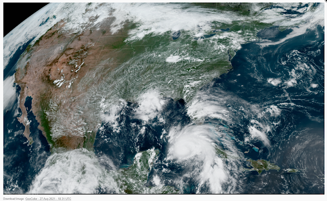
Hurricane Ida Headed For Louisiana?
BULLETIN
Hurricane Ida Intermediate Advisory Number 5A
NWS National Hurricane Center Miami FL       AL092021
200 PM EDT Fri Aug 27 2021

...IDA MAKES LANDFALL AS A HURRICANE ON THE ISLE OF YOUTH...


SUMMARY OF 200 PM EDT...1800 UTC...INFORMATION
----------------------------------------------
LOCATION...21.6N 82.7W
ABOUT 5 MI...10 KM E OF THE CENTER OF THE ISLE OF YOUTH
ABOUT 145 MI...245 KM E OF THE WESTERN TIP OF CUBA
MAXIMUM SUSTAINED WINDS...75 MPH...120 KM/H
PRESENT MOVEMENT...NW OR 325 DEGREES AT 15 MPH...24 KM/H
MINIMUM CENTRAL PRESSURE...987 MB...29.15 INCHES.
Local Products for Ida
U.S. Watch/Warning Local Products |
Local Statements are prepared by National Weather Service Weather Forecast Offices (WFO) giving specific details for their County Warning Area (CWA) on weather conditions, evacuation decisions made by local officials, and other precautions necessary to protect life and property.
On this page are links to the Local Statements that have been released within the last 8 hours, as well as links to the homepages of the issuing Weather Forecast Offices.
Wednesday, August 25, 2021
Hurricane Threat In The Gulf Of Mexico Early Next Week?
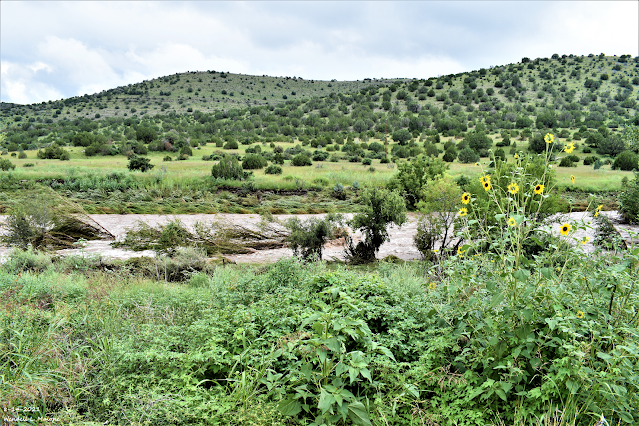
This area is normally dry and is not the main channel of the river. The river runs up against the hill in the background and is usually only a foot or so deep, and less than 10 feet wide. The Penasco had overflowed its banks and flooded the pasture area in the photo. At one point earlier in the morning it had overflowed up on US Hwy 82 for a brief time.
Thursday, August 19, 2021
Regional Year-To-Date Rainfall Totals.
New Mexico
Eddy County
Chaves County Plains & Mtn's
Culberson County
Lea County
Lincoln County
Otero County
Average Daily High/Low Temperatures & Rainfall


