Slow Moving Thunderstorms = Heavy Rainfall & Flash Flooding!
Flash Flooding After The Rio Penasco Jumps It's Banks.
Runoff From The Canyon On The North Side Of The Hwy Also.
Slow Moving Thunderstorms Will Produce Heavy Rainfall & Flash Flooding!
European (ECMWF) Model.
Valid Today Through 11 PM MDT Monday, August 2, 2021.
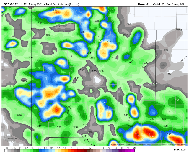
US (GFS) Model.
Valid Today Through 11 PM MDT Monday, August 2, 2021.
NAM 3KM Model.
Valid Today Through 11 PM MDT Monday, August 2, 2021.
NWS NDFD Model.
Valid Today Through 6 AM MDT Wednesday, August 4, 2021.
WPC 10-Day Forecast Model.
Rainfall has been widespread over the region so far this summer. Totals for July are coming in at least the normal range to above normal in all areas. Green grass and foliage are everywhere which is a much-welcomed site to see.
Our monsoon has been a blessing so far this summer and likely will continue to be so. July, August, and September are the wettest months of the year locally.
A slow-moving cold front crawling southward down the eastern plains will sag into Southeastern New Mexico and West Texas tonight and Monday, then become stationary over the area. Abundant low-level and mid-level moisture combined with lift from the front and the mountains, and an unstable atmosphere will produce widespread thunderstorms this afternoon into Monday night.
Local rainfall totals today into Tuesday should end up averaging 1" to 2". Scattered pockets of 2" to 4" will occur, especially over and near the mountains. A few isolated areas of 4" to 6" will be possible.
Rainfall totals this afternoon into Monday could easily approach 2" per hour with the stronger thunderstorms. Possibly higher in a few storms.
Localized flash flooding will be a concern this Sunday afternoon into Tuesday morning. Maybe beyond in some areas. A Flash Flood Watch is in effect into late tonight for Lincoln and Chaves Counties. Be on the alert for the possibility of additional Flash Flood Watches and Flash Flood Warnings this afternoon into Monday across the local area.
Localized flash flooding will be a concern this Sunday afternoon into Tuesday morning. Maybe beyond in some areas. A Flash Flood Watch is in effect into late tonight for Lincoln and Chaves Counties. Be on the alert for the possibility of additional Flash Flood Watches and Flash Flood Warnings this afternoon into Monday across the local area.
The Truth Is Stranger Than Fiction!


Comments
Post a Comment
Your comments, questions, and feedback on this post/web page are welcome.