

Storm Summary - 72 Hour Rainfall Totals Saturday, June 4, 2022.

2:51 PM MDT, June 3, 2022.
LP Supercell T-Strom West Of Hope, NM.
June 3, 2022.
My Storm Chase Video.
LP Supercell Time-Lapse Hope, NM.
Blog Updated At:
11:12 AM MDT Sunday, 6-5-2022
I went storm chasing Friday afternoon and ended up 8 miles southwest of Hope when I shot this photo. This low precipitation supercell thunderstorm produced very little rainfall which is often typical of LP storms and scattered large hail. Storm chasers reported quarter to hen egg size hail in southwest Chaves County west of Hope and east of Dunken. Cyclic low-level rotation was observed from time to time with this storm.
(As Of 6 AM MDT Saturday, June 4, 2022).


(As Of 8 AM MDT Saturday, June 4, 2022).


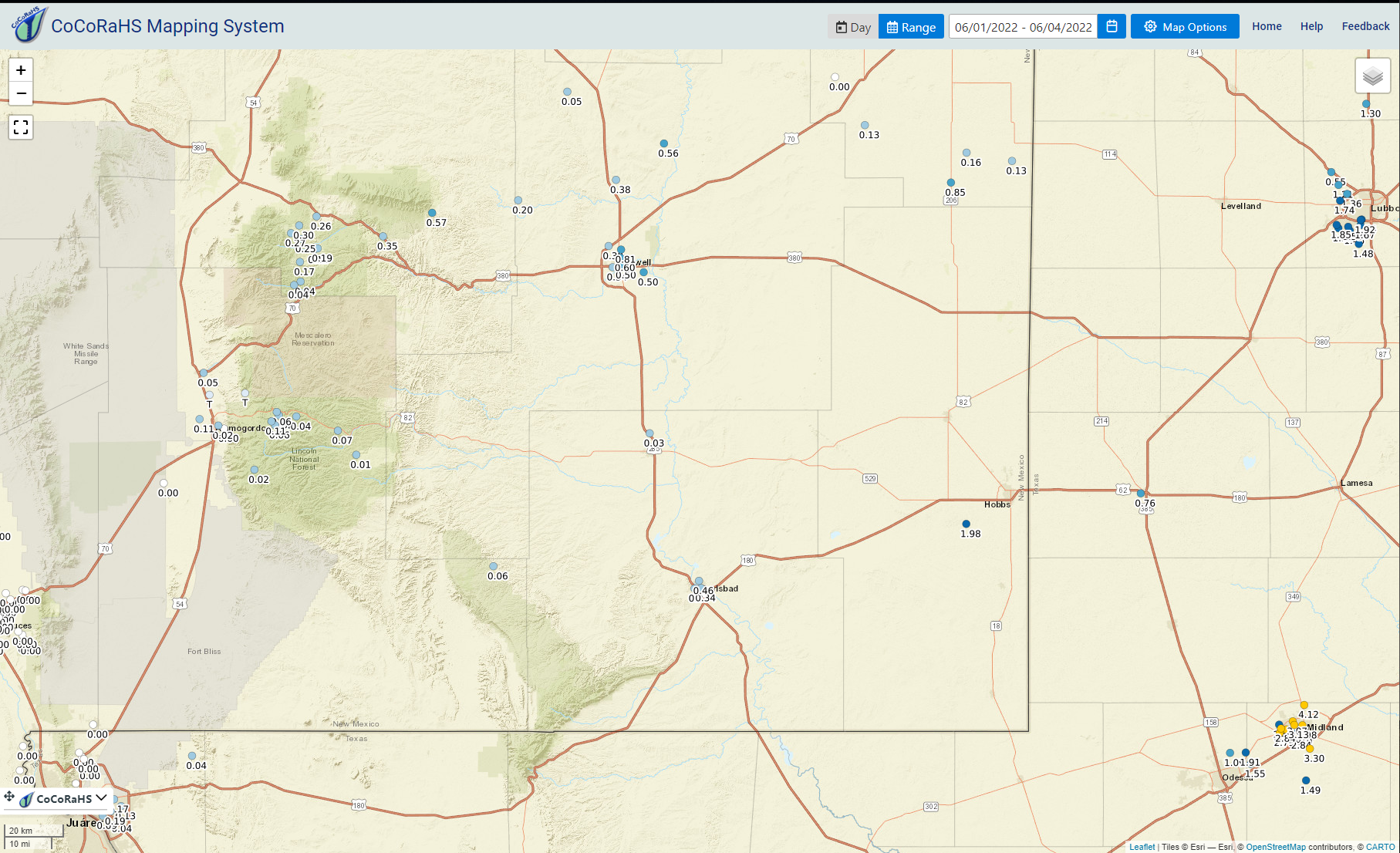


Our latest round of thunderstorms has come and gone. Some of us got a lot of rain while most did not. Another case of the have's and have nots. The highest 72-hour measured rainfall total that I can find is the 1.98" reported at the Monument CoCoRaHS Station southwest of Hobbs. Overall Lea County saw the highest rainfall totals estimated by radar with 6.51" noted west of Eunice.
My three-day total at our home in Carlsbad is .27" bringing my year-to-date rainfall total to .52". At 6:38 PM MDT Friday hen eggs size hail (2.0" in diameter) was reported 8 miles northeast of Whites City southwest of Carlsbad. Golf ball size hail was reported 2 miles east-northeast of Halfway on the Hobbs Hwy at 5:49 PM MDT.
Public Information Statement
National Weather Service Albuquerque NM
933 AM MDT Sat Jun 4 2022

...PRECIPITATION REPORTS...

Location                     Amount    Time/Date

...New Mexico...

...Chaves County...
Roswell Air Center           0.29 in   0851 AM 06/04
Roswell No. 1 Portable       0.21 in   0640 AM 06/04
Roswell 3.4 NNE              0.19 in   0700 AM 06/04
Roswell 5.1 N                0.18 in   0800 AM 06/04
Roswell 6.0 NNW              0.16 in   0700 AM 06/04
Roswell 1.7 NW               0.10 in   0649 AM 06/04
Roswell 28.5 NNE             0.10 in   0700 AM 06/04

...De Baca County...
Fort Sumner 10.9 SSE         0.21 in   0600 AM 06/04
Fort Sumner 9.0 SSE          0.17 in   0630 AM 06/04

...Harding County...
Solano 3 NW                  0.25 in   0800 AM 06/04
Mills 4 WSW (Mills Canyon)   0.20 in   0605 AM 06/04

...Lincoln County...
Arabela 2.5 SSW              0.34 in   0700 AM 06/04
Roswell No. 2 Portable       0.33 in   0620 AM 06/04
Lincoln 1.4 ESE              0.19 in   0500 AM 06/04

...Roosevelt County...
Milnesand                    0.35 in   0700 AM 06/04

...San Miguel County...
Mosquero 15 SSE              0.16 in   0700 AM 06/04

...Union County...
Capulin Volcano Natl Monument 0.10 in   0820 AM 06/04

Observations are collected from a variety of sources with varying
equipment and exposures. We thank all volunteer weather observers
for their dedication. Not all data listed are considered official.

$$
There Are None So Blind As Those Who "Will - Not" To See...107.


Comments
Post a Comment
Your comments, questions, and feedback on this post/web page are welcome.