Widespread Rainfall Some Heavy Today - Wednesday. Flash Flooding Possible.
(7-Day Total Rainfall Forecast)
(Today - 6 PM MDT Sunday, June 26, 2022).
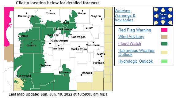
Flood Watches have been issued for much of the state including parts of northern New Mexico, western New Mexico, and the northern Sacramento mountains today and this evening.
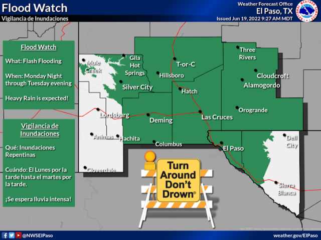
Also included in the Flood Watches are southern and southwestern New Mexico and the southern Sacramento mountains from this afternoon through Tuesday.
Also included in the Flood Watches are southern and southwestern New Mexico and the southern Sacramento mountains from this afternoon through Tuesday.
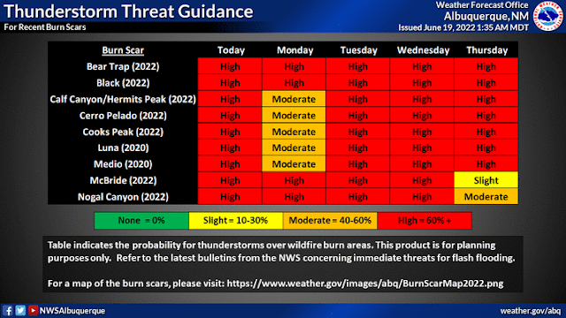
Life-threatening flash flooding is increasingly becoming more likely in the above-mentioned areas this afternoon through Wednesday. Of particular concern and the recent burn scars from this spring's forest fires in New Mexico...as well as older ones from previous years.
Flash flood warnings are possible during this time frame so stay weather aware and be prepared to move to higher ground or a place of safety if a flash flood warning is issued for your location.
Additional flash flood watches are possible for other areas of the state not currently mentioned tonight through Wednesday. Keep abreast of changing weather conditions and forecasts and be prepared to act accordingly.
Forecast models continue to shift the southwest to the northeast oriented band of expected heavy rainfall eastward with time. So this means that the eastern and Southeastern Plains may also get in on the action from this afternoon into Wednesday at times.
The latest NAM model forecast this Sunday morning gets pretty excited about a bulls-eye total rainfall amount of up to 4.0" - 8.0" along the east slopes of the northern Sacramento mountains by Wednesday evening. Remember the forecast models are just guides so use them with caution. Heavier rainfall may occur in areas that are not currently forecast to get rain or heavy rain than what the models are forecasting. And some places may not get as much as the models above indicate.
Bottom line is that much of the state is going to get moderate to heavy rainfall between today and the middle of next week. Some locations may see excessive storm totals greater than 2.0" - 4.0".
There Are None So Blind As Those Who "Will - Not" To See...107.


Comments
Post a Comment
Your comments, questions, and feedback on this post/web page are welcome.