


Dangerous Life-Threatening - Possibly Catastrophic Flash Flooding Possible Today Into Thursday!

Looking Northwest.
Between Brownfield & Lubbock, Tx.
Heavy To Very Heavy Rains This Past Weekend.
A severe thunderstorm hammered southern Carlsbad and the Otis area this past Saturday afternoon. At 4:53 PM MDT, the Carlsbad Airport ASOS recorded a severe thunderstorm wind gust of 76 mph during a wet microburst. Numerous reports of downed trees, tree limbs, power poles, power lines, and sheds blown down were shared on Social Media pages. I don't have photos of these because I am still locked out of Facebook. I've made several appeals to have my account reinstated, but Facebook isn't responding to my requests.
Record rainfall also fell at the airport, with 2.13" of rain also recorded during this event, which caused bar ditch, field, and street flooding in the area. This set a new daily 24-hour record high rainfall total at the airport that exceeded the previous record of .63" there in 1999. The Carlsbad NWS Climate Co-Op Station recorded 1.00" in 1977.
A severe thunderstorm produced a wind gust of 84 mph at the Davis Vantage Pro PWS (66 Ranch) located 7 miles northwest of Roswell, on Billy Jack Road, Sunday afternoon. That station also recorded 1.78" of rainfall.
At 6:17 PM MDT, the Roswell Airport ASOS recorded a severe thunderstorm wind gust of 74 mph on Sunday afternoon. Other severe thunderstorm wind gusts include 67 mph 6 miles NNW of Rosell in Apache Hills, 66 mph on Cotton Road 7 miles NW of Roswell. Power lines and utility poles and lines were blown down 3 miles north of Roswell and 3 miles ENE of Roswell. 1" or quarter-size hail was measured 6 miles NW of Roswell. At least one high-water rescue occurred 7 miles northwest of Roswell due to flash flooding.
A Weather Underground PWS located northwest of Roswell on Poppy Road recorded a 24-hour rainfall total of 5.65" as of midnight last night. Other nearby PWS's recorded 2" to over 3" of rain. The Roswell Airport ASOS recorded .79" of rainfall as of midnight last night.
Dangerous Life-Threatening - Possibly Catastrophic Flash Flooding Today Into Thursday!
A Flood Watch remains in effect today through Wednesday evening for parts of the eastern and southeastern plains and Lincoln County in the Sacramento Mountains.
A Flood Watch remains in effect today through Wednesday evening for parts of southern New Mexico, including Otero County.
A Flood Watch remains in effect today into this evening for Eddy and Culberson Counties and parts of West Texas.
Dangerous flash flooding has already occurred in the Ruidoso, Roswell, and Carlsbad areas over the weekend. Abundant subtropical moisture will continue to increase and stream northward and northeastward into the state from northern Mexico today into Thursday.
Roswell experienced catastrophic flash flooding last October 19th when the airport officially recorded 5.78" of rain in 24 hours, although most of that fell in just a couple of hours. This broke their all-time 24-hour rainfall record of 5.65" set on November 1st, 1901. In town, widespread rainfall totals of 6" to 11" were noted, with one report of 12" in northeast Roswell.
Scattered to numerous rain showers and thunderstorms will dot the landscape of much of the state today into Friday. Thunderstorms will become more widespread, producing heavy to very heavy rain in the central mountains, southern deserts, eastern, and southeastern plains on Tuesday.
Flash flooding may occur just about anywhere in the state today into Friday, but the highest risks appear to be today into Wednesday.
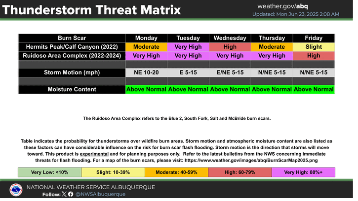
Of particular concern are the burn scar areas of the state, especially in the Ruidoso and nearby locations, and the Hermit Peak areas. Life-threatening to catastrophic flash flooding may occur in these and other nearby local areas today through Thursday. The Roswell and Carlsbad areas will also have to be watched carefully since they too received very heavy to excessive rainfall Saturday and Sunday.
Forecast models are spitting out storm total rainfall amounts today through Friday, generally in the 1" to 4" range across the lower elevations. And 3" to 7" across parts of the Sacramento and central mountain chains. It's not out of the question that a few spots could potentially see more than this when the total rainfall amounts are added up today through Friday.
New Mexico and especially the southeastern plains, the Capitan, Sacramento, and Guadalupe Mountains have a long history of deadly flash floods, with many deaths recorded over the past 130 years. Don't be fooled by how dry it was last year and this spring. In fact, over the past four years.
Tens of thousands of newcomers now live in the area, and most of them have no idea how bad our flash flood events can be. Just because we haven't seen much rain recently does not mean that we will continue to do so. We are entering our typical summer monsoon pattern, and heavy rainfall and flash flooding will rule our headlines this week.
Scattered marginally severe thunderstorms are forecast today, and thunderstorms will be efficient heavy rain producers today into Friday. Some of the stronger storms will be capable of producing rainfall rates of 2" to 4" or more in an hour, and this will potentially produce life-threatening flash flooding.
Do not drive through flooded low-lying areas, ditches, normally dry arroyos, intersections, and low-lying flooded city streets.
Turn Around - Don't Drown!
7:43 PM - June 22, 2025 - 3,033 Views.
Video Courtesy Of Robert Holcomb.
6:39 PM -June 22, 2025 - 7,874 Views.
Video Courtesy Of Donald Wenner.
Cannon AFB Dual Pol Doppler Radar Rainfall Estimates.


MRMS 72-Hour Rainfall Sunday.


(As Of 11:30 PM MDT Sunday, June 22, 2025).


(TodayThrough 6 AM MDT Thursday).


There Are None So Blind As Those Who "Will - Not" To See...107.


Comments
Post a Comment
Your comments, questions, and feedback on this post/web page are welcome.