My Current Weather

Monday, April 30, 2012

Another Round Of Severe Thunderstorms Across West Texas This Afternoon - Tonight.
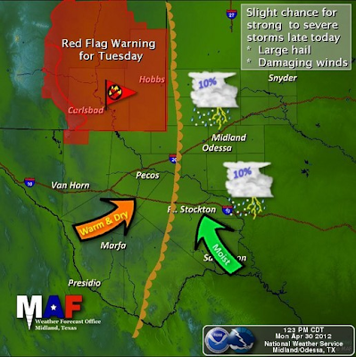


Hail up to 2.5" In Diameter & 70 MPH Wind Gusts Possible.

Severe thunderstorms are already erupting southwest of the Fort Stockton Area as of 1:55 PM MDT. Additional thunderstorms are forecast to develop across parts of southwest and west Texas this afternoon and evening. Southeastern New Mexico should remain free of the activity.

The Truth Is Stranger Than Fiction!

 My Web Page Is Best Viewed With Google Chrome.

Lubbock, Texas Gets Bombed With Baseball Size Hail Last Night.

Click On The Photos To Enlarge Them.

Blog updated at 10:17 AM MDT Tue May 1, 2012.


I grabbed this GRLevel2-AE Storm Relative Velocity (SRV)
screen shot last night at 6:42 PM MDT/7:42 PM CDT.

Very tight rotation within the HP Supercell T-Storm extending
right off the surface up to around 30,000' MSL.
A Tornado Vortex Signature (TVS) was also indicated.

A High Precipitation (HP) Supercell thunderstorms bombed the Lubbock, Texas area last night with golf ball to baseball size hail and high winds. The storm thankfully became a right mover as it neared the western areas of the city, and turned to the southeast and passed to the south of most of Lubbock.

The Wolfforth, Texas Mesonet automated weather station located about 7 miles southwest of downtown Lubbock, recorded a 95 mph wind gust along with baseball size hail. Numerous reports of golf ball to baseball size hail was reported in the Lubbock area yesterday evening, especially south and southwest of Lubbock.

Please visit this link to view some of the storm reports courtesy of the Lubbock National Weather Service Office. Other reports courtesy of the Storm Prediction Center (SPC) can be view via this link. Officials from the Lubbock National Weather Service Office are out conducting a damage survey today, and they will likely have the results of this survey posted on their web page in a day or two, so check it for additional information on the storm.

The Truth Is Stranger Than Fiction!

My Web Page Is Best Viewed With Google Chrome.

Sunday, April 29, 2012

A Few Severe T-Storms Near The State Line.

Blog Updated At 2:45 PM MDT.

Map Is Courtesy Of The Midland NWS Office.
It appears that the best chances for severe thunderstorms in New Mexico today will be near the NM/TX state line, from roughly around the Portales and Clovis area northward to the Colorado state line. Unless things change later this afternoon and evening, it now appears that our chances for seeing thunderstorms here in southeastern New Mexico have diminished.

Lea County might get a few thunderstorms late this afternoon and evening. Current forecasts give the best chances for thunderstorms this afternoon and evening along and east of the dryline, which will lie roughly along and east of a Tatum-Fort Stockton-Big Bend line. A few severe thunderstorms are possible across parts of west Texas today, especially in the upper Colorado Valley area.

We can expect to see the thermometer climb up into the upper 80's to the low 90's today. Monday's highs will be in the low-mid 90's, and this will be true for the rest of the work week.

Long-range model forecasts do not offer any realistic hope for significant rainfall across southeastern New Mexico over the next week to ten days.

The Truth Is Stranger Than Fiction!

My Web Page Is Best Viewed With Google Chrome.

Saturday, April 28, 2012

Severe T-Storms Make A Return Especially Sunday.

Blog Updated At 12:55 PM MDT.


Surface Map forecast Valid At 6 PM MDT Today.

This Map Was Issued At 11:53 PM MDT Friday Night.

This Updated Map Issued At 11:30 AM MDT Saturday.

A cold front will slowly slide southward today into this evening into southeastern New Mexico. It will retreat northward as a warm front later tonight into tomorrow morning. The dryline will remain parked across west Texas today, but will slosh westward back into southeastern New Mexico tonight.

A mid-level short wave is forecast to approach the area tomorrow evening, while the dryline is forecast to sharpen up across southeastern New Mexico tomorrow afternoon. Low level southeasterly upslope flow will return tonight behind the cold front and dryline. A fairly decent supply of Gulf of Mexico moisture will return to the area and will aide in the development of t-storms on Sunday.

Today will be mostly sunny and warm across the local area. Most of us will see afternoon high temperatures in the upper 80's to near 90. Sunday will be a little warmer with our afternoon highs climbing back up into the low 90's.

A few isolated thunderstorms may break out along the retreating frontal boundary this evening across far southeastern New Mexico and west Texas. A few isolated severe thunderstorms ( severe thunderstorms produce hail that is one inch in diameter, or the size of quarters or larger, and t-storm wind gusts of 58 mph or higher) will be possible, especially just to the east in west Texas across the northeastern Permian Basin this evening.

Surface based cape values are forecast to be around 3300 j/kg, along with steep mid level lapse rates, and impressive heliciity values this evening. Therefore, a few isolated supercell t-storms will be possible, especially in west Texas in the northeastern Permian Basin area.

There currently is a 20% chance for Skywarn Storm Spotter Activation across far southeastern New Mexico and parts of west Texas this evening. There will be a better chance for Skywarn Storm Spotter Activation across parts of southeastern New Mexico and west Texas on Sunday.

Sunday looks even more favorable for scattered thunderstorms across the area. A few of these thunderstorms may be of the supercell variety, especially across Lea County northward into eastern New Mexico, and eastward into west Texas. These thunderstorms will be capable of producing large hail, deadly cloud to ground lightning, and damaging t-storm wind gusts in excess of 58 mph, along with localized heavy rainfall.

Mixed layer cape values are forecast to be around 1500-2000 j/kg on Sunday, along with effective wind shear values of 40-50 knots. Surface dew point temperatures are forecast to be around 60-degrees along and south of the frontal boundary, and east of the dryline. The low-level jet will fire up across the area around sunset, and this will aide in the development of a few supercell thunderstorms.

Some of these thunderstorms will be capable of producing some locally heavy rainfall amounts, but overall the coverage of these storms is forecast to be rather scattered in nature, so most of us may not see significant rainfall.

I plan on chasing tomorrow across southeastern New Meixco and maybe west Texas.

The Truth Is Stranger Than Fiction!

My Web Page Is Best Viewed With Google Chrome.

Thursday, April 26, 2012

New All-Time April Record Highs Set On Wednesday.

Click On The Maps To Enlarge Them.

Blog updated at 6:10 AM MDT Fri April 27, 2012.


Daily Record Highs Set Wednesday.


Monthly Record Highs Set Wednesday.


Blistering heat for late April established new record high temperatures across the area yesterday afternoon. I really hope that yesterday's heat is not a precursor of what the rest of our spring and summer has to offer.

New All-Time April Record High Temperatures
Set On Wednesday.

Lubbock, Texas topped out at 104, which breaks the previous record high of 100 for the month of April set on April 16, 1925, and April 22, 1989.

Midland, Texas topped out at 104, which breaks the previous record high of 101 for the month of April set on April 21, 1989, and April 27, 1996.

The Roswell, New Mexico Airport topped out at 102, which breaks the previous record high of 101 for the month of April set on April 22, 1965.

The Carlsbad, New Mexico Airport topped out at 101, which ties the previous record high of 101 for the month of April last set on April 21, 1965.

The Carlsbad Climate Co-Op Station topped out at 101, which beats the previous record high of 100 for the month of April set on April 18, 1909, April 16, 1925, April 22, 1934, and April 24, 1943.

The Carlsbad Caverns Climate Co-Op Station topped out at 96, which beats the previous record high of 95 for the month of April last set on April 22, 1989, April 23, 1989, and April 30, 2002.

The Hobbs, New Mexico Climate Co-Op Station topped out at 101, which beats the previous record high of 98 for the month of April set on April 18, 1987, and April 21, 1989.

The Tatum Climate Co-Op Station topped out at 97, which ties the previous record high of 97 for the month of April last set on April 22, 1965, April 23, 1989, and April 28, 1996.

The Jal Climate Co-Op Station topped out at 102, which ties the previous record high of 102 for the month of April last set on April 21, 1965.

Note- The Artesia Climate Co-Op Station topped out at 100, which beats the previous record high temp for the date (April 25th) of 98 last set on April 28, 1996, and April 23, 1965.
However, the all-time April high of 104 set on April 10, 1934 still stands unchallenged.


Maps Are Courtesy Of The Albuquerque NWS Office.


Maps Are Courtesy Of The El Paso NWS Office.

High Wind Warnings are in effect for today for parts of southern New Mexico where southwesterly winds are forecast to gust up to around 55 mph. Wind Advisories are in effect for the southern Sacramento Mountains for today, including the Cloudcroft and Mayhill areas. Southwesterly winds are forecast to gust up to 55 mph. A Blowing Dust Advisory is also in effect for parts of southern New Mexico today and this evening.

High Wind Warnings are also in effect for much of the rest of New Mexico today into this evening, including the Ruidoso area in Lincoln County. Southwesterly winds are forecast to gust up to around 55-60 mph. A High Wind Watch continues in effect for this evening for the Guadalupe Mountains. Southwesterly winds are forecast to gust up to around 60 mph.

Red Flag Warnings cover the area today for Critically Dangerous Fire Weather Conditions. Please avoid any type of outdoor activity that involves the use of sparks or flame today. Any fire that may be accidentally started will have the ability to rapidly spread and grow in the strong wind gusts and extremely dry conditions.

The Pretty Bird Fire located 16 miles northeast of Pinon in the southern Sacramento Mountains continues to burn out of control as of yesterday's briefing. It had consumed 126 acres and was 0% contained. It is burning in very rough terrain.

Another hot day is in store for us today. Our afternoon high temperatures should climb up into the mid-upper 90's, and with these readings a few daily record high temperatures may be jeopardy of falling. A thick deck of mid-high level clouds will damper our highs just a tad and should keep today's readings down a few degrees below yesterday's. Southwesterly winds will kick up later today at around 15-25 mph with some locations seeing gusts of around 35-40 mph.

A cold front is still forecast to enter the area Friday night, which will spread cooler weather across the area into the weekend. Most of southeastern New Mexico will see highs in the 80's.

A trough of low pressure in the mid-upper levels of the atmosphere to our west this weekend, will eject disturbances northeastward across the state into the first of next week. These disturbances combined with an increase in low-level moisture should produce a few scattered t-storms across SE NM Saturday into the first of next week. Right now it appears that these t-storms will be the mostly hit and miss types, and many of us may not get much rainfall out of them.

The Truth Is Stranger Than Fiction!

My Web Page Is Best Viewed With Google Chrome.

Wednesday, April 25, 2012

Record Heat Today - Heat & Wind Thursday.

Blog updated at 5:55 PM MDT.


A few high based, mostly dry t-storms, formed along the east slopes of the Sacramento and Guadalupe Mountains yesterday afternoon. One of these storms managed to drift southeastward into Carlsbad around 3:30 PM. I only recorded a trace of rain at my home as did the Carlsbad Airport ASOS. As of 7 AM MDT, the only measurable rainfall I have been able to find was the .01" at the Bowl Raws, which is located just north of Guadalupe Peak. These dry t-storms typically produce very little rainfall, lots of virga (as seen in the photos above), occasional cloud to ground lightning strikes, gusty dry microburst winds that can exceed 50 mph, and patchy areas of localized blowing dust.

Today & Thursday.


Update at 9:00 AM MDT- A dry t-storm producing cloud to ground lightning strikes yesterday started three fires in the Pinon and Dunken areas. This fire has been named the Pretty Bird Fire. The fire has burned 50-60 acres.

Unusually hot weather (for late April) is anticipated today and Thursday. Our afternoon high temperatures are forecast to be around 100 today across the southeastern plains. I suspect that a few spots may top the century mark. Many of our daily record high temperatures may fall today and tomorrow. There is also the possibility that a few locations may see their all-time April high temperature records tied or broken today. Click on this link for my post yesterday listing our local record temperatures across the local area.

Thursday is looking like one of those spring days that we all hate to see come around. With afternoon high temperatures forecast to rise up into the mid-upper 90's, and southwesterly winds picking up to around 25-30G45 mph, there will likely be areas of blowing dust develop. Once again its blast furnace weather time.

A High Wind Watch remains in effect for Thursday for the Guadalupe Mountains. Southwesterly winds are forecast to increase to 35-45 mph with gusts to around 65 mph. A High Wind Watch remains in effect for Lincoln County for Thursday also. Southwesterly winds are forecast to increase to 30-45G55-60 mph.

Please be be especially cautious when traveling around our local highways and come upon those normally dust prone areas such as freshly plowed and exposed farmlands and fields, lots, and construction sites. The visibility may drop down to near zero in some of these spots during the higher wind gusts, which may produce localized blinding clouds of blowing dust with little to no advanced warning. Here is the link to the video of the blinding dust storm that I shot in the Artesia area on February 28th of this year. Its a pretty good example of what I am talking about.

Not only will we have to deal with the hot dry winds and blowing dust tomorrow, the fire danger will be extreme as well. A Fire Weather Watch remains in effect for the area for tomorrow. Please refrain from any type of outdoor activity that involves the use of sparks or flame. Any wild fire that may accidentally start will have the potential to rapidly spread and grow in the gusty winds.

T-Storms Late This Weekend?


A cold front is forecast to enter the area late this weekend which should produce cooler weather and the chance for scattered thunderstorms. We may see a few severe thunderstorms return to the area Sunday and Monday. There are lots of unknowns at this point but it is something to look forward too.

The Truth Is Stranger Than Fiction!

My Web Page Is Best Viewed With Google Chrome.

NWS Albuquerque Burn Scar Matrix Forecast

Current NWS Watches/Warnings In Effect

New Mexico

Eddy County

Chaves County Plains & Mtn's

Culberson County

Lea County

Lincoln County

Otero County

Current US Temps

Current US Wind Chill/Heat Index Temperatures

NWS Midland Forecast

NWS Albuquerque Forecast

NWS Albuquerque Forecast

NWS El Paso Forecast

NWS Lubbock Forecast

NWS Lubbock Forecast

Average Daily High/Low Temperatures & Rainfall

Average Daily High/Low Temperatures & Rainfall