My Current Weather

Saturday, November 30, 2013

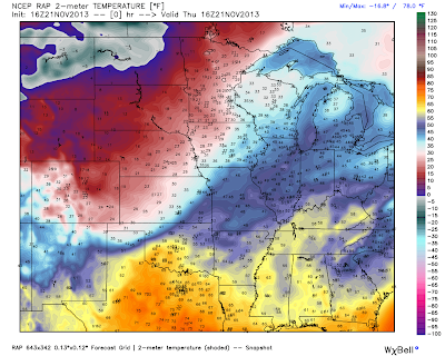
Another Blast Of Arctic Air Headed South.


Valid @ 5 PM MST Thursday, Dec 5, 2013

Valid @ 5 AM MST Thursday, Dec 5, 2013.

Valid @ 5 PM MST Thursday, Dec 5, 2013.

Valid @ 5 PM MST Thursday, Dec 5, 2013.

Get ready New Mexico...another blast of frigid air from the arctic is headed our way later next week. The models are all over the place concerning this next storm so the details are up for grabs for now. The European has been trending deeper and further south with the upper-level trough, which would indicate a better chance for more snow for the state if this trend continues and verifies.

A very cold arctic airmass is headed south once again. Temps across the central Rockies are forecast to bottom out Thursday morning somewhere in the neighbor hood of -35F. temps ahead of the front Thursday afternoon in the local area will be near 70F, behind the front temps will be below zero to our north.

Its possible that the arctic front may arrive as early as Wednesday. More on this later.

The Truth Is Stranger Than Fiction! 

 My Web Page Is Best Viewed With Google Chrome.

Thursday, November 28, 2013

Happy Thanksgiving!


That's Not Snow Its Frost On The Ground. Wednesday Morning
At The Beach In Carlsbad, New Mexico.

HAPPY THANKSGIVING EVERYONE!

The Truth Is Stranger Than Fiction! 

 My Web Page Is Best Viewed With Google Chrome.

Tuesday, November 26, 2013

Satellite Images Of The Snow Cover In New Mexico.


Runyan Ranches located just east of Mayhill near Elk experienced an ice storm just like the Pecos Valley. Some of their trees like most of our here in the valley had turned colors but hadn't dropped their leaves yet. The ice and snow storm changed this, 

Sierra Blanca Peak glistens with a fresh coating of snow (10") from the storm. Ski Apache is set to open Thanksgiving Day.

Today satellite images from NASA shows the snow pack over the northern sections of southeastern New Mexico, and across eastern New Mexico. You can also pick out the snow cover over the Guadalupe and Sacramento mountains. Most of our snow has melted here in the Pecos Valley. Storm totals of 2" - 4" were common. A few locations around Portales ended up to 7" - 8" hence its taking a little longer for the snow to melt. 

The Truth Is Stranger Than Fiction! 

 My Web Page Is Best Viewed With Google Chrome.

Monday, November 25, 2013

Look At What The Models Are Seeing For Next Week!


12Z/5 AM MST ECMWF 500 MB Height Anomaly Forecast.
Valid @ 5 AM MST Thursday, December 5, 2013

12Z/5 AM MST ECMWF Max Temperature Forecast.
Valid @ 5 AM MST Thursday, December 5, 2013.

12Z/5 AM MST ECMWF Max Temperature Forecast.
Valid @ 5 AM MST Thursday, December 5, 2013.

12Z/5 AM MST ECMWF Min Temperature Forecast.
Valid @ 5 AM MST Thursday, December 5, 2013.

12Z/5 AM MST ECMWF Min Temperature Forecast.
Valid @ 5 AM MST Thursday, December 5, 2013.

12Z/5 AM MST ECMWF Temperature Anomaly Forecast.
Valid @ 5 AM MST Thursday, December 5, 2013.


18Z/11 AM MST ECMWF 500 MB Height Anomaly Forecast.
Valid @ 11 AM MST Thursday, December 5, 2013

 18Z/11 AM MST GFS Max Temperature Forecast.
Valid @ 11 AM MST Thursday, December 5, 2013.

18Z/11 AM MST GFS Max Temperature Forecast.
Valid @ 11 AM MST Thursday, December 5, 2013.

 18Z/11 AM MST GFS Min Temperature Forecast.
Valid @ 11 AM MST Thursday, December 5, 2013.

 18Z/11 AM MST GFS Min Temperature Forecast.
Valid @ 11 AM MST Thursday, December 5, 2013.

 18Z/11 AM MST GFS Temperature Anomaly Forecast.
Valid @ 11 AM MST Thursday, December 5, 2013.

Look what the models are seeing for the middle of next week! Those kind of temperatures are just nuts for the end of November and the beginning of December. I would expect to see this in January or February but not this early in the season. Those temperatures if they verify will be some 40-50 degrees below normal across much of the northern Rockies. Lows of -30F in southeastern Wyoming...seriously? 

The Truth Is Stranger Than Fiction! 

 My Web Page Is Best Viewed With Google Chrome.

Sunday, November 24, 2013

Carlsbad's First Snow Of The 2013-2014 Season.


Blog updated at 4:00 PM MST.
Blog updated at 8:00 AM MST Monday, Nov 25, 2013.

Courtesy Of The Midland NWS Office.

Carlsbad, NM This Morning.

Our Granddaughters Snowman In Artesia, NM.

I have measured .84" of liquid precipitation in the past 24-hours, with a total of 3.2" of snowfall, 3" on the ground in Carlsbad as of 7 AM MST. My liquid storm total is .90", and my storm total snowfall is 3.3"

NWS Albuquerque Snowfall Reports-

7.5" Dora
7.5" 3 SW Portales
6.5" Ski Apache 
5.0" 1 SW Clovis
4.5" 16 E Elkins
4.5" Milnesand
4.5" Elida
4.0" Corona 
4.0" Hagerman
3.5" 3 NE Ruidoso 
2.5" 16 NE Dunken 
2.5" 1 W Roswerll
2.0" Ruidoso 
2.0" 6 NNW Dunken 
1.5" Roswell

NWS El Paso Snowfall Reports-

3.8" 2 NE Alamogordo 
1.1" 3 WNW Mayhill
1.0" Cloudcroft

CoCoRaHS Snowfall Reports-

3.2" My Home In Carlsbad
2.8" 4 NNE Roswell
2.0" 3.5 NNE Artesia

Local Public Reports-

4.0" Cottonwood, North Of Artesia
3.0" 9 WNW Carlsbad
2.0" - 3.0" Around Carlsbad

Please click on the links to view additional snowfall reports. I will update this list as additional local totals become available. It appears that the Sacramento mountains did not get anywhere near the amount of snow that was being forecast...which is somewhat surprising. 

The Truth Is Stranger Than Fiction! 

 My Web Page Is Best Viewed With Google Chrome.

Saturday, November 23, 2013

The Change Over Sleet & Snow Has Begun In SE NM.


Blog Updated @ 3:25 PM MST.

Roads Are Getting Slick & Icy In Carlsbad, NM.
Light drizzle has changed over to light sleet and light snow.


Here we go...we just changed over to snow here in Carlsbad. Take a look at the latest satellite image below. Notice the large area of yellow shaded colors that stretches from south of El Paso, all the way north to southeastern Colorado.

This indicates and area of enhanced lift...which means here comes the sleet and snow. This disturbance is not the main storm...its still west of us, and is centered over southern California. Its forecast to move into the state Sunday afternoon.

My SE NM Radar Snapshot @ 2:30 PM MST.

When you visit my web page to view this radar please be sure and check the "Winterize Box" at the top of the radar page. This changes the radar viewing mode over to the winter mode. Light snow is showing up near Artesia and Carlsbad in the snapshot above, with light rain southeast of Midlalnd, and sleet near Lubbock. 

Notice too that on the two sidebars on each side of the main page there are eight smaller radar images. Click on any of these on my main web page, and the center image changes to the one you select. On the left hand side are the Albuquerque, Cannon AFB, Holloman AFB, and El Paso radar images. On the right hand side are the Amarillo, Lubbock, Midland, and Artesia radar images. Artesia does not have a doppler radar, this is an image from the Midland NWS Dual Polarization Doppler Radar...I named it Artesia because it is centered on Artesia, and is the central view for southeastern New Mexico.


The Truth Is Stranger Than Fiction! 

 My Web Page Is Best Viewed With Google Chrome.

Rare & Beautiful SE NM Ice Storm.


We don't see ice storms in southeastern New Mexico very often. They can be very dangerous and deadly but at the same time are very beautiful. I took the first photo above yesterday morning at the beach in downtown Carlsbad. Steam fog was forming on the river. The other photos were shot this morning. So far 24 hours of light freezing drizzle, light freezing rain, light sleet, and little bit of light snow has produced only minor icing...hopefully this trend continues today. 

The Truth Is Stranger Than Fiction! 

 My Web Page Is Best Viewed With Google Chrome.

Friday, November 22, 2013

Get Ready - A Major Winter Storm Is Headed Our Way!


Valid @ 11 AM MST This Morning.

Valid @ 5 AM MST Tuesday.

18Z/11 AM MST GFS Accumulated Snowfall Forecast.
Valid @ 5 AM MST Tuesday.

12Z/5 AM MST GEM Accumulated Snowfall Forecast.
Valid @ 5 AM MST Tuesday.

12Z/5 AM MST ECMWF Total Snowfall Forecast.
Valid @ 5 AM MST Tuesday.

12Z/5 AM MST NAM Accumulated Snowfall Forecast.
Valid @ 5 PM MST Monday.

18Z/11 AM MST NAM/WRF Total Accumulated Snowfall Forecast.
Valid @ 11 PM MST Sunday.

Light freezing drizzle, light freezing rain, and freezing fog have been ongoing across the local area since early this morning. Some of our local roadways have icy spots on them with icing occurring on exposed surfaces. This will continue tonight into tomorrow. Our temperatures will continue to hover at or near the freezing mark although the wind chill will make it feel much colder.

As of noontime today our potent upper-level storm (cutoff from the jet stream flow to the north of it) was parked just off the southern California coast. The forecast models continue their recent trends of slowly dragging this storm eastward and into the state by Sunday. Just exactly what track it will take is going to determine where the heaviest snows will fall. The mountains continue to look like they are going to get clobbered with heavy snowfall totals. Some of the higher east facing slopes may end up getting between one and two feet out of this storm, if not more in a few isolated spots.

Winter Weather Advisories, Winter Storm Watches, and Winter Storm Warnings are in effect across the local area, all of New Mexico, and parts of west Texas. There will be somewhat of a lull in the storm tonight into tomorrow, expect for the freezing drizzle and freezing rain that is ongoing east of the mountains across the plains. 

Things will really begin to ramp up and go down hill Saturday afternoon into Sunday as the potent upper-level storm to our west begins to approach the state. Dangerous winter weather driving conditions that now exists will only get worse with time. Snow some of which will be heavy, blowing and possibly drifting snow will be an issue on most of the states roads as well as across parts of west Texas. Difficult and dangerous driving conditions are expected, and some areas it simply may become impossible to go anywhere. 

Here in southeastern New Mexico it now appears that we may end up with 4" - 8" of snow out of this storm. Some of us could even see more than this, especially over and near the mountains. Current thinking is that the storm will not clear the area now until Tuesday.

Please visit the following National Weather Service Offices
 for the very latest on this impending Major Winter Storm-

Amarillo

Lubbock

Midland

El Paso

Albuquerque

The Truth Is Stranger Than Fiction!

 My Web Page Is Best Viewed With Google Chrome.

Thursday, November 21, 2013

Temperatures To Plunge After Dark - Major Winter Storm Coming!


RAP Temperatures @ 9 AM MST This Morning.

RAP Temperatures @ 9 AM MST This Morning.

WRF/NAM Forecast Temperatures.
Valid @ 8 PM This Evening.

WRF/NAM Forecast Temperatures.
Valid @ 8 AM MST Friday.

WRF/NAM Forecast Temperatures.
Valid @ 5 PM MST Friday.


As of 10 AM MST this morning the long awaited strong arctic cold front had moved south of Clayton, New Mexico. At 10 AM Clayton was reporting light freezing rain and mist with a temperature of 28F and dropping. Their wind chill value was 14F and dropping also. 

Current model forecasts indicate that the arctic cold front will be entering southeastern New Mexico by around 8 PM MST this evening. It will then continue to plunge southward, moving south of the local area around midnight.

 A very cold airmass for this time of the year will settle in over the area tonight into at least Sunday. Wind chill values will fall into the teens tonight and tomorrow over the area. Highs on Friday and Saturday will struggle to get much above freezing, with some locations only seeing the mid-upper 20's.

GFS Precipitation Type Forecast.
Valid @ 5 AM MST Friday.

GFS Precipitation Type Forecast.
Valid @ 5 AM MST Saturday.

GFS Precipitation Type Forecast.
Valid @ 5 AM MST Sunday.

ECMWF Total Snowfall.
Valid @ 5 AM MST Monday.

GFS Total Snowfall Forecast.
Valid @ 5 AM MST Monday.

NAM 3-Hourly Accumulated Snowfall Forecast.
Valid @ 5 PM MST Sunday.

GEM Accumulated Snowfall Forecast.
Valid @ 5 AM MST Monday.

Without any question our impending potentially Major Winter Storm with its impacts upon New Mexico and nearby areas is well...complicated to say the least. The models continue to stick to their guns as far as developing an ice storm over the southeastern plains late tonight into Sunday.

Without a doubt you will notice the frontal passage tonight when it arrives. Carlsbad is forecast to reach 75F this afternoon, and will struggle to get much above freezing Friday and Saturday. We will see a drop in temperatures behind the arctic cold front of some 40 - 50 degrees! A true "Blue Northerner" is headed south so get the fire wood stacked up and the extra blankets out.

 What they don't agree on is just exactly where the heaviest snow will fall over the lower valley locations of the state. The mountains looked primed to get clobbered by some respectable heavy snowfall amounts between today and Monday. I still think some spots may be measuring their storm total snowfall amounts by the feet by the time this is all said and done. 

Of particular concern to me is the European (ECMWF) models ongoing trend towards developing heavier snowfall totals over the local area, while expanding this aerial coverage with each new run. Heavy snowfall on top of ice would spell horrible driving conditions! Not that they won't be bad enough as it is should this current forecasts of an ice storm verify.

 Road closures across the state and nearby areas could become widespread and continue into Monday. At the very least our highways will become skating rinks that will be extremely dangerous. Travel in some areas may be very difficult if not impossible. 

This continues to be an ongoing and evolving situation so please check my web page often for the very latest National Weather Service updates, watches, warnings, special weather statements, forecasts, and radar data concerning this dangerous inbound winter storm. 

Hang on folks...this winter storm may be one for the record books!


Please visit the following National Weather Service Offices
 for the very latest on this impending Major Winter Storm-

Amarillo

Lubbock

Midland

El Paso

Albuquerque

The Truth Is Stranger Than Fiction! 

 My Web Page Is Best Viewed With Google Chrome.

NWS Albuquerque Burn Scar Matrix Forecast

Current NWS Watches/Warnings In Effect

New Mexico

Eddy County

Chaves County Plains & Mtn's

Culberson County

Lea County

Lincoln County

Otero County

Current US Temps

Current US Wind Chill/Heat Index Temperatures

NWS Midland Forecast

NWS Albuquerque Forecast

NWS Albuquerque Forecast

NWS El Paso Forecast

NWS Lubbock Forecast

NWS Lubbock Forecast

Average Daily High/Low Temperatures & Rainfall

Average Daily High/Low Temperatures & Rainfall