Temperatures To Plunge After Dark - Major Winter Storm Coming!
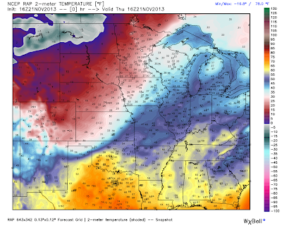
RAP Temperatures @ 9 AM MST This Morning.
RAP Temperatures @ 9 AM MST This Morning.
WRF/NAM Forecast Temperatures.
Valid @ 8 PM This Evening.
WRF/NAM Forecast Temperatures.
Valid @ 8 AM MST Friday.
WRF/NAM Forecast Temperatures.
Valid @ 5 PM MST Friday.
As of 10 AM MST this morning the long awaited strong arctic cold front had moved south of Clayton, New Mexico. At 10 AM Clayton was reporting light freezing rain and mist with a temperature of 28F and dropping. Their wind chill value was 14F and dropping also.
Current model forecasts indicate that the arctic cold front will be entering southeastern New Mexico by around 8 PM MST this evening. It will then continue to plunge southward, moving south of the local area around midnight.
A very cold airmass for this time of the year will settle in over the area tonight into at least Sunday. Wind chill values will fall into the teens tonight and tomorrow over the area. Highs on Friday and Saturday will struggle to get much above freezing, with some locations only seeing the mid-upper 20's.
GFS Precipitation Type Forecast.
Valid @ 5 AM MST Friday.
GFS Precipitation Type Forecast.
Valid @ 5 AM MST Saturday.
GFS Precipitation Type Forecast.
Valid @ 5 AM MST Sunday.
ECMWF Total Snowfall.
Valid @ 5 AM MST Monday.
GFS Total Snowfall Forecast.
Valid @ 5 AM MST Monday.
NAM 3-Hourly Accumulated Snowfall Forecast.
Valid @ 5 PM MST Sunday.
GEM Accumulated Snowfall Forecast.
Valid @ 5 AM MST Monday.
Without any question our impending potentially Major Winter Storm with its impacts upon New Mexico and nearby areas is well...complicated to say the least. The models continue to stick to their guns as far as developing an ice storm over the southeastern plains late tonight into Sunday.
Without a doubt you will notice the frontal passage tonight when it arrives. Carlsbad is forecast to reach 75F this afternoon, and will struggle to get much above freezing Friday and Saturday. We will see a drop in temperatures behind the arctic cold front of some 40 - 50 degrees! A true "Blue Northerner" is headed south so get the fire wood stacked up and the extra blankets out.
What they don't agree on is just exactly where the heaviest snow will fall over the lower valley locations of the state. The mountains looked primed to get clobbered by some respectable heavy snowfall amounts between today and Monday. I still think some spots may be measuring their storm total snowfall amounts by the feet by the time this is all said and done.
Of particular concern to me is the European (ECMWF) models ongoing trend towards developing heavier snowfall totals over the local area, while expanding this aerial coverage with each new run. Heavy snowfall on top of ice would spell horrible driving conditions! Not that they won't be bad enough as it is should this current forecasts of an ice storm verify.
Road closures across the state and nearby areas could become widespread and continue into Monday. At the very least our highways will become skating rinks that will be extremely dangerous. Travel in some areas may be very difficult if not impossible.
This continues to be an ongoing and evolving situation so please check my web page often for the very latest National Weather Service updates, watches, warnings, special weather statements, forecasts, and radar data concerning this dangerous inbound winter storm.
Hang on folks...this winter storm may be one for the record books!
Please visit the following National Weather Service Offices
for the very latest on this impending Major Winter Storm-
Amarillo
Lubbock
Midland
El Paso
Albuquerque
for the very latest on this impending Major Winter Storm-
Amarillo
Lubbock
Midland
El Paso
Albuquerque
The Truth Is Stranger Than Fiction!
My Web Page Is Best Viewed With Google Chrome.


Comments
Post a Comment
Your comments, questions, and feedback on this post/web page are welcome.