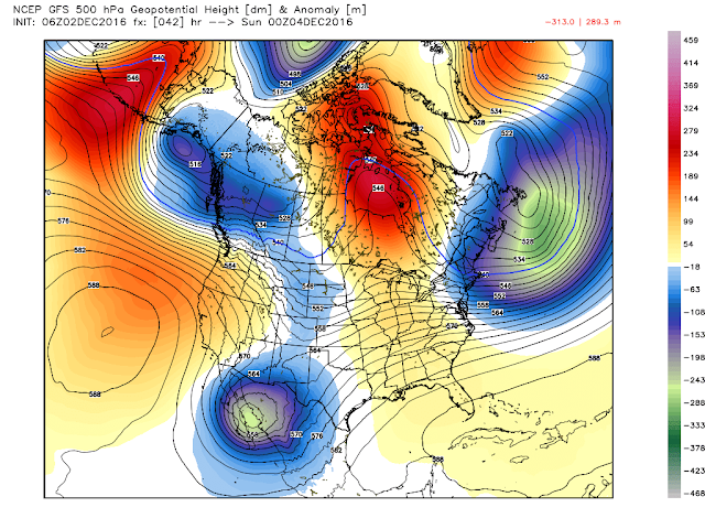
My Current Weather

Saturday, December 24, 2016

Snow For Some Areas Of NM This Christmas - And The Wind Will Howl Christmas Day!


National Weather Service Watches/Warnings In Effect.
(Click On The Link Above For The Latest Information).
Valid At 3:30 PM MST This Christmas Eve.

Merry Christmas everyone! A dynamic and strong cold winter storm is currently plowing through the Western U.S. as of this writing. Its effects upon New Mexico tonight into Christmas Day will be quick and hard hitting. Some of us in the Land of Enchantment will have a White Christmas while others may have a Brown Christmas.

Windy & Dusty In SE NM Christmas Day!

Friday, December 23, 2016

A White Christmas For New Mexico This Year!


Blog Updated At 2:59 PM MST Friday Afternoon. 


Halfway Between Artesia And Roswell, NM. 12-22-2016.

Not only has this year been a bumper crop for needle grass, the tumbleweeds are doing great too. Tumbling tumbleweeds all over the place across Southeastern New Mexico after this summer rains. They pile up against anything facing west such as this fence line south of Roswell. Miles and miles of these things can be found along our north-south facing fences. The Sons Of The Pioneers came out with a song about them in 1944...Tumbling Tumbleweeds

Heavy Rain Instead Of Heavy Snow Over The Sacramento Mtn's.

Wednesday, December 21, 2016

Wintry Mix Of Rain-Freezing Rain-Sleet-Snow Over NM Tonight Into Friday.


Valid At 3:30 PM MST This Afternoon. 

A very complicated winter weather event will unfold across New Mexico tonight into Thursday. Pockets of light rain are already developing over the southern one half of the state and this will increase and expand north and east into the night. A mixed bag of rain, freezing rain, sleet, and snow is forecast to break out over the Sacramento Mountains around midnight and spread north and northeast across the state into Thursday noontime. 

Tuesday, December 20, 2016

Two Winter Storms Headed Our Way - The Second Just In Time For Christmas.


Valid December 1st -19th, 2016. 

Blog Updated At 2:02 PM MST Wednesday, Dec 21st.


So far this December has been a couple of degrees below normal for most of Eastern and Southeastern New Mexico. Roswell set a new daily record low temperature of 6ºF this past Sunday, December 18th. The previous low temperature for that date was 7ºF set in 1964. 

The Carlsbad Climate Co-Op Station also set a new daily record low temperature on the morning of the 19th with a reading of 11ºF which beats the previous low of 12ºF set in 1996.

The Jal Climate Co-Op Station tied their record low of 6ºF on the morning of the 19th last set back in 1997. 

Two Winter Storms Headed Our Way - The Second In Time For Christmas!

Sunday, December 18, 2016

Saturday's Peak Wind Gusts & This Mornings Low Temperatures.


Photos Are Courtesy Of Arely Lara Of Carlsbad, NM.

A wind gust of 81 mph was clocked by the Guadalupe Pass ASOS at 9:51 AM MST Saturday morning. The automated weather station had some issues with its wind data throughout the day so I don't know if this was the highest gust recorded yesterday or not. Bad day to be trying to battle the wind in the Pass as evidenced by the photos above courtesy of Arely Lara of Carlsbad via her post on my Facebook Wall. 

Coldest Temperatures Of The Season To Date.

Saturday, December 17, 2016

Damaging Winds & Blowing Dust Today - Temperatures Plunge Tonight!


Blog Updated At 9:00 AM MST This Saturday Morning.

12-17-2016
Courtesy Of My Mother - Frances Callaway In Atoka (South Of Artesia, NM).

Last year, the day after Christmas a historic blizzard was razing Southeastern New Mexico and produced 12" to 20" snowfall totals along with drifts that were 3' to 10' high. This year a week before Christmas we are dealing with great piles of needle grass! This stuff is scary because its so flammable and goes up as fast as gasoline. Yesterday's peak wind gust of 53 mph at the Artesia Airport helped to redistribute this stuff all over the local area.

12-16-2016

Taken at sunrise Friday morning I was looking back to the north from my gas plant. This lenticular cloud was directly over Carlsbad when I left for work. Strong winds aloft ride up and over the ridge tops of the the mountains and create these beautiful formations. 

Wild Ride Ahead Today.

Monday, December 12, 2016

Warm Week Ahead - Looking Back At The Dec 10th -12th 1923 Snowstorm.


December 2, 2016.
My Mother's Home In Atoka - South Of Artesia, New Mexico.

Oh the joys of needle grass...not! A wet and cool July produced an abundance of needle grass in Southeastern New Mexico this summer. It looks pretty when its green in the pastures. But in the fall and the winter not so much when it dries out, detaches itself, and blows around in the wind into heaps  and piles like the ones above. Not to mention that this stuff is extremely flammable and dangerous. When it burns it flashes off just like gasoline. And one giant pain in the neck to clean up too.

Saturday, December 10, 2016

Computer Models Struggling With Next Week's Arctic Air Mass.


Hidalgo Gas Plant Sunrise (West Of Orla, TX) - December 7, 2016. 

Red skies in the morning and sailors take warning...twenty four hours later we had 2" of snow on the ground. 

Friday, December 9, 2016

Knock Knock Can I Come Down South?


Hidalgo Gas Plant Where I Work- 18 Miles West Of Orla, Texas. December 8, 2016.  

Modified arctic air invaded the area Wednesday night and as of 10 AM MST this morning its still hanging tight...refusing to let go of its grip. I recorded a snowfall total of .4" yesterday which melted down to .04" but only left a trace on the ground. The further south you went the deeper the snow became. The Carlsbad airport had a dusting on the ground at 5:00 AM yesterday morning, Whites City 1", the New Mexico/Texas State Line on US Hwy 62/180 2", and 2" at the Hidalgo Gas Plant.

Wednesday, December 7, 2016

Enjoy Today's Warmth - Thursday Will Be Some 20 To 30 Degrees Colder.


Valid At 11 AM MST Today.

Enjoy the warmth of this afternoon because it won't last. Modified arctic air is poised to invade the area late this afternoon and tonight. Thursday promises to be much colder.

Sunday, December 4, 2016

Local Rainfall/Snowfall Totals - Arctic Air Invades NM Wednesday.


Ski Apace At 7 AM This Morning.


Ski Apache picked up 4" of fresh powder from this storm bringing their season total to 7" They are making snow on the lower mountain with a base depth of 24". Opening day is slated for Dec 9th.

Friday, December 2, 2016

Cold Wet/Snowy Weekend Coming Up.


Valid At 5 PM MST Saturday.

Our next winter storm to impact the region was located over southern California this morning and still digging to the south. By Saturday at sunset the GFS model depicted above forecasts a cutoff upper level low to be located over the Gulf of California. This cold and wet upper level storm is then forecast to open up into a trough of low pressure and swing northeastward out of the Big Bend Region and across Texas Monday into Monday night.


Valid At 5 AM MST Saturday.

A cold front will backdoor into the area today into tonight bringing with it colder temperatures. Rain will develop this afternoon and overspread the area tonight. Its a tough call right now but it appears that the Roswell area may pick up and 1" or 2" of snow late tonight into tomorrow morning. Just how far south the snow line goes is questionable...perhaps as far south as Artesia. Saturday and Sunday will see moderate to even heavy amounts of rainfall locally with some of us picking up over and inch of rain. A cold rain will dominate but may change over to wet snow in some locations Saturday night. The mountains are the favored locations to see heavy snow this weekend.

A Winter Storm Warning is in effect for the Southern Sacramento Mountains from this evening through Sunday afternoon. New snow accumulations of 6" to 12" are forecast for Mountain Park, Mescalero, Cloudcroft, Silver Lake, Mayhill, Weed-Sacramento, Pinon, Timberon, and the Sunspot areas.

A Winter Weather Advisory is in effect for Lincoln and Southwest Chaves County and parts of Eastern New Mexico. New snowfall accumulations of 2" to 4" will be possible with higher amounts possible at the higher elevations. Ruidoso could end up with a storm total of 4" to 7" and Ski Apache with a foot or more. Wind chill valves at Ski Apache may drop down to as low as -2ºF

A High Wind Watch is in effect for the Guadalupe Mountains from this evening through Saturday night for northeast winds at 30 to 50 mph gusting up to 60 mph along and behind the approaching cold front.


Valid Today Through Sunday.


Valid Today Through Sunday.


Valid Today Through Sunday.


Valid Tonight Through Sunday.


Valid Today Through Sunday.


The Truth Is Stranger Than Fiction!

Thursday, December 1, 2016

Winter Returns Friday Night.


Valid At 5 PM MST Saturday, Dec 3, 2016.


Valid At 5 AM MST Saturday, Dec 3, 2016.

Valid At 5 AM MST Sunday, Dec 4, 2016.


Valid At 5 PM MST Sunday, Dec 4, 2016.


Valid At 5 PM MST Sunday, Dec 4, 2016.

A strong backdoor cold front will work its way southward and westward into the eastern plains of New Mexico Thursday afternoon and evening. This front will arrive in southeastern New Mexico late Thursday night or early Friday morning. Colder and wetter conditions will follow the frontal passage. 

Meanwhile a strong upper level storm will dive into northwestern Mexico tomorrow afternoon. This storm will form a cutoff upper level low that should be located over the central Baja, Mexico Region by Saturday evening. Model forecasts have it opening up and ejecting northeastward into West Texas by next Monday.

A mix of lowland cold rains and mountains snows is coming up locally. Some locations may actually see some moderate to heavy rainfall. We may see a wintry mix of rain, sleet, and snow across parts of the southeastern plains Friday night, Saturday night, and Sunday morning. The models are doing better but haven't nailed down the exact details just yet. Its also possible that some of us lowlanders may see accumulating snow this weekend although the favored areas will the mountains. 

The Truth Is Stranger Than Fiction!

Wednesday, November 30, 2016

A Wintry MIx This Weekend?


Valid At 5 AM MST Saturday, Dec 3, 2016.


There is a little better agreement among the computer forecast models concerning the track and speed of the next winter-like storm to impact the region this weekend. Although the details concerning how much snow falls, where, and when is still questionable. Last nights Canadian model drops this next storm into northwestern Mexico by Friday night into Saturday morning and forecasts a cutoff low to develop.

A mix of rain and snow and perhaps some sleet in some locals this weekend appears in the making. A cold front will drop southward into the area on Friday thus enhancing the low level upslope flow from the east...which will aide in the development of precipitation.

Again the exact track and location of this storm will determine how much snow falls and where. For now the Sacramento, Capitan, and Guadalupe mountains appear to be in the running for some decent totals. A cold rain perhaps will develop across the lower elevations on Friday and may change over to a wintry mix of rain, sleet, and or snow Friday night with this pattern repeating itself Saturday and Sunday. Our highs on Saturday may only be in the 30's and 40's.

As Of 5 AM MST This Morning.


The Truth Is Stranger Than Fiction!

Saturday, November 26, 2016

Windy Sunday - Mountain Snows Tonight Into Monday.

300 MB (30,000' MSL) Forecast.

Valid At 5 PM MST Sunday.

Winds aloft will be howling over New Mexico on Sunday thanks in part to the jet stream bisecting the state. The GFS forecast model is calling for the winds at the 30,000' level to be around 156 knots or 179 mph by sunset Sunday right over the top of southeastern and eastern New Mexico.

NWS Albuquerque Burn Scar Matrix Forecast

Current NWS Watches/Warnings In Effect

New Mexico

Eddy County

Chaves County Plains & Mtn's

Culberson County

Lea County

Lincoln County

Otero County

Current US Temps

Current US Wind Chill/Heat Index Temperatures

NWS Midland Forecast

NWS Albuquerque Forecast

NWS Albuquerque Forecast

NWS El Paso Forecast

NWS Lubbock Forecast

NWS Lubbock Forecast

Average Daily High/Low Temperatures & Rainfall

Average Daily High/Low Temperatures & Rainfall