Enjoy Today's Warmth - Thursday Will Be Some 20 To 30 Degrees Colder.
Valid At 11 AM MST Today.
Enjoy the warmth of this afternoon because it won't last. Modified arctic air is poised to invade the area late this afternoon and tonight. Thursday promises to be much colder.
Valid At 5 PM MST This Afternoon.
Valid At 5 AM MST Thursday.
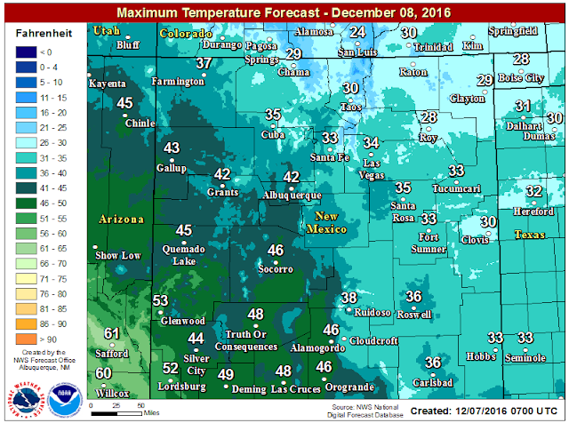
By late this afternoon a backdoor arctic cold front will have entered most of Southeastern New Mexico and nearby West Texas. Our high temperatures today locally will be close to 60ºF. Our highs on Thursday will be some 20 to 30 degrees colder with readings mostly in the 30's. Lows Thursday morning will be in the teens. This airmass set to invade us will be the coldest of the season thus far.
With low level upslope flow developing behind the front tonight and a weak upper level disturbance approaching we could see a mix of light wintry precipitation tonight into tomorrow morning. Light freezing rain, light freezing drizzle, and possibly mixed with or changing over to light snow will be possible. At this time significant accumulations are not forecast although there could be some slick spots on local highways.
New Mexico Forecast High Temps Thursday.
Local High Temperatures Thursday.
Local High Temperature Change On Thursday.
High temperatures on Thursday will be some 20 to 30 degrees colder than those of this afternoon.
New Mexico Low Temperature Forecast.
Valid Thursday Morning.
Valid Today Through 5 PM MST Friday.
Local Snowfall Forecast.
Valid Today Through 5 PM MST Friday.
The Truth Is Stranger Than Fiction!


Comments
Post a Comment
Your comments, questions, and feedback on this post/web page are welcome.