A White Christmas For New Mexico This Year!
Blog Updated At 2:59 PM MST Friday Afternoon.
Halfway Between Artesia And Roswell, NM. 12-22-2016.
Not only has this year been a bumper crop for needle grass, the tumbleweeds are doing great too. Tumbling tumbleweeds all over the place across Southeastern New Mexico after this summer rains. They pile up against anything facing west such as this fence line south of Roswell. Miles and miles of these things can be found along our north-south facing fences. The Sons Of The Pioneers came out with a song about them in 1944...Tumbling Tumbleweeds.
Heavy Rain Instead Of Heavy Snow Over The Sacramento Mtn's.
Chaves County.
Eddy County.
Lincoln County.
Otero County.
Chaves County.
Eddy County.
Lincoln County.
Otero County.
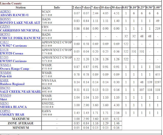
A rather remarkable event unfolded over the area the past two days. Heavy rains fell over the Sacramento Mountains of South-Central New Mexico. The Sierra Blanca Snotel located near Ski Apache at an elevation of 10,280' recorded a whopping 3.00" of rain out of this storm with only 2" of snow measured by the automated weather station! This is the second time this season that a heavy snow event was forecast and instead heavy rains fell instead in the Sacramento Mountains.
Ski Apache is off to a slow start for the season snowfall wise. They also only picked up 2" of snow from this two day storm with a base elevation of 9,600'. Their season total now stands at 9". Ski Cloudcroft isn't doing better with a base elevation of 9,100'. CocoRaHS Station 0.4 ESE of Cloudcroft is reporting a seasonal total of only 12.9" as of 8 AM this morning. Not one CoCoRaHS Station in Lincoln or Otero County reported any snowfall with this storm!
Some Of The Heavier 2-Day Rainfall Totals:
Sierra Blanca Snotel (10,280') 3.00"
Sacramento Peak (9,255') 2.45"
PWS Cloudcroft - DW7382 (8,698') 1.90"
PWS Mayhill - D7680 (7,178') 1.54"
Smokey Bear Raws - Ruidoso (7,090') 1.43"
PWS Weed - AT725 (6,988') 1.21"
PWS Timberon - C7724 (7,001) 1.35"
A relatively warm and extremely wet air mass at the mid levels of the atmosphere was pulled northeastward into Southern New Mexico ahead of the cutoff upper level low to our southwest as it moved northeast out of Baja, California. Temperatures across the Sacramento Mountains were some 5 to 10 degrees too warm for snow to fall even at the 10,000' elevation the past two days. Image if the temperatures had of been cold for snow. Take the rainfall totals above and convert them to snowfall totals using a 10 to 1 ratio, and snowfall totals across the Sac's would have been in the one to three foot range. Not this time however.
Who Gets A White Christmas This Year?
Valid At 11 PM MST Thursday, Dec 22, 2016.
NWS Watches & Warnings In Effect As Of 10:30 AM MST Friday Morning.
Click On This Link For The Latest Information.
NWS Storm Prediction Center (SPC)
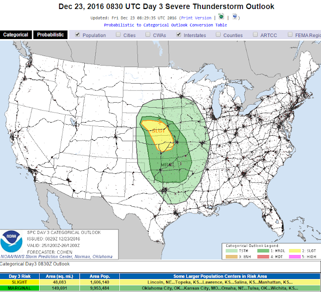
Severe Weather Outlook For Christmas Day!
Click On This Link For The Latest Information.
A dynamic a very strong winter storm is forecast to impact much of the Western and Northern US today into Christmas. Blizzard Watches have been issued for parts of the Dakotas with Winter Storm Watches and Warnings in effect for parts of the Western US. Severe Thunderstorms will be possible Christmas Eve and especially on Christmas Day for parts of the plains states. Additional Watches and Warnings will likely be issued between today and Monday so click on the links above for the very latest information concerning this impending significant winter storm from the National Weather Service Offices in your area of concern.
Much Colder & Stronger Winter Storm Headed To NM For Christmas.
Valid At 5 AM MST This Morning.
Valid At 5 PM MST Christmas Eve.
GFS 500 MB (18,000' MSL) Temperature Forecast.
Valid At 5 PM MST Christmas Eve.
Valid At 5 AM MST This Friday Morning.
A strong upper level winter storm is located over the far Pacific Northwest this morning is forecast to drop southward and into Central/Southern California by sunset Christmas Eve. Temperatures at the 500 millibar or 18,000' level with this storm are forecast to be fairly cold over Central California by sunset Christmas Eve. Temps of -30ºC/-22ºF are forecast which gives us a pretty indication that this next winter storm will have a punch to it. Compare these forecast temperatures with the upper air sounding at Albuquerque which showed a temperature at the 500 millibar or 18,000' MSL of -16.7ºC/2ºF. So the colder the winter storm is generally speaking the stronger it will be.
As just is about always the case with winter storms approaching New Mexico, who gets snow and how much is highly dependent upon the storm's track, speed, strength, and associated moisture. Who gets a White Christmas in New Mexico this year will fall into this category. As is usually the case the further south a winter storm drops into the Desert Southwest the better the chances for snow in New Mexico. Current forecasts as of 11 AM MST this Friday morning indicate that this storm will favor the Western and Northern one half of New Mexico for snow Christmas Eve night into Christmas. Any change in the storm's track will alter this forecast. If it goes further to the north then less snow will fall. A further south track would mean more snow for the state.
Both of this mornings computer forecast models (US GFS) and (European ECMWF) agree that the storm will drop south into Central California by sunset Christmas Eve. After that all three of the long range models (GFS,GEM,ECMWF) lift the storm northeastward fairly rapidly into South Dakota by sunset Christmas Day. Hence the Blizzard Watches in that area.
Valid At 5 PM MST Christmas Eve.
Taking a look at the US GFS Surface and precipitation type forecast map for the 4-Corners Region at sunset Christmas Eve we can see that a strong cold front associated with the upper level storm over Central California will be racing eastward across Central Arizona. With rain falling over the state at the lower elevations and snow in the high country, as well as northward into Nevada and Utah.
Winter Storm Head For Arizona First.
NWS Watches & Warnings In Effect As Of 11 AM MST Friday.
Click On This Link For The Latest Information.
Valid At 5 PM MST Christmas Eve.
Valid At 5 AM MST Christmas Morning.
Valid Christmas Day.
NWS NDFD Temperature Departure Forecast.
Valid Christmas Day.
NWS NSFD Forecast Storm Total Snowfall Amounts.
Valid Today Through 5 PM MST Christmas Day.
Computer model forecasts indicate that the Mountains of Western and Northern New Mexico should fair failry well as far as snowfall is concerned Christmas Eve night into Christmas Day. Some of the higher peaks could end up with a foot or more of new snow. Unless the storm comes a little further to the south than currently is forecast the Sacramento Mountains are only looking at a couple more inches of fresh powder from this storm.
So now the bad news. It does not currently appear that the Southeastern Plains of New Mexico will see a White Christmas this year. The storm to our west would have to drop down near a Tucson to El Paso line in order for this to happen. Current model forecasts do not indicate that this will occur.
So we are looking a mild but breezy day with our high temps Christmas Day in the 50's with a west wind gusting up into the 20-30 mph range in the afternoon. A High Wind Watch is in effect for the Guadalupe Mountains of Eddy and Culberson Counties from Christmas Eve night into Christmas Day for west winds of 30 to 50 mph with gusts to 65 mph.
The Truth Is Stranger Than Fiction!


Comments
Post a Comment
Your comments, questions, and feedback on this post/web page are welcome.