My Current Weather

Sunday, June 30, 2019

Continued Seasonably Hot - Best Chance For T-Storms Over The Mtns.


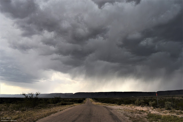
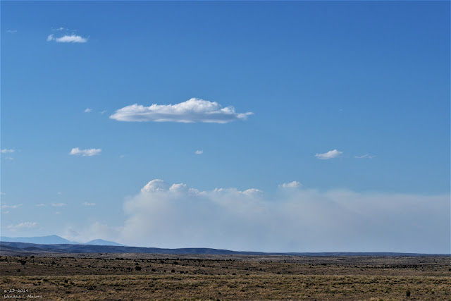
 June 26th, 2019.
Looking West Towards Washington Ranch Southwest Of Carlsbad, NM.

High based thunderstorms are common in New Mexico in the spring and sometimes early summer. Meaning that these storms often have cloud bases that are some 10,000' to 15,000' above the surface. This occurs when the low levels of the atmosphere are relatively dry. The result is often light rainfall if it manages to fall to the ground. If not then you see a lot of virga as in my photo above. Virga is precipitation streaks that falls from the clouds but evaporates before it reaches the ground. Virga is a common sight in New Mexico.

When Do The Summer Rains Begin?


Valid At Midnight Sunday, June 30th, 2019.

GFS 500 Millibar/18,000' MSL Winds Analysis.

Valid At Midnight Sunday, June 30th, 2019.

Last nights upper air soundings and analysis shows a ridge of high pressure at the mid and upper levels of the atmosphere camped out over the area. Winds aloft at around the 18,000' level are mostly out of the northeast over Southeastern New Mexico. With strong subsidence (sinking air) occurring under the ridge these winds are not steering any storms into our local area because there are any to do so anyway. 

A weak easterly wave is show moving westward in the Houston, Texas area. How far west or northwest this wave makes it this week will play a role in how much and where any summertime thunderstorms develop over the area.

Weather Prediction Center Total Rainfall Forecast.

Valid Today Through Next Sunday, July 7, 2019.

Current model forecasts aren't all that excited about a significant pattern change anytime soon. Typically our annual Monsoon kicks in around the 4th of July. Most of the models develop widely scattered to scattered thunderstorms later this week over the Sacramento mountains as well as the northern mountains and northeastern plains of the state. The rest of us locally will likely fall into the hit but mostly miss category. 


I'm not so sure that I agree with last nights run of the GFS model concerning the heavier rainfall forecast to over the area. This seems overdue to me. 

The Truth Is Stranger Than Fiction - And Sometimes It Hurts!

Friday, June 28, 2019

Hit & Miss T-Storms Thursday.


(As Of 5 AM MDT Friday, June 28th, 2019).

Cannon AFB Radar Estimates.


Holloman AFB Radar Estimates.


El Paso/Santa Teresa Radar Estimates.


Widely scattered to scattered thunderstorms developed over and near the mountains yesterday afternoon. These storms congealed into a complex that moved southeastward into the northern Pecos Valley of Southeastern New Mexico around midnight and afterwards.

Radar estimated some pockets of heavier rainfall from this activity although it was widely scattered in nature. The heaviest rains appear to have fallen just south of the Mayhill area with 1.00" to 3.00" possibly having drenched a small area. 

Tis the season of hit and miss thunderstorms. Those of us who manage to get lucky and get hit with one can get a decent rain while most will not get wet. 

The Truth Is Stranger Than Fiction - And Sometimes It Hurts!

Thursday, June 27, 2019

Some Rain Falls On The Pine Lodge Fire Today.


Pine Lodge Fire.


"The crew is leaving the Pine Lodge Fire in New Mexico and are on our way to Cloudcroft for a preposition due to the expected lightning the area is expecting over the next few days. These photos are from mostly backfiring operations on the Pine Lodge Fire. I'll add descriptions when I can, so sorry for the blank photo descriptions for now."

GRLevel3 2.00 Dual Pol Radar.
(Cannon AFB Radar).

Radar Estimated Rainfall Totals Today As Of 5 PM MDT.

Pine Lodge Fire Burn Area.


Flash Flood Warning For The Pine Lodge Fire Area Today.


Quote-

T"he National Weather Service in Albuquerque has issued a

* Flash Flood Warning for...
Southeastern Lincoln County in central New Mexico...

* Until 400 PM MDT.

* At 159 PM MDT, Doppler radar indicated thunderstorms producing
rain across the Pine Lodge burn area. Up to two tenths of an inch
of rain has already fallen and an additional one to two tenths of
an inch are likely. Flash flooding is expected to begin shortly.

* Flash flooding will impact Forest Service Roads 130 and 156,
drainages along State Road 246, Red Lick Canyon, and Kelly Canyon.

PRECAUTIONARY/PREPAREDNESS ACTIONS...

Runoff from rainfall will cause elevated water levels within
vulnerable drainage's in and downstream of the Pine Lodge fire burn
area."

This has to be one of the more interesting Flash Flood Warnings I've ever seen issued by the Albuquerque National Weather Service Office. Similar warnings were issued by this office during the Little Bear Fire in the Ruidoso area in June of 2012.

I grabbed a radar snapshot of the estimated rainfall that has fallen over the burn scar area today from the Cannon Air Force Radar. In the immediate vicinity of the burn area radar is estimating as of 5 PM that around .10" to .35" of rain has fallen. Thus prompting the flash flood warning. Sounds kinda of crazy right? Not so fast because when you burn off all of the vegetation in a hilly and mountainous area exposing bare rocky ground then it does not take much rainfall to create a flash flooding. 

The warning at 4 PM MDT stated that up to .20" of rain had fallen and another .10" to .20" of rainfall would create flash flood conditions. Wild stuff indeed. 

Radar also estimated that up to .75" may have fallen about five miles west of the fire and up to 2.00" 14 miles west of the fire just north and northeast of Capitan. These totals may be a little bit over estimated or too high compared to what may have actually have fallen. 

The Copeland Raws (IRAWS4) on the northeastern edge of the burn area (5,450') recorded .06" rainfall today as of 6 PM MDT. That's not much rain but its a start. 

Hit and miss thunderstorms are forecast over the fire area tonight through next Monday so with luck one or more of these storms will help extinguish the fire. 

As of today the Pine Lodge Forest Fire had consumed some 12,484 acres and was only 11% contained. The cause of the fire is still under investigation. 566 people are battling the fire. 

The Truth Is Stranger Than Fiction - And Sometimes It Hurts!

Tuesday, June 25, 2019

Hot Again With Widely Scattered T-Storms.


June 23rd, 2019.

My wife and I were on our way back home from a trip to Las Cruces this past Sunday afternoon when I took this photo of  a pyrocumulus cloud and smoke. We were just north of Dunken, in southwestern Chaves County, on US Hwy 82 looking back to the north at the Pine Lodge Fire.

As of late Monday evening this forest fire has already consumed 7,898 acres with 0% containment. The cause of this fire remains unknown and it started around 2 PM MDT on June 19th. 

Chance For T-Storms Today.


An Air Quality Alert remains in effect for today for Lincoln County because of smoke from the Pine Lodge Forest Fire. 

Widely scattered thunderstorms are forecast to pop up over the area this afternoon and evening with the best chances for storms across Eddy and Lea Counties. The Carlsbad and Hobbs areas has a 30% chance of getting wet. A few of these thunderstorms may be marginally severe and produce large hail and damaging thunderstorm wind gusts in excess of 60 mph.


High temperatures today will range from the upper 90's to near 100ĀŗF.


The strongest thunderstorms may dump up to an half of an inch of rain or so.

The Truth Is Stranger Than Fiction - And Sometimes It Hurts!

Thursday, June 20, 2019

Wednesday Was Hot - Today Will Be Even Hotter.


(Wednesday, June 19th, 2019).


Both the Carlsbad and Roswell Airports reported high temperatures yesterday of 102ĀŗF. It was 120ĀŗF yesterday in Death Valley


Forecast highs today across Southeastern New Mexico are expected to range from 101ĀŗF to 105ĀŗF. A few locations may get a little hotter. Forecast highs across West Texas are expected to range from 102ĀŗF to 108ĀŗF. A few locations may be hotter.

Similar readings are forecast for Friday.

The Truth Is Stranger Than Fiction - And Sometimes It Hurts!

Wednesday, June 19, 2019

Artesia Hailstorm Monday, June 17th, 2019.


A Severe Thunderstorm dropped quarter (1.00" diameter) to 1.25" diameter hail that covered the ground around 7:30 PM MDT Monday, June 17th. Several rounds of hail were observed. Heavy rain also accompanied the storm with radar estimating around 3.50" of rain having fallen 5-6 miles west-southwest of town just south of US Hwy 82.


A Personal Weather Station (PWS) measured 1.96" of rainfall in the center of town. Another classic example of how localized severe thunderstorms can be as well as their heavy rainfall and flash flooding. 


The Truth Is Stranger Than Fiction - And Sometimes It Hurts!

Monday, June 17, 2019

Chance For Severe T-Storms Today- Pinon Tornado 9-15-2016.


Severe Thunderstorm Outlook Today.


Latest Updated Outlook Available At 7 AM MDT.

Dew point temperatures have climbed up into the low to mid 60's early this morning with the dryline backed up against the east slopes of the Capitan, Sacramento, and Guadalupe mountains. Low level southeasterly upslope flow is producing a deck of stratocumulus over the Pecos Valley and Southeastern Plains this morning.

Just like that our chances for scattered thunderstorms popped back up overnight with the risk for marginal to severe thunderstorms this afternoon and evening. In yesterday's blog I mentioned that our chances for rain were pretty much over...not so fast. This just proves how our weather can change and how quickly it does so.

Thunderstorms are forecast to form over the mountains late this morning and early this afternoon and then drift eastward out over the Southeastern Plains and into West Texas by late this afternoon and evening. Large hail and damaging thunderstorm wind gusts will be the primary severe weather threats. Along with deadly cloud to ground lightning and locally heavy rainfall that could produce localized flash flooding. 

Winds aloft are fairly weak so the threat for tornadoes appears to be low. But remember severe thunderstorms can and sometimes do produce tornadoes with little to no advanced warning. 

Pinon Tornado.
(September 15th, 2016)


Pinon is a small ranching community located in the southeastern corner of Otero County at the foot of the Sacramento mountains. Pinon is southeast of Weed and Sacramento, and south-southeast of Mayhill and east of Timberon. Pinon's elevation is 6,020'.

I stumbled across this video yesterday while searching for additional videos of tornadoes that may have occurred near the Hope area on June 4th. Searching through the Storm Prediction Centers data base I can't find where this tornado was reported. Were there more tornadoes in and close to that area that afternoon? Did this tornado or others cause any damages? I'm thankful Mr. Gage shot the video because this just lends truth to what I've always said and believed in that we have more tornadoes in Southeastern New Mexico than most people think. They just go unreported and documented sometimes. 

In the blog I posted on June 15th I mentioned that there still remains a need for more Skywarn Spotters and better reporting of severe weather events such as this locally and across New Mexico. This once again proves that tornadoes do occur in and near the mountains of New Mexico.

 Remember radar does not and will not detect tornadoes. It detects the rotation within a severe thunderstorm that may lead to the development of tornadoes. Radar coverage over the Sacramento mountains is less than ideal. Ground truth information on what is really going on in a storm is always one of the key triggers for a warning or not. This is the role of the spotter. 


Two tornadoes were reported close by that afternoon. One 13 miles east-northeast of Dunken at 2:15 PM MDT and the second 1 mile west of Hope at 4:06 PM MDT. Although as my blog post from that day shows there were several more tornadoes that were well photographed and documented near Dunken and Hope that afternoon. Destructive hail also occured in the Atoka and Dayton areas south of Artesia. 4.00" diameter hail was reported from a separate severe thunderstorm at 10:18 PM MDT in Seven Rivers. 

The Truth Is Stranger Than Fiction - And Sometimes It Hurts!

Sunday, June 16, 2019

Goodbye Rain - Hello Heat.


Today.


Monday.


Tuesday.


Wednesday.


Thursday.


Friday.


For now our stormy weather comes to an end. We are leaving the average heart of our severe weather season as we head towards the end of this month. Does this mean that we can't have severe thunderstorms from here on out? Absolutely not. Severe thunderstorms have been documented just about every month of the year locally. We usually have a second severe weather season beginning around the end of August into the first of October. Without a doubt our spring was very active severe weather-wise and got off to an early start.

The heat machine is slated to crank up over the area over at least the next week if not beyond. Forecast high temperatures over the next week to ten days will be at or above 100ĀŗF. Next Friday looks to be the hottest day of the upcoming week with a forecast high temperatures in Carlsbad of 104ĀŗF. Don't be too surprised if we don't end up getting hotter than this. 

June typically sees the highest temperatures recorded locally. July, August, and September can be comparably miserable for us in some years because of the increased rainfall and humidity. Long range models aren't offering much hope for relief from the heat as far as rain is concerned either.


(Years With High Temps 108ĀŗF Or Above).

Roswell Airport.


Artesia Climate.


Carlsbad Climate.


Carlsbad Airport.


Hobbs Climate.


The Truth Is Stranger Than Fiction - And Sometimes It Hurts!

NWS Albuquerque Burn Scar Matrix Forecast

Current NWS Watches/Warnings In Effect

New Mexico

Eddy County

Chaves County Plains & Mtn's

Culberson County

Lea County

Lincoln County

Otero County

Current US Temps

Current US Wind Chill/Heat Index Temperatures

NWS Midland Forecast

NWS Albuquerque Forecast

NWS Albuquerque Forecast

NWS El Paso Forecast

NWS Lubbock Forecast

NWS Lubbock Forecast

Average Daily High/Low Temperatures & Rainfall

Average Daily High/Low Temperatures & Rainfall