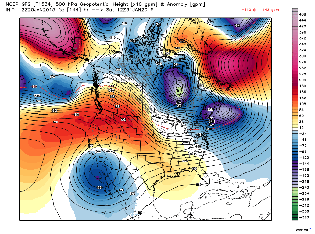
My Current Weather

Friday, January 30, 2015

Moderate To Heavy Rains Tonight Into Saturday.


HRRR Rainfall Total Forecast.
Valid @ 5 AM MST.

RAP Rainfall Forecast.
Valid @ 9 AM MST Saturday.

NAM-WRF Rainfall Forecast.
Valid @ 5 PM MST Saturday.

NCEP NDFD Rainfall Forecast.
Valid @ 5 PM Saturday.


An additional 2" - 5" of snow above 7,500'.
An additional 6" - 12" of snow above 8,500'.


An additional 1" - 4" of snow below 7,000'.
An additional 4" - 8" above 7,000'.

An approaching disturbance from northern Mexico will ramp up the rains across southern New Mexico, southeastern New Mexico, and parts of West Texas after sunset. Generally rainfall totals by sunset Saturday should be in the .50" - 2.00" range across the area. A rather rare event for January.

The Truth Is Stranger Than Fiction!

Latest Potent Winter Storm Underway In New Mexico.


Time For America To Have A Reality Check 
Concerning (Global Warming) Climate Change. 


Latest Update On Our Ongoing Winter Storm.


24-Hour Rainfall & Snowfall Forecasts.


Thursday, January 29, 2015

Lessons To Be Learned From The Blizzard Of 2015 - Heavy Rain & Snow Coming To New Mexico.


There is a powerful lesson to be learned from the Blizzard of 2015! That lesson is that no matter how good we think we are at forecasting the weather, in reality, more often than not, we're not that good at times. Yes we've come a long way in the past few years compared to say 20, 30, 50 years ago with computer model forecasting. But make no mistake Mother Nature still rules in this department. 

The great Blizzard of 2015 tracked just a mere 80 miles east of  the models forecasts and missed New York City but buried parts of New England. Making a fool out of many a forecaster, and politician...that's the nature of the business when dealing with weather forecasting. Just remember that at some point in time, more often than not, even the best of the best forecasters will be wrong. I'm not one to criticize the National Weather Service when their forecasts bust sometimes. Nobody's perfect and God knows they give it their best. I do find it troubling that our politicians and media go to great lengths to hype these winter storms (hurricanes, tornadoes, floods, etc) for their political gain. In my opinion this is unethical and morally wrong!

 Long ago (October 1976) on my first day of class during my U.S. Navy Aerographer's Mate Weather Observing School our instructor wrote this on the blackboard: "Meteorology is the most inexact science there is"...and its still true today. 

Politicians Can Never Win With Weather:"After being a promised a blizzard of historic and catastrophic proportions on Monday, New York City residents woke up today to rather meager snow totals and a lot of questions for their public officials."

Yet the Political Far Left Liberals, the Extreme Environmentalists, Mother Earth Worshipers, and Global Warming Worshipers, all want you and I to believe that mankind is destroying the planet via Man Made Global Warming (disguised as Climate Change now). Really? We can't even accurately forecast the weather five days sometimes five hours in advance, much less 1 - 100 years down the road. Wake Up America We Are Being Lied Too By These Delusional Fools. 


12Z/5 AM MST GFS (T1534) 500 MB Forecast.
Valid @ 18Z/11 AM MST Saturday.

Tuesday, January 27, 2015

Cold-Sloppy Superbowl Weekend Coming Up.


This Mornings 12Z/5 AM MST GFS (T1534) 500 MB Forecast.
Valid @ 5 PM MST Saturday.


GFS (T1534) 6-Hourly Accumulated Snowfall Forecast.
Valid @ 5 PM MST Sunday.

GFS (T1534) Total Precipitation Forecast.
Valid @ 5 PM MST Sunday.


Cannon AFB - Clovis, NM.

Roswell, NM.

Sierra Blanca Regional Airport - Ruidoso, NM.

Artesia, NM.

Carlsbad, NM.

Hobbs, NM.


How about a sloppy, wet, snowy, cold Super Bowl weekend for southeastern New Mexico and surrounding areas? This appears to be our forecast starting Thursday night and continuing into Sunday at least. This upcoming storm is showing a lot of resemblance to the last storm we endured. The question is whether or not it will get cold enough to produce significant accumulating snows in the lower elevations of southeastern New Mexico. No doubt the mountains could once again get clobbered with 1' - 2' (feet) of the white stuff. 

I don't doubt that we will see snow, will it be cold enough to stick will be the question. Last nights GFS model run says yes with generally 3" - 6" of snow in the Pecos Valley. Along with the possibility of storm total rainfall amounts (rain & melted snow) of 1" - 2". 

The Truth Is Stranger Than Fiction!

Sunday, January 25, 2015

Yet Another Potentially Strong Winter Storm For NM Next Weekend.


This Mornings 12Z/5 AM MST
 GFS (T1534) 500 MB Forecast.
Valid @ 5 AM MST Saturday, January 31, 2015. 

This Mornings 12Z/5 AM MST
 Canadian (GEM) 500 MB Forecast.
Valid @ 11 AM MST Saturday, January 31, 2015. 


This Mornings 12Z/5 AM MST GFS (T1534) 
Total Precipitation (Rainfall) Forecast.
Valid @ 5 PM MST Saturday, January 31, 2015. 


This Mornings 12Z/5 AM MST GFS (T1534) 
Accumulated Snowfall Forecast.
Valid @ 5 PM MST Saturday, January 31, 2015. 

This Mornings 12Z/5 AM MST Canadian (GEM) 
Accumulated Snowfall Forecast.
Valid @ 5 PM MST Saturday, January 31, 2015. 


Carlsbad, NM.

Hobbs, NM.

Sierra Blanca Regional Airport - Ruidoso, NM.

First Look At Our Next Winter Storm. 

By this time next weekend New Mexico may once again be dealing with a strong winter storm. Interestingly enough it appears (for now anyway) that our temperatures here in southeastern New Mexico may be on the border (just above freezing), so this could be all heavy rain for us. Or if the Canadian model is forecasting, this may be another heavy snow event for parts of the area.

The trend this winter has been for these storms to dig further to the south than the models initially forecast. Time will tell if this one follows that trend. Either way it looks like a very wet storm. One way or the other it appears that the Guadalupe, Sacramento, Capitan and other mountains ranges in teh state are in for more heavy snows. 

The Truth Is Stranger Than Fiction!

Friday, January 23, 2015

New Mexico Snowfall Summary 1-23-2015.

Blog Updated @ 6:00 PM MST.

I don't think that our soon to be two year old grandson (Kason Kole Levario)
 was enjoying the snow in Artesia yesterday nearly as much as I was.
 Photo is courtesy of our oldest daughter Amanda Levario.


My two day storm total snowfall here at our home in Carlsbad is 4.2". The maximum snow depth on the ground was this morning with 1.5". This was a wet snow with very large flakes at times, and other times tiny snowflakes fell. Most of which melted as it fell. Including the rain that fell my liquid storm total precipitation is .44" which brings my January total to 1.02". My high temp yesterday was 34°F.

Several reports from Artesia indicated that 4" - 4.5"Additional snowfall totals are available via CoCoRaHS. Click On "The Read More Link" To View A Statewide listing of snowfall totals.

Thursday, January 22, 2015

Snowstorm Underway In New Mexico.

Blog Updated @  5:04 PM MST.

NM Roads Mobile App.

Local Snowfall Reports-

Cloudcroft 11"
W Roswell 8" & 13" Drifts
Queen 8"
7 E Cloudcroft 7"
1 WNW Mescalero 7"
Midway SE Of Roswell 7"
Roswell 6"
Runyan Ranches East Of Elk 5" With 8" Drifts
Artesia 4"
Hope 4"
NW Carlsbad 3.1"
(Max Depth 1" at 5 PM Due To Melting)
Atoka 2"
Brantley Lake 1/2"


(Last Updated @ 2:42 PM MST).

• 5 S Edgewood - 16.0 in.
 • 5 SW Bonito Lake - 15.0 in.
 • 3 NE Bonito Lake - 14.0 in.
 • 6 WSW Bonito Lake - 14.0 in.
 • 1 ESE Sedillo - 14.0 in.
 • 1 ESE Sedillo - 14.0 in.
 • Tijeras - 13.5 in.
 • 7 WSW Roy - 13.0 in.
 • 3 ESE Angel Fire - 13.0 in.
 • 3 ENE Ponderosa - 13.0 in.
 • 4 NE Tijeras - 13.0 in.
 • 5 E Tijeras - 12.5 in.
 • Sugarite - 12.0 in.
 • 2 S Roy - 12.0 in.
 • 13 NW Estancia - 12.0 in.
 • 2 WSW Edgewood - 12.0 in.
 • 2 E San Antonito - 11.9 in.
 • 1 WSW Sedillo - 11.6 in.
 • 8 S Tijeras - 11.5 in.
 • 8 NE Arroyo Seco - 11.0 in.
 • 9 ESE Solano - 11.0 in.
 • Torreon - 11.0 in.
 • 1 S Sandia Park - 11.0 in.
 • 2 WNW Ponderosa - 10.0 in.
 • 2 SE Manzano - 10.0 in.
 • 2 NW Sedillo - 10.0 in.
 • 8 NW Mountainair - 10.0 in.
 • 2 SSW Alto - 10.0 in.
 • Tijeras - 9.5 in.
 • Capitan - 9.5 in.
 • 8 SW Rociada - 9.0 in.
 • 8 SSW Red River - 9.0 in.
 • 4 E Sandia Park - 9.0 in.
 • 2 ESE Roy - 9.0 in.
 • 15 SSE Mosquero - 9.0 in.
 • Ruidoso - 9.0 in.
 • 6 E Rociada - 8.8 in.
 • 4 E Sandia Park - 8.8 in.
 • 2 E Sedillo - 8.7 in.
 • 1 W Tesuque - 8.7 in.
 • 1 ESE Truchas - 8.6 in.
 • House - 8.5 in.
 • 1 SSW Tijeras - 8.5 in.
 • 4 N Tucumcari - 8.5 in.
 • Conchas Dam - 8.0 in.
 • Tesuque - 8.0 in.
 • 4 NW Sandia Park - 8.0 in.
 • 8 SW Wagon Mound - 8.0 in.
 • Valmora - 8.0 in.
 • Folsom - 8.0 in.
 • 3 SSW Amistad - 8.0 in.
 • Tijeras - 8.0 in.
 • 5 SSE Llano Largo - 8.0 in.
 • 18 E Corona - 8.0 in.
 • 1 W Vaughn - 8.0 in.
 • 6 ENE Arabela - 8.0 in.
 • 7 ESE Chupadero - 8.0 in.
 • 2 SSW Angel Fire - 8.0 in.
 • 8 SE Eagle Nest - 8.0 in.
 • 1 E Portair - 7.5 in.
 • 9 W San Rafael - 7.5 in.
 • 1 S Mountainair - 7.5 in.
 • 5 N Pleasant Hill - 7.5 in.
 • 3 W Logan - 7.1 in.
 • 8 WNW Abiquiu - 7.0 in.
 • 1 SSE Dilia - 7.0 in.
 • 5 ESE Tucumcari - 7.0 in.
 • 4 NW Tucumcari - 7.0 in.
 • 4 NNE Sandia Park - 7.0 in.
 • 2 NW El Rito - 7.0 in.
 • Bueyeros - 7.0 in.
 • 13 E Gladstone - 7.0 in.
 • 6 W Los Alamos - 7.0 in.
 • 1 NNW Romeroville - 6.9 in.
 • 2 W Santa Cruz - 6.7 in.
 • 3 SE Las Vegas - 6.5 in.
 • 3 NE Tucumcari - 6.5 in.
 • 10 SSE Angel Fire - 6.2 in.
 • 4 NNW Tres Ritos - 6.0 in.
 • 1 SE Roswell - 6.0 in.
 • 1 E Los Alamos - 6.0 in.
 • Cowles - 6.0 in.
 • 11 SE Cedarvale - 6.0 in.
 • 1 NW Roswell - 6.0 in.
 • 7 ESE Cuba - 6.0 in.
 • Tres Ritos - 6.0 in.
 • 6 WNW Tererro - 6.0 in.
 • 11 NW Sedan - 6.0 in.
 • Coyote - 6.0 in.
 • 10 NW Newkirk - 6.0 in.
 • Santa Rosa - 6.0 in.
 • Springer - 6.0 in.
 • 1 E Arroyo Seco - 5.6 in.
 • 2 SSW Embudo - 5.5 in.
 • 4 NNW Edgewood - 5.5 in.
 • 5 S Cedarvale - 5.0 in.
 • 2 E Elk - 5.0 in.
 • 1 NNE Velarde - 5.0 in.
 • Des Moines - 5.0 in.
 • 8 WNW Farley - 5.0 in.
 • Roswell - 5.0 in.
 • 24 SSE Yeso - 5.0 in.
 • Holman - 5.0 in.
 • 4 SSE Clovis - 5.0 in.
 • Wheatland - 5.0 in.
 • 5 ESE Red River - 5.0 in.
 • 11 WSW Bluewater Lake - 5.0 in.
 • Los Alamos - 5.0 in.
 • 11 ENE Amalia - 5.0 in.
 • 8 SSW San Miguel - 5.0 in.
 • 9 E Cuba - 5.0 in.
 • 2 NE Clovis - 5.0 in.
 • 2 WNW Clovis - 5.0 in.
 • 1 N Milan - 5.0 in.
 • 4 NW Santa Fe - 5.0 in.
 • 1 E White Rock - 4.7 in.
 • 15 SSW Clayton - 4.5 in.
 • 2 WNW Clayton - 4.5 in.
 • 4 NNW Santa Fe - 4.5 in.
 • Cimarron - 4.5 in.
 • Eagle Nest - 4.5 in.
 • 1 W Grants - 4.3 in.
 • 2 SSE Taos - 4.2 in.
 • Angel Fire - 4.0 in.
 • 11 ENE Red River - 4.0 in.
 • 4 SW Mcintosh - 4.0 in.
 • 3 SSW Encino - 4.0 in.
 • Fort Sumner - 4.0 in.
 • 4 NE Alcalde - 4.0 in.
 • 5 WNW Los Alamos - 4.0 in.
 • 9 ENE Shady Brook - 4.0 in.
 • Portales - 4.0 in.
 • 11 NNW Canon Plaza - 4.0 in.
 • 5 NW Canones - 4.0 in.
 • 7 E Canjilon - 4.0 in.
 • 2 SE Abiquiu - 4.0 in.
 • 1 SW Fort Sumner - 4.0 in.
 • 7 NNW Agua Fria - 4.0 in.
 • 4 NNE Roswell - 3.8 in.
 • 3 NW Santa Fe - 3.5 in.
 • 2 WNW Corrales - 3.5 in.
 • Acoma Pueblo - 3.5 in.
 • Raton - 3.5 in.
 • 1 N Moriarty - 3.5 in.
 • 2 NE Placitas - 3.4 in.
 • 1 NNE Corrales - 3.4 in.
 • 1 WSW Santa Fe - 3.4 in.
 • 1 ESE Medanales - 3.3 in.
 • 3 NW El Prado - 3.3 in.
 • 1 ENE Corrales - 3.2 in.
 • Stanley - 3.0 in.
 • 5 SSW Toadlena - 3.0 in.
 • 2 NW Edgewood - 3.0 in.
 • 2 E Estancia - 3.0 in.
 • 1 SE Espanola - 3.0 in.
 • 2 SSW Los Cordovas - 3.0 in.
 • 1 ESE Corrales - 3.0 in.
 • 7 N Pleasant Hill - 3.0 in.
 • 6 WNW Espanola - 2.9 in.
 • Rio Communities - 2.8 in.
 • Angel Fire - 2.5 in.
 • 1 NNE Youngsville - 2.5 in.
 • 3 SW Rio Rancho - 2.5 in.
 • 6 NNW Jemez Pueblo - 2.5 in.
 • 2 SW Agua Fria - 2.3 in.
 • 3 SSW Santa Fe - 2.1 in.
 • Bingham - 2.0 in.
 • 2 WSW Rio Rancho - 2.0 in.
 • 5 E Albuquerque - 2.0 in.
 • San Fidel - 2.0 in.
 • 1 SSE Cochiti Lake - 2.0 in.
 • 8 NNW Glorieta - 2.0 in.
 • 1 SSW Milan - 2.0 in.
 • 1 SW Placitas - 2.0 in.
 • Datil - 2.0 in.
 • 7 E Albuquerque - 1.8 in.
 • 4 WSW Rio Rancho - 1.8 in.
 • 6 SSE Santa Fe - 1.7 in.
 • 8 ENE Albuquerque - 1.5 in.
 • Carrizozo - 1.5 in.
 • 3 NE Rio Rancho - 1.5 in.
 • Alamo - 1.5 in.
 • 8 W Sandia Park - 1.5 in.
 • 2 W Datil - 1.5 in.
 • 5 NW Lamy - 1.5 in.
 • 4 ESE Albuquerque - 1.5 in.
 • 8 ESE Albuquerque - 1.3 in.
 • 3 N Lamy - 1.3 in.
 • 4 NNW Lamy - 1.2 in.
 • 2 SE Albuquerque - 1.1 in.
 • 4 NW Lamy - 1.1 in.
 • 2 W Corrales - 1.0 in.
 • 4 SE Chaco Canyon - 1.0 in.
 • 2 WSW El Morro - 1.0 in.
 • Quemado - 1.0 in.
 • 3 SW Magdalena - 1.0 in.
 • Natl Radio Astronomy Obs - 1.0 in.
 • 6 ESE Mogollon - 1.0 in.
 • 8 ENE Albuquerque - 1.0 in.
 • 6 NNW Guadalupita - 1.0 in.
 • 13 NW Taos - 0.9 in.
 • 4 SSE Albuquerque - 0.8 in.
 • 6 SSE Santa Fe - 0.8 in.
 • 4 SE Albuquerque - 0.8 in.
 • 2 E Albuquerque - 0.7 in.
 • 5 NE Albuquerque - 0.6 in.
 • 3 W Rio Rancho - 0.5 in.
 • 2 ENE Gallup - 0.5 in.
 • Laguna Pueblo - 0.5 in.
 • Santa Fe - 0.3 in.
 • Luna - 0.3 in.
 • Chama - 0.3 in.
 • 5 NW Lamy - 0.2 in.
 • 2 NNE Questa - 0.2 in.
 • 3 NNE Albuquerque - 0.2 in.
 • 8 NNW Omega - 0.1 in.

NWS Albuquerque Burn Scar Matrix Forecast

Current NWS Watches/Warnings In Effect

New Mexico

Eddy County

Chaves County Plains & Mtn's

Culberson County

Lea County

Lincoln County

Otero County

Current US Temps

Current US Wind Chill/Heat Index Temperatures

NWS Midland Forecast

NWS Albuquerque Forecast

NWS Albuquerque Forecast

NWS El Paso Forecast

NWS Lubbock Forecast

NWS Lubbock Forecast

Average Daily High/Low Temperatures & Rainfall

Average Daily High/Low Temperatures & Rainfall