My Current Weather

Tuesday, November 29, 2022

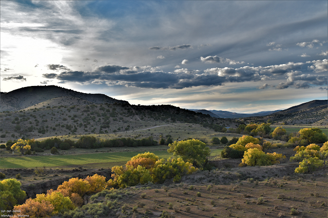
High Winds Already Cranking Up This Morning.

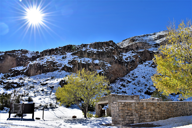
November 26, 2022.
Looking West From US Hwy 62/180.
Just South Of The Carlsbad, NM Airport.

Our daughter and husband were on top of C-Hill Friday night around 10 PM and noted that snow was starting to stick to the ground. C-Hill is just a couple hundred feet higher than home about 1/2 of a mile due east and at an elevation of 3.158'. We had light rain and light snow mixed at the same time at our home. In the photo above this slight difference in elevation is noted by the snow on the foothills in the background. See my blog post on 11-27-2022 for snowfall reports and photos.

(AS Of  11:59 PM MST Tuesday, Nov 29, 2022).


Sunday, November 27, 2022

Black Friday Winter Storm Summary 11-27-2022.


November 26, 2022.
Sitting Bull Falls Recreation Area
42 Miles West Of Carlsbad, New Mexico.

Blog Updated Sunday, Nov 27th, 2022 At 6:00 PM MST.
Blog Updated Monday, Nov 28th, 2022 At 7:00 AM MST.
Blog Updated Tuesday, Nov 29th, 2022 At 9:05 AM MST.
Blog Updated Friday, Dec 2nd, 2022 At 7:11 PM MST.
Blog Updated Sunday, Dec 24th, 2022 At 8:18 AM MST.

Stunningly beautiful does not come close to describe my drive up to Sitting Bull Falls (elevation 5,000') Saturday morning from Carlsbad. I also shot video of the drive up on my Go Pro Camera and I will share that video when I get done editing. 

This has to have been one of the craziest acting snow events I've seen in my lifetime here in Eddy County and the rest of Southeastern New Mexico. And I am 64 years old. I've seen other rain/snow mixed events like this one in the past but none to this extreme. Hard to believe that Queen at 5, 843' got 18" to 20" of snow while Cloudcroft further to the northwest in the Sacramento mountains at 8,750' measured 7.0" from the storm.

Light rain started falling in Carlsbad late Thanksgiving afternoon and evening. By around 2 AM Friday morning it had started mixing with and at times changing over to snow here at our home. A steady cold rain moderate to heavy at times fell continuously from Thanksgiving night through 5:30 AM Saturday morning. All through the day Friday into early Saturday morning we saw this back and forth mix of rain and snow. Sometimes all rain and sometimes all snow. Heavy wet snow with huge snowflakes few Friday morning accumulating to 1/2 of an inch on the ground at our home in Carlsbad. But by noon it was gone. My storm total precipitation for the event was 1.38" with 0.5" of snowfall. My family in Atoka south of Artesia reported 1.48" and a 1/2 of an inch of snow.

My high temp on Friday was only 35º and whenever the temp dropped a degree or two the rain changed over to or mixed with snow. Now here is the really weird part. Carlsbad Caverns National Park located 16 miles southwest of Carlsbad and 1,200' higher up in elevation measured 12.0" of snow! With drifts occurring as well. But by far the biggest winner was Queen located 50 miles west-southwest of Carlsbad at an elevation of 5,843'. They measured 18"-20" of snow! The Mobley Ranch located east of Loving and southeast of Carlsbad measured 6"-8" of snow. Locations up and down, east and west of the Pecos Valley only a couple of hundred feet higher in elevation picked up anywhere from 4" to 12"+ of snow. While the Roswell, Artesia, and Carlsbad areas had less than an inch. That slight difference in elevation combined bit a couple of degrees of colder temps made all of the difference in the world. 

Local Storm Total Snowfall Reports.

Queen RV Part & Restaurant 18.0" - 20.0" Mayhill 13.0"
Weed/Sacramento12.0"
Elk NWS Climate Co-Op Station 12.0"
11 miles east of Cloudcroft on US Hwy 82 (MM 29) 12.0"
Runyan Ranches east of Elk on US Hwy 82 (MM 56) 12.0"
Weed/Sacramento12.0"
Mayhill 2.8 miles west-northwest 11.5"
Sierra Blanca Snotel Near Ski Apache 11.0"
Wimsatt area east of Cloudcroft 11.0"
Elk NWS Climate Co-Op Station 11.0"
Mayhill 2.8 miles west-northwest 10.5"
16 Springs Canyon east of Cloudcroft 10.0"
Arabella 2.5 miles south-southwest 9.0"
White Oaks 6 miles west-northwest 9.0"
Caprock NWS Climate Co-Op Station 8.0"
Cloudcroft 2.3 miles south 7.0"
Cloudcroft NWS Climate Co-Op Station 7.0"
Hope NWS Climate Co-Op Station 6.8"
5 miles east of Cloudcroft 6.0"- 8.0"
Mobley Ranch Southeast Of Carlsbad 6.0" - 8.0"
Young Canyon near Wimsatt, east of Cloudcroft 6.0"
Hibbard Ranch northeast of Pinon in southwest Chaves Co 6.0"

Cloudcroft 0.4 miles east-southeast 5.0"
.
Hope 25.9 miles west-southwest 3.0"
Ruidoso 5.6 miles north-northeast 2.8"
Nogal 4.6 miles south-southeast 1.7"
Cloudcroft 1.8 miles southwest 1.4"
Brantley Dam NWS Climate Co-Op Station 0.5"
2.1 NNW Downtown Carlsbad CoCoRaHS Station 0.5"
La Luz (Otero Co) 5.8 miles east-northeast 0.1"

(Saturday, Nov 26, 2022).

Monday, November 21, 2022

Just In Time For The Thanksgiving Holidays - A Winter Storm.

November 21, 2022.
Carlsbad, New Mexico.

Dense freezing fog blanketed the area this morning before burning off just before noontime. Local airports reported visibilities at or below 1/4 of a mile. A repeat is possible again tonight across parts of Southeastern New Mexico and parts of West Texas.

Our latest bout with winter produced 5.9" of snow 4.6 miles south-southeast of Nogal, 5.0" at Ski Apache, 5.0" 5.7 miles southwest of Capitan, 4.1" 5.6 miles north-northeast of Ruidoso, 4.0" 4.3 miles west-southwest of Capitan, 3.0" 0.3 miles north of Alto, and 1.9" 2.9 miles southwest of Ruidoso, and 1.2" was measured 2.5 miles south-southwest of Arabela. 0.7" was measured 0.4 miles east-southeast of Cloudcroft. and 0.5" was measured 4.0 miles east of Cloudcroft. Roswell, Artesia, Carlsbad, Hobbs, and Midland/Odessa all saw a trace of light snow.

A Personal Weather Station (PWS) Bell Canyon) located northwest of Mayhill recorded a low this morning of 8ºF. The Angel Fire Airport recorded a low this morning of -3ºF and Saturday morning while they noted -4ºF Sunday morning. 

Sunday, November 13, 2022

Wednesday, November 9, 2022

Wednesday, November 2, 2022

Near 80 Today - Windy Thursday - A Freeze Saturday Morning For SE NM?


October 30, 2022.
Looking SW At Sierra Blanca Peak From Nogal, NM.

(At 7 AM MDT Wed, Nov 2, 2022).


Cold air has progressively been getting colder with time across northern and central Alaska and the northwestern half of Canada. Time to start watching these areas for arctic cold fronts moving south into the US. Many locations this morning are in the single digits with some negative temps noted.


At 8 :31 AM MDT This Wednesday Morning.

Once again low clouds and pockets of fog developed overnight in Southeastern New Mexico and West Texas. Yesterday morning the visibility dropped below 1/4 of a mile in the Carlsbad and Hobbs areas. This morning (as of 8:45 AM MDT) the visibility in the fog has dropped down to 1/2 of a mile at the Roswell Airport, and less than 1/4 of a mile at the Artesia and Carlsbad Airports. The Hobbs Airport was reporting 3 miles in fog.

Breezy Today - Windy Thursday & Friday.


Valid At Noon MDT Thursday.

ECMWF 500 MB (18,000') Analysis.

At Midnight Wednesday Night.

ECMWF 500 MB (18,000') Forecast.

Valid At 6 AM MDT Thursday.

ECMWF 500 MB (18,000') Forecast.

Valid At 6 AM MDT Friday.

Our next storm in line was located near Seattle, Washington at midnight last night. This mid-level storm will drop south into southern Nevada by sunrise Thursday morning. Then the storm swings northeast into northern New Mexico by sunrise Friday morning. 


Valid At 6 PM MDT Thursday Evening.

A Pacific cold front will sweep eastward across New Mexico on Thursday. Moving through Southeastern New Mexico and West Texas Thursday night and Friday morning.


Today.


Thursday.


Friday.


NWS NDFD Low Temp Forecast.

Saturday.


Ahead of the incoming storm and cold front we will see our high temps today reach up into the upper 70's to near 80 across the Southeastern Plains. Thursday's highs will be in the mid to upper 70's. Highs across the local area on Friday will be near 60 to the low 60's. Lows Saturday morning will be mid 30's...perhaps colder along with the possibility of a freeze.

Highs today in the Ruidoso area will be near 60 and highs on Thursday will be in the mid 50's. Highs on Friday will be near 40 to the low 40's. Lows Saturday morning will be in the mid 20's.

The Cloudcroft area will see highs today in the upper 40's to near 50 and highs on Thursday will be in the mid 40's. Highs on Friday will be near 30 in the Cloudcroft area. Lows Saturday morning will be in the upper teens to near 20.


As the storm crosses New Mexico on Thursday strong jet stream winds at the 30,000' level (140 knots/161 mph) will aide in strengthening the low-mid level winds across New Mexico. 

Southwest winds will increase across the lowlands of southern New Mexico, the Southeastern Plains, and parts of West Texas on Thursday to sustained speeds of 2-25 mph with gusts to 30-40 mph. These winds will shift around to the west on Friday and gust up into the 30-40 mph range.

Across the Sacramento mountains southwest winds will increase to sustained speeds on Thursday and Thursday night to 25-35 mph with gusts to 45-55 mph. Westerly winds on Friday will gust up to around 30-40 mph. 

Localized areas of blowing dust will be possible Thursday afternoon and evening. 


NWS NDFD Storm Total Snowfall Forecast.


Snowfall with this storm will be limited to the western and northern mountains for the most part. At least the heaviest accumulating totals. Winter Weather Advisories are in effect for parts of the northern mountains from midnight tonight through noon on Friday. 

There is a slight chance for light snow showers across the higher elevations of the Sac's on Friday. Since the center of this storm will be north of us and given that it is a dry storm this should be a non snow producer.

There Are None So Blind As Those Who "Will - Not" To See...107.

NWS Albuquerque Burn Scar Matrix Forecast

Current NWS Watches/Warnings In Effect

New Mexico

Eddy County

Chaves County Plains & Mtn's

Culberson County

Lea County

Lincoln County

Otero County

Current US Temps

Current US Wind Chill/Heat Index Temperatures

NWS Midland Forecast

NWS Albuquerque Forecast

NWS Albuquerque Forecast

NWS El Paso Forecast

NWS Lubbock Forecast

NWS Lubbock Forecast

Average Daily High/Low Temperatures & Rainfall

Average Daily High/Low Temperatures & Rainfall