


Just In Time For The Thanksgiving Holidays - A Winter Storm.

Carlsbad, New Mexico.
Dense freezing fog blanketed the area this morning before burning off just before noontime. Local airports reported visibilities at or below 1/4 of a mile. A repeat is possible again tonight across parts of Southeastern New Mexico and parts of West Texas.
Our latest bout with winter produced 5.9" of snow 4.6 miles south-southeast of Nogal, 5.0" at Ski Apache, 5.0" 5.7 miles southwest of Capitan, 4.1" 5.6 miles north-northeast of Ruidoso, 4.0" 4.3 miles west-southwest of Capitan, 3.0" 0.3 miles north of Alto, and 1.9" 2.9 miles southwest of Ruidoso, and 1.2" was measured 2.5 miles south-southwest of Arabela. 0.7" was measured 0.4 miles east-southeast of Cloudcroft. and 0.5" was measured 4.0 miles east of Cloudcroft. Roswell, Artesia, Carlsbad, Hobbs, and Midland/Odessa all saw a trace of light snow.
A Personal Weather Station (PWS) Bell Canyon) located northwest of Mayhill recorded a low this morning of 8ºF. The Angel Fire Airport recorded a low this morning of -3ºF and Saturday morning while they noted -4ºF Sunday morning.
A Personal Weather Station (PWS) Bell Canyon) located northwest of Mayhill recorded a low this morning of 8ºF. The Angel Fire Airport recorded a low this morning of -3ºF and Saturday morning while they noted -4ºF Sunday morning.

ECMWF 500 Millibar (18,000') Forecast.

Canadian Gem 500 Millibar (18,000') Forecast.

Potential For A Major Winter Storm Thanksgiving Into The Holiday Weekend.

Saturday Evening At Sunset.
After taking a look at the latest computer model forecasts this morning the one thing that appears fairly certain is that a winter storm will be arriving in the Land of Enchantment just in time for the Thanksgiving holidays.
All three long-range computer forecast models (US GFS, European ECMWF, Canadian GEM) forecast a strong mid-level short wave trough of low pressure to develop over the southeastern Gulf of Alaska tomorrow. Then this storm dives southeastward into the Great Basin on Wednesday. By Thanksgiving day a closed mid-level low drops southward into New Mexico.
What happens after that is still up in the air. The US GFS model has the center of the closed low southeast of El Paso by sunset Thanksgiving evening. The European model has it centered near the Midland/Odessa area. And the Canadian model hangs it back further west as a stronger storm centered west of El Paso by sunset on Thanksgiving. How strong, and how far west/south the storm centers itself matters concerning the potential impacts upon the state and surrounding areas. Also how slow or how fast the storm exits the area will impact the snowfall amounts and where.
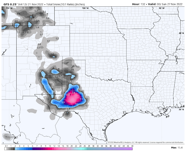
A slower and stronger moving storm as indicated by the Canadian model centered further west or southwest of El Paso Thanksgiving night would have major impacts upon the state and area. By far the Canadian model has the most widespread impacts across New Mexico with heavy snows that could cause major travel issues. If this model forecast turns out to be correct then some locations over and east of the northern and central mountains eastward into the plains could see near to, or blizzard conditions. But again this is a far stretch this far out in time at this point so we will have to wait for more information and later updates.
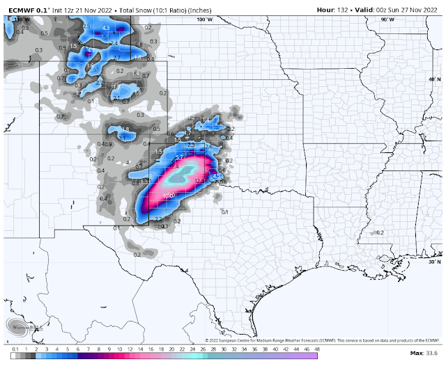
If the US GFS and European models are correct then lesser impacts would be felt upon the state. A strong cold front will drive southward through the state Wednesday into Wednesday night with strong gusty northly winds along and behind it.
Caution is strongly advised at this point since it is early in the game. All of these potential outcomes may, and likely will change, as new model runs and forecasts become available over the next couple of days. We are going to have a holiday winter storm but how strong and who sees the worst of it is unknown yet (as of Monday morning).
Worst case scenario is that we may be dealing with a major winter storm with widespread heavy snow, blowing snow, and drifting snow across much of New Mexico and parts of West Texas, as the Canadian model suggests Thanksgiving into the holiday weekend.
Or a much less stronger winter storm with snow focused more over the eastern half of the state and West Texas and the Texas Panhandle if the GFS and ECMWF models are correct. The latest run (at 11 AM MST this morning) of the National Blend of Models (NBM) takes the middle of the road approach. With only modest amounts of snowfall over the eastern half of the state and along the central and southern mountain chains.
Or a much less stronger winter storm with snow focused more over the eastern half of the state and West Texas and the Texas Panhandle if the GFS and ECMWF models are correct. The latest run (at 11 AM MST this morning) of the National Blend of Models (NBM) takes the middle of the road approach. With only modest amounts of snowfall over the eastern half of the state and along the central and southern mountain chains.
It's just way too early get crazy with the details just yet. However for those of you who will be traveling this Thanksgiving into the holiday weekend be aware that winter weather conditions are possible which may have the potential to affect your travel plans. Stay abreast of all of your local forecasts and be prepared for changes in current forecasts in parts of the area.
Thanksgiving Day At Sunset.

Saturday Evening At Sunset.

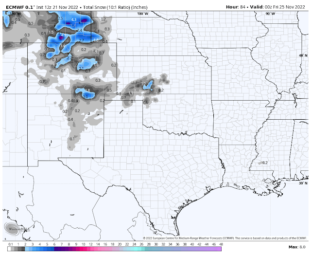
European (ECMWF) Storm Total Snowfall Forecasts.
Thanksgiving Day At Sunset.

Saturday Evening At Sunset.

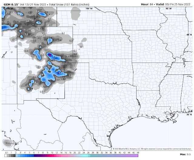
Canadian (GEM) Storm Total Snowfall Forecasts.
Thanksgiving Day At Sunset.


National Blend Of Models (NBM) Storm Total Snowfall Forecasts.
Thanksgiving Day At Sunset.

Saturday Evening At Sunset.

There Are None So Blind As Those Who "Will - Not" To See...107.


Comments
Post a Comment
Your comments, questions, and feedback on this post/web page are welcome.