My Current Weather

Sunday, February 25, 2018

135ºF Temperature Spread In Southeast New Mexico During February.


Sierra Blanca Peak.


Looking Northeast From Alamogordo, NM Saturday, February 24, 2018.

As of February 25th, 2018 Ski Apache has recorded a seasonal snowfall total of 36 inches. They had a base depth of 28 inches this morning. Far below their normal seasonal total 180 inches.

February Temperature Extremes In SE NM.


Topping out with an official high temperature of 100ºF on the 24th after a morning low of 38ºF. That's a temperature rise of 62ºF from the morning low to the afternoon high.

Extreme Cold On February 8th, 1933.


Artesia, New Mexico Records -35ºF.


Hagerman, New Mexico Records -34ºF.


Tatum, New Mexico Records -32ºF.


Pearl, New Mexico Records -30ºF.


As far as I can find in the records books the only other time its has gotten down to -30ºF or colder locally was on the morning of February 3rd, 2011. When the Fort Stanton Raws recorded a low of -31ºF and the Mescalero Raws recorded a low of -30ºF. Unofficially The Inn of The Mountain of Gods Resort dropped down to -30ºF too. 

Carlsbad's high of 100ºF on February 24, 1904 and Artesia's low of -35ºF on February 8, 1933 produces a temperature spread of 135ºF for the month of February! That's remarkable to say the least. 

The Truth Is Stranger Than Fiction!

Tuesday, February 20, 2018

Winter Returns Tonight & Wednesday.


Temperatures At 5 PM MDT Tuesday, Feb 20, 2018.


Forecast High Temperature Anomalies Wednesday.


A strong cold front will push into the local area tonight knocking our daytime high temperatures down into the 30's and 40's on Wednesday. These readings will be some 20 to 30-degrees below normal. Winter is back.

The Truth Is Stranger Than Fiction!

Sunday, February 18, 2018

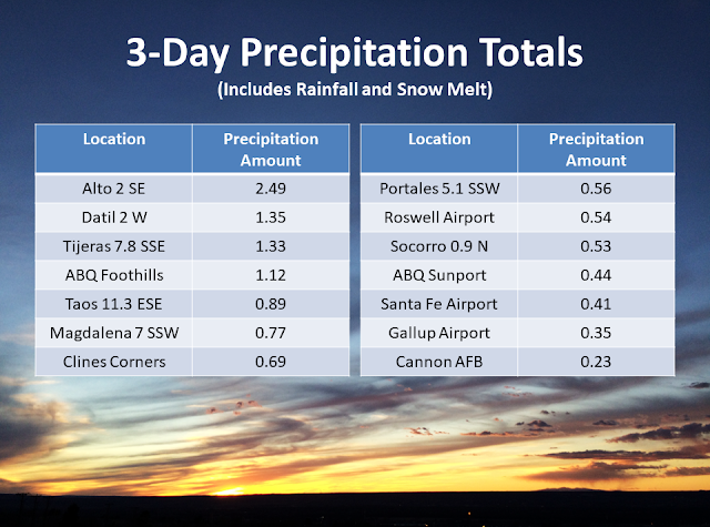
3-Day Storm Total Rainfall & Snowfall Amounts.


Dense Fog South Of The Roswell Airport Saturday Morning.

(As Of 5 AM MST This Sunday Morning).


Most of this precipitation has fallen over the past three days.


Mount Lemon near Tuscon, Arizona ended up with a storm total of 9.17" of rainfall!

NM CoCoRaHS & NM MesoWest Storm Total Rainfall Amounts.

Chaves County.


Eddy County.


Lea County.


Lincoln County.


I'm not sure what is going on with the Sierra Blanca Snotel Gauge. I have a hard time believing that 7.10" of rain fell. Radar storm totals don't support this, and neither do other nearby rainfall totals, and there was no flash flooding on the Ruidoso and Bonitio Watersheds that I am aware of.

Otero County.


Use the 5-day totals for the storm total rainfall amounts over the past four days in the MesoWest column. Most of this precipitation has fallen over the past three days as of 5 AM MST this Sunday morning, February 18, 2018. 

The Truth Is Stranger Than Fiction!

Saturday, February 17, 2018

After The Storm - Dense Fog & Snow Capped Mountains.


Dense Fog Between Artesia & Roswell.
( Saturday Morning, February 17, 2018.)

About Halfway Between Artesia & Roswell.

Fog Bank Ahead South Of Roswell.

Near The Roswell Airport On US Hwy 285.

Looking Back East Towards Roswell Near 12-Mile Hill On US 70.

Capitan Mountains Saturday Morning, February 17, 2018.


Looking North From US Hwy 70 West Of Roswell.

Looking North From St Hwy 380 West Of Lincoln.

Sierra Blanca Peak - Saturday, February 17, 2018.

West Of Lincoln ON St Hwy 380 Near The Fort Stanton Turnoff.


On US Hwy 70 Near Mescalero Looking North.

Whitetail - Mule Deer - Near The Sierra Blanca Regional Airport.


Cloudcroft Ice Skating Rink.

After 2.81" Of Rain & 3.1" Of Snow The Past Two Days.

My wife and I headed north out of Carlsbad early this morning towards Roswell and then west to Ruidoso. Along the way we encountered a dense fog bank about halfway between Artesia and Roswell. The visibility at the Roswell Industrial Air Center was reported to be less than one quarter of a mile at 8 AM MST this morning. This was no joke and we couldn't see more than 50 yards at times. We didn't clear out of the fog bank until we topped out on 12-mile hill west of Roswell on US Hwy 70.

What a beautiful sight the Capitan Mountains and Sierra Blanca Peak (Old Baldy, White Mountain) were this morning. The dense cirrostratus and altostratus clouds made for some varied shades of color on the snow capped peaks and cast different hues and shadows at times.

Not often will you find 2 to 3 inches of rain falling in two days in Cloudcroft (8,750') which in a non La Niña winter normally would have been 20 to 30 inches or so of new snowfall. Not this year much to the disdain of the local Ski Resorts. Ski Apache west of Ruidoso (base elevation of 9,700) picked up 5 inches of new snow and over 3 inches of rain out of this latest storm. This brings their seasonal snowfall total to 28 inches. Normal by now would be around 130 inches or so. They average about 180 inches in a season. Given the current ongoing moderate drought gripping the state the rain was very welcome anyway. 

The Truth Is Stranger Than Fiction!

Friday, February 16, 2018

Arizona Gets 8+ Inches Of Rain In Past 2-Days - Sacramento Mtn's Of NM 2+ Inches.


Storm Clouds Gathering Thursday.

Looking West-Southwest Towards Guadalupe Peak Thursday Afternoon.

Looking Northwest Towards Whites City Thursday Afternoon.


(As Of 5 AM MST Friday Morning).


Month-To-Date Rainfall Totals.
(February 1st - February 16th, 2018 At 5 AM MST).

Most of this has fallen in the past two days!

(Valid As Of 7 AM MST Friday Morning).


(As Of 8 AM MST Friday Morning).

Lincoln County.


Otero County.


(As Of 9 AM MST Friday Morning).

Lincoln County.


Otero County.


Heavy rain have fallen over the Sacramento Mountains since Wednesday. As of 9 AM MST this Friday morning. Totals of this magnitude are defiantly drought busters in some of these locations. some of the heavier storm totals (48-Hour Totals) include the following:

2.3 Miles South Of Cloudcroft 2.09"

1.8 Miles Southwest Of Cloudcroft 1.65"
Smokey Bear Raws In Ruidoso 1.65"
Bonito Lake Northwest Of Ruidoso 1.58"
12.1 Miles Northwest Of Capitan 1.32"
13.4 Miles West-Northwest Of Capitan 1.24"

Radar estimated that around 2.20" of rain may have fallen west of Ruidoso on Sierra Blanca Peak. The remote Snotel Station near Ski Apace reported 4.00" of rain this morning but I have my doubts that this is correct. Too bad this didn't fall in the form of snow. Not to complain however because this rain will go a long ways to knocking down the high fire danger in the Sac's at least for the short term anyway.

(48-Hour Totals As Of Thursday Evening).


Some VERY impressive rain totals across SE AZ in the past 48 hours. Mt. Lemmon and Mt. Graham both over 8 inches. Shown here are both observed totals and radar estimated totals.

Mount Lemon near Tuscon (with 8.62") and Mount Graham (with 8.70") northeast of Tuscon both have had more rain than they normally get any month of the year...in two days. 

More Rain To Come To The Area Today Into Tonight.


Valid At 9:32 AM MST This Friday Morning.


Valid At 5 AM MST This Friday Morning.


Valid At 9:45 AM MST This Friday Morning.

A cold front moved southward into Southeastern New Mexico and West Texas overnight. A colder and more moist air mass at the low levels of the atmosphere now resides over the area.

After seeing our afternoon high temperatures climb up into the low 80's yesterday we will only reach the low 50's today. Some 25 to 30-degrees colder than yesterday.

(Valid Today Through 5 PM MST Sunday).


Regional radar and the latest satellite images continue to show deep sub tropical moisture streaming northeastward from southwest of the Baja Region into New Mexico this morning. A weak upper low located southwest of San Diego was aiding in this process. Additional heavy rains are forecast for the Sacramento Mountains today into tonight. Storm totals in a few locations may exceed 3". Locally our best chances for rain will come this afternoon into tonight. See my forecast page link for additional details. 

The Truth Is Stranger Than Fiction!

NWS Albuquerque Burn Scar Matrix Forecast

Current NWS Watches/Warnings In Effect

New Mexico

Eddy County

Chaves County Plains & Mtn's

Culberson County

Lea County

Lincoln County

Otero County

Current US Temps

Current US Wind Chill/Heat Index Temperatures

NWS Midland Forecast

NWS Albuquerque Forecast

NWS Albuquerque Forecast

NWS El Paso Forecast

NWS Lubbock Forecast

NWS Lubbock Forecast

Average Daily High/Low Temperatures & Rainfall

Average Daily High/Low Temperatures & Rainfall