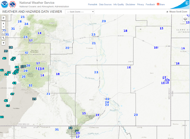
Latest Temperature - Precipitation & Snowfall Summaries.
Snapshot Taken At 10:17 AM MST This Sunday Morning.
An upper level trough of low pressure with a short wave centered over Northeastern New Mexico as of 10 AM MST this morning was weakening and moving northeastward out of the state. Our next upper level storm to possibly affect the state later this week can been seen in this image just southwest of the Oregon Coast.
In yesterday's blog I talked about the shallow modified arctic cold front that had pushed southward into the local area Friday night...backing out to the north and east during the afternoon. Thus allowing our local temperatures west of the Pecos Valley to warm up to near 70ºF. We didn't get this warm in the Pecos Valley because the frontal boundary stalled over the area and kept us in the cooler air.
Roswell (3,622') reported a Saturday afternoon high temp of 50ºF, Artesia (3.514') 52ºF, and Carlsbad (3,294') 53ºF. The Bat Draw Raws (4,425') located at the Carlsbad Caverns Visitor Center southwest of Carlsbad reported 55ºF. So we ended up about 15-degrees colder than what was forecast.
Shallow and weak arctic cold fronts have a hard time working their way westward up and over the Capitan, Sacramento, and Guadalupe Mountains. Yesterday's temperatures proved this. The Roswell Portable Raws #2 located southwest of Roswell and southeast of Picacho manged to climb up to 70ºF. Guadalupe Pass (5,449') southwest of Carlsbad managed to climb up to 69ºF. The Dunken Raws (5,431') reached 67ºF. The Queen Raws (5,605') reached 66ºF. All higher in elevation and further west than the Pecos Valley communities.
Wind Chills Temps Made It Feel Colder.
With our low temperatures this morning in the teens and twenties our wind chill values were even colder. Listed below are a few of the colder readings.
Guadalupe Pass ASOS -6ºF.
Hobbs Airport 4ºF.
Artesia Airport 7ºF.
Carlsbad Airport 11ºF.
December 1st, 2017 - February 10th, 2018.
January 1st, 2018 - February 10th, 2018.
February 1st, 2018 - February 10th, 2018.
Overall temperature-wise we are running close to normal here in Southeastern New Mexico so far this winter. We are a little below average since the beginning of the New Year, normal overall for the winter, and warmer than normal for the first ten days of February.
Meanwhile the western two thirds of New Mexico from the Central Mountains west has consistently been running above to much above normal temperature-wise this winter.
Precipitation Summaries.
(5 AM MST January 1st, 2018 - 5 AM MST January 11th, 2018).
Year-To-Date Departure From Normals.
(5 AM MST December 31st, 2018 - 5 AM MST January 11th, 2018).
(AS Of 5 AM MST This Sunday Morning).
Seasonal Snowfall Totals.
(September 30th, 2017 - February 11th, 2018).
(AS Of 5 AM MST This Sunday Morning).
(October 1st, 2017 - February 11th, 2018).
(Last Updated At 9:30 AM MST This Sunday Morning).
11 ENE RED RIVER - 8.0 in.
• null ANGEL FIRE - 7.5 in.• 5 ESE BLACK LAKE - 7.2 in.
• 3 ESE ANGEL FIRE - 6.0 in.
• 5 ESE RED RIVER - 6.0 in.
• null ROCIADA - 5.0 in.
• 8 SE EAGLE NEST - 4.0 in.
• null RED RIVER - 4.0 in.
• 1 SSE GALLUP - 3.7 in.
• 2 E SAN PABLO - 3.3 in.
• 2 NNE QUESTA - 3.1 in.
• 3 ENE PONDEROSA - 3.0 in.
• 11 NNW CANON PLAZA - 3.0 in.
• 2 E GLORIETA - 3.0 in.
• 8 SSW RED RIVER - 3.0 in.
• 1 SE SAN GERONIMO - 2.8 in.
• 9 ENE SHADY BROOK - 2.5 in.
• 6 SSE SANTA FE - 2.5 in.
• 1 SSE GLORIETA - 2.5 in.
• 4 NNW LAMY - 2.5 in.
• 5 NW LAMY - 2.3 in.
• 8 SSW SAN MIGUEL - 2.0 in.
• 9 E CUBA - 2.0 in.
• null EDGEWOOD - 2.0 in.
• null GRANTS - 2.0 in.
• 6 NNW LAMY - 2.0 in.
• 4 NW SANDIA PARK - 2.0 in.
• 6 WNW TERERRO - 2.0 in.
• 3 NW TRES RITOS - 2.0 in.
• 1 N MORIARTY - 2.0 in.
• null GALLUP - 2.0 in.
• 5 SSW TOADLENA - 2.0 in.
• 3 SSW SANTA FE - 2.0 in.
• 1 ENE SANTA FE - 2.0 in.
• 7 ESE CUBA - 2.0 in.
• 5 NW LAMY - 1.7 in.
• 1 ESE SEDILLO - 1.5 in.
• 2 NW EDGEWOOD - 1.5 in.
• 2 N MILAN - 1.5 in.
• 4 NW LAMY - 1.2 in.
• 2 WSW EDGEWOOD - 1.1 in.
• 7 E CANJILON - 1.0 in.
• 2 SE MANZANO - 1.0 in.
• 8 NE ARROYO SECO - 1.0 in.
• 2 N EDGEWOOD - 1.0 in.
• 2 SW SANTA FE - 1.0 in.
• 3 ENE TUCUMCARI - 1.0 in.
• 1 N MILAN - 1.0 in.
• 3 SSW ENCINO - 0.9 in.
• 2 W SEDILLO - 0.5 in.
• 1 ESE TRUCHAS - 0.5 in.
• 5 ENE LOS CERRILLOS - 0.5 in.
• 15 SSW CLAYTON - 0.5 in.
• 6 W LOS ALAMOS - 0.5 in.
• 7 ESE DES MOINES - 0.3 in.
• null RAMAH - 0.3 in.
• 2 SSW LOS CORDOVAS - 0.3 in.
• 13 NW TAOS - 0.2 in.
• 3 W LOGAN - 0.2 in.
• 20 WNW GRAN QUIVIRA - 0.1 in.
• null PIETOWN - 0.1 in.
• 2 NW EL RITO - 0.1 in.
• 2 E SAN ANTONITO - 0.1 in.
The Truth Is Stranger Than Fiction!


Comments
Post a Comment
Your comments, questions, and feedback on this post/web page are welcome.