My Current Weather

Wednesday, March 30, 2022

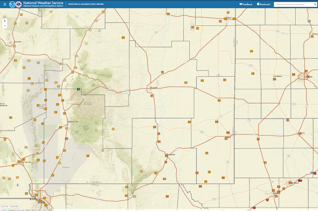
Local Peak Wind Gusts Reported Tuesday, March 29, 2022.

Blog Update At 7:10 AM MDT Thursday, March 31,2022.
Blog Updated At 9:11 AM MDT Saturday, April 2, 2022.


March 31, 2022.
Burn Scar From The March 29th, 2022 Fire.
St Hwy 380 East Of Tatum, NM East To The NM/TX State Line.

My wife and I went to Lubbock, Texas this past Thursday and on our return trip back to Carlsbad I shot these above photos. 


March 30, 2022.
Wind damage from Tuesday night's west wind gust of 59 mph at 11 PM MDT.


Courtesy Of The Lea County Office Of Emergency Management & Environmental.

Yesterday's sustained winds of 36 mph, very low humidity, and extremely dry vegetation led to a very large fire spreading rapidly through Northern Lea County near Tatum and into Texas. Fire size at containment is approximately 17,658 acres and stretched over 14.5 miles with some areas being over two miles wide.
This fire led to residential evacuations, burned vehicles, power outages due to downed powerlines, damaged oilfield equipment, and burned ranch land. We have not recieved any reports of any major injuries and there was no loss of life associated with this fire.
All homes in the path of this fire were protected and all residents are accounted for!
Thank you to all the Emergency Personnel that responded to this fire! Your hard work saved lives, homes, and more cattle than we could count last night!
New Mexico Resources:
Tatum V. Fire Dept
Lea County Sheriff's Office
Lea County Communication Authority
Lea County Office of Emergency Management
Maljamar V. Fire Dept
Lovington Fire Dept
Knowles V. Fire Dept
Hobbs Fire Dept
Lea County Road Dept
Milnesand V. Fire Dept
Dora V. Fire Dept
New Mexico State Police
New Mexico Highway Dept
BLM Fire-Roswell (U.S. Dept of Interior)
New Mexico Forestry Division
East Grand Plains V. Fire Dept
Berrendo V. Fire Dept
Texas Resources:
Denver City V. Fire Dept
Plains V. Fire Dept
Meadow V. Fire Dept
Causey V. Fire Dept
Whiteface V. Fire Dept
Morton V. Fire Dept
Seagraves V. Fire Dept
Yoakum Co. Office of Emergency Management
Yoakum Co. Road Dept
Yoakum Co. Sheriff's Office
Texas A&M Forest Service (Dozers)
Texas Dept of Public Safety
Thank you to all the kind-hearted residents and local businesses that offered assistance in more ways than we can count yesterday!
Thank you to U.S. National Weather Service-Midland for the fire weather monitoring and social media updates to keep our communities informed.
If we missed you on this list, we apologize and appreciate all you did during this fire!

High winds raked the area yesterday afternoon and in some locations continued overnight. Blowing dust developed late yesterday and evening as well. 

A large grass fire broke out east of Tatum Tuesday afternoon and rapidly spread. It has been contained as of this morning after burning a strip two miles wide by fourteen miles long.

A second large grass fire broke out in northeast Roosevelt county between Portales and Clovis near the intersection of U.S. Highway 70 and State Hwy 202 Tuesday afternoon.

Local 24-Hour Reported Peak Wind Gusts:
(Occurred Tuesday, March 29, 2022).

San Augustin Pass - East of Las Cruces 84 mph

Guadalupe Pass 73 mph
Truth or Consequences 71 mph Salinas Peak - White Sands Missile Range 70 mph
Bat Draw Raws - Carlsbad Caverns 68 mph
Pinery Raws - Pine Springs 68 mph
Clovis PWS 65 mph
Bowl Raws - North of Guadalupe Peak 64 mph
Sulf - White Sands Missile Range 63 mph
El Paso International Airport 63 mph
Roswell PWS 2 NW 62 mph
Tatum PWS 62 mph
Delta Clipper - White Sands Missile Range 62 mph
Sierra Blanca Regional Airport Northeast of Ruidoso 62 mph
North Oscura Peak - White Sands Missile Range 60 mph
Apache - White Sands Missile Range 60 mph
El Paso NWS Office Santa Teresa 60 mph
Caprock Raws 59 mph
Carlsbad Airport 59 mph
Cannon AFB Clovis 58 mph
EMRE - White Sands Missile Range 58 mph
White Sands Missile Range Museum 58 mph
Pony - White Sands Missile Range 58 mph
Timberon PWS 57 mph
Dunken Raws 57 mph
Brillo West - White Sands Missile Range 57 mph
Salt Creek - White Sands Missile Range 57 mph Dell City, TX - TTU/WTM 56 mph
Clovis Municipal Airport 56 mph
Eunice PWS West of town 56 mph
Nogal 5 Northwest 56 mph
Carrizozo PWS 56 mph
Apache Point - Cosmic Raws 56 mph
Main Post - White Sands Missile Range 56 mph
Mescalero - Mescal Raws 56 mph

Carlsbad Portable - Southeast of Whites City 54 mph
Artesia Municipal Airport 53 mph
Carlsbad Portable - Southeast of Whites City 54 mph
Sacramento Peak - Sunspot 53 mph
Clines Corners 52 mph
Smokey Bear Raws - 1 Northwest Ruidoso 52 mph
Hill Rolls PWS 52 mph
Carlsbad PWS - Ridgecrest 52 mph
Mayhill PWS - Dimension Point Observatory 51 mph
Holloman AFB Alamogordo 51mph
Las Cruces Airport 49 mph
Elk PWS 48 mph
Hobbs Airport 48 mph
Queen Raws 48 mph
Mayhill Raws 45 mph


Public Information Statement
National Weather Service Albuquerque NM
614 PM MDT Tue Mar 29 2022

...HIGHEST WIND GUST REPORTS...

Location                     Speed     Time/Date

...New Mexico...

...Bernalillo County...
Albuquerque Intl Sunport     44 MPH    0103 PM 03/29

...Catron County...
Old Horse Springs 19 SSE (Pe 43 MPH    1238 PM 03/29

...Chaves County...
Roswell Air Center           64 MPH    0330 PM 03/29
2 NW Roswell                 62 MPH    0210 PM 03/29
Dunken 2 NE (Dunken)         57 MPH    0136 PM 03/29
Bitter Lake WL Refuge 14 NNE 54 MPH    0337 PM 03/29
Roswell No. 1 Portable       48 MPH    0140 PM 03/29

...Cibola County...
I-40 at NM-6 (NMDOT)         49 MPH    1220 PM 03/29

...Colfax County...
Raton Crews Airport          47 MPH    1239 PM 03/29

...Curry County...
Cannon AFB                   58 MPH    0433 PM 03/29
Clovis Muni Airport          56 MPH    0453 PM 03/29
Clovis ASC (NMCC)            45 MPH    0435 PM 03/29
Clovis                       43 MPH    0447 PM 03/29

...De Baca County...
Sumner Lake 1 NW             50 MPH    0347 PM 03/29

...Guadalupe County...
Vaughn 4 E (UPR)             52 MPH    0355 PM 03/29
Santa Rosa Airport           46 MPH    0355 PM 03/29
Milagro 3 ESE                42 MPH    0300 PM 03/29
Santa Rosa 2 SW (UPR)        40 MPH    0417 PM 03/29
Cuervo (UPR)                 40 MPH    0430 PM 03/29

...Harding County...
Mills 4 WSW (Mills Canyon)   42 MPH    1105 AM 03/29

...Lincoln County...
Sierra Blanca Rgnl Arpt      62 MPH    0255 PM 03/29
Shist (WSMR)                 57 MPH    1225 PM 03/29
Nogal 5 NW                   56 MPH    1105 AM 03/29
Pole 616 (WSMR)              54 MPH    0305 PM 03/29
Phillips Hill (WSMR)         54 MPH    0320 PM 03/29
Oscura Range Camp (WSMR)     53 MPH    1225 PM 03/29
Oscuro 4 NE (UPR)            53 MPH    1230 PM 03/29
Ruidoso 1 NNW (Smokey Bear)  52 MPH    0200 PM 03/29
Roswell No. 2 Portable       50 MPH    0220 PM 03/29
Carrizozo 1 WNW              45 MPH    0131 PM 03/29
Ancho 6 SW (UPR)             41 MPH    0126 PM 03/29

...McKinley County...
Gallup Airport               41 MPH    0333 AM 03/29

...Quay County...
Tucumcari Muni Airport       59 MPH    0211 PM 03/29
Tucumcari 9 NE  (UPR)        54 MPH    0511 PM 03/29
Endee 2 SW                   52 MPH    0354 PM 03/29

...Roosevelt County...
2 WSW Dora                   58 MPH    0315 PM 03/29
Tolar 13 SE (Melrose Range)  50 MPH    0414 PM 03/29
Portales 1 SW                48 MPH    0245 PM 03/29

...San Miguel County...
Las Vegas Muni Airport       49 MPH    0809 AM 03/29
Bell Ranch 11 ENE            45 MPH    1255 PM 03/29

...Santa Fe County...
Santa Fe Muni Airport        40 MPH    0150 PM 03/29

...Socorro County...
10 SSE Magdalena             65 MPH    0121 PM 03/29
Sulf (WSMR)                  63 MPH    1115 AM 03/29
North Oscura Peak (WSMR)     60 MPH    1220 PM 03/29
Stallion WIT (WSMR)          56 MPH    1140 AM 03/29
Zumwalt Track (WSMR)         54 MPH    1205 PM 03/29
Carrizozo 15 NW (Chupadera)  52 MPH    0139 PM 03/29
Harry (WSMR)                 50 MPH    0220 PM 03/29
Stallion Runway (WSMR)       49 MPH    0155 PM 03/29
Mine (WSMR)                  49 MPH    0315 PM 03/29
Socorro Airport              45 MPH    0135 PM 03/29
Contreras 1 ESE (Sevilleta)  43 MPH    0211 PM 03/29
Magdalena 3 ENE              41 MPH    1144 AM 03/29
Las Nutrias 1 WNW            40 MPH    0200 PM 03/29

...Torrance County...
Clines Corners 1 SSE         53 MPH    1222 PM 03/29
Estancia 2 WSW               47 MPH    1028 AM 03/29
Corona 1 NE (UPR)            47 MPH    1256 PM 03/29
Duran 7 SW (UPR)             43 MPH    1157 AM 03/29
Moriarty Muni Airport        43 MPH    1255 PM 03/29
Estancia 7 SSW               43 MPH    0145 PM 03/29
1 W Mountainair (Mountainair 41 MPH    0405 PM 03/29

...Union County...
Clayton Muni Airpark         58 MPH    1200 PM 03/29
Clayton LRC                  51 MPH    0140 PM 03/29

...Valencia County...
Belen Regional Airport       45 MPH    1255 PM 03/29

Observations are collected from a variety of sources with varying
equipment and exposures. We thank all volunteer weather observers
for their dedication. Not all data listed are considered official.

$$
NWS El Paso/Santa Teresa Reported 24-Hour Peak Wind Gusts.
Public Information Statement
National Weather Service El Paso TX/Santa Teresa NM
1122 PM MDT Tue Mar 29 2022

...HIGHEST WIND REPORTS...

Location                     Speed     Time/Date       Lat/Lon
San Agustin Pass 1.6 E Organ 84 MPH    0320 PM 03/29   32.43N/106.57W
T-or-C ASOS                  71 MPH    0150 PM 03/29   33.23N/107.27W
Salinas Peak (WSMR)          64 MPH    0425 PM 03/29   33.30N/106.53W
El Paso International Airpor 63 MPH    0116 PM 03/29   31.82N/106.38W
Delta Clipper                62 MPH    0200 PM 03/29   32.90N/106.41W
WSMR Apache                  60 MPH    1240 PM 03/29   32.63N/106.39W
Sierra Blanca (TTU/WTM)      59 MPH    0656 PM 03/29   31.16N/105.35W
WSMR Building 1830           59 MPH    1030 PM 03/29   32.37N/106.47W
WSMR Pony                    58 MPH    1240 PM 03/29   32.87N/106.49W
Chihuahuan Desert Rangeland  58 MPH    0105 PM 03/29   32.53N/106.81W
WSMR EMRE                    58 MPH    1025 PM 03/29   32.47N/106.50W
WSMR Museum                  58 MPH    1040 PM 03/29   32.38N/106.48W
WSMR LC-32                   57 MPH    0730 AM 03/29   32.41N/106.40W
WSMR Salt Creek              57 MPH    1250 PM 03/29   33.12N/106.36W
WSMR Jallen Hawk 40          57 MPH    0115 PM 03/29   33.17N/106.49W
Brillo West                  57 MPH    0135 PM 03/29   32.96N/106.54W
Mescalero RAWS               56 MPH    0241 PM 03/29   33.16N/105.77W
WSMR Tula Airstrip           56 MPH    0335 PM 03/29   33.06N/106.15W
San Andres RAWS              56 MPH    0401 PM 03/29   32.58N/106.53W
Dell City (TTU/WTM)          56 MPH    0600 PM 03/29   31.95N/105.20W
Globe                        56 MPH    1030 PM 03/29   32.38N/106.47W
WSMR Main Post               56 MPH    1040 PM 03/29   32.37N/106.49W
Condron Field (WSMR)         55 MPH    1255 PM 03/29   32.34N/106.41W
Dripping Springs RAWS        55 MPH    0426 PM 03/29   32.32N/106.59W
Deming ASOS                  54 MPH    1212 PM 03/29   32.27N/107.72W
WSMR Denver WIT              54 MPH    0100 PM 03/29   33.24N/106.36W
Biggs Field AWOS             54 MPH    0124 PM 03/29   31.85N/106.38W
Globe                        54 MPH    0905 PM 03/29   32.38N/106.47W
WSMR Alt Shist               53 MPH    1220 PM 03/29   33.44N/106.41W
WSMR Main Post               53 MPH    1225 PM 03/29   32.37N/106.49W
WSMR ABC-1                   53 MPH    0150 PM 03/29   33.16N/106.33W
Santa Teresa AWOS            53 MPH    0415 PM 03/29   31.88N/106.70W
WSMR Building 1830           53 MPH    0755 PM 03/29   32.37N/106.47W
WSMR EMRE                    52 MPH    1245 PM 03/29   32.47N/106.50W
WSMR Tula                    52 MPH    0125 PM 03/29   33.07N/106.18W
High Rolls                   52 MPH    0137 PM 03/29   32.94N/105.84W
Malone                       52 MPH    0235 PM 03/29   32.90N/106.10W
WSMR Museum                  52 MPH    0335 PM 03/29   32.38N/106.48W
McGregor Range RAWS          52 MPH    0337 PM 03/29   32.43N/105.62W
Mayhill - Dimension Point Ob 51 MPH    1100 AM 03/29   32.91N/105.53W
Holloman AFB AWOS            51 MPH    0108 PM 03/29   32.85N/106.08W
Las Cruces                   49 MPH    0100 PM 03/29   32.36N/106.72W
Russ                         49 MPH    0135 PM 03/29   33.32N/106.12W
Alamogordo SE                49 MPH    0317 PM 03/29   32.89N/105.94W
Las Cruces AWOS              49 MPH    0355 PM 03/29   32.27N/106.92W
WSMR C-Station               49 MPH    0430 PM 03/29   32.36N/106.38W
Lordsburg Playa I10 MP13 (NM 48 MPH    0255 PM 03/29   32.32N/108.81W
Santa Teresa NWS RSOIS       48 MPH    0404 PM 03/29   31.87N/106.70W
WSMR Rita                    47 MPH    0115 PM 03/29   33.18N/106.15W
Alamogordo AWOS              47 MPH    0115 PM 03/29   32.82N/105.97W
WSMR Frequency               47 MPH    0245 PM 03/29   32.82N/106.15W
Lordsburg Playa I10 MP11 (NM 47 MPH    0300 PM 03/29   32.28N/108.88W
Lc-35 North                  47 MPH    0515 PM 03/29   32.44N/106.34W
Spaceport America Awos       46 MPH    1230 PM 03/29   32.99N/106.97W
Las Cruces                   46 MPH    1238 PM 03/29   32.39N/106.72W
Las Cruces - S Fork LC Arroy 46 MPH    0115 PM 03/29   32.34N/106.71W
Mayhill RAWS                 45 MPH    1201 PM 03/29   32.91N/105.47W
Winston (EPZWxNet)           45 MPH    0128 PM 03/29   33.35N/107.65W
Lordsburg Playa I10 MP9 (NMD 45 MPH    0255 PM 03/29   32.27N/108.90W
Lordsburg Playa I10 MP12 (NM 45 MPH    0305 PM 03/29   32.29N/108.87W
WSMR Cad                     45 MPH    0340 PM 03/29   32.37N/106.34W
Burro Mountain RAWS          44 MPH    1259 AM 03/29   32.67N/108.54W
El Paso NE - K5IA            44 MPH    0100 PM 03/29   31.91N/106.41W
WSMR Rob                     44 MPH    0240 PM 03/29   33.39N/106.66W
PX Well RAWS                 44 MPH    0553 PM 03/29   31.97N/104.95W
Chiricahua Desert Museum     43 MPH    0220 AM 03/29   31.87N/109.02W
Las Cruces - High Ridge (DAC 43 MPH    1217 PM 03/29   32.38N/106.74W
Las Cruces - Tierra Grande ( 43 MPH    0100 PM 03/29   32.39N/106.67W
Organ (DACFC)                43 MPH    0258 PM 03/29   32.42N/106.60W
Butterfield Trail Ranch      43 MPH    0344 PM 03/29   32.26N/107.24W
Las Cruces - N Fork LC Arroy 42 MPH    1243 PM 03/29   32.35N/106.70W
Dona Ana County Fairgrounds  42 MPH    0406 PM 03/29   32.26N/106.97W
Hachita Valley               40 MPH    0540 AM 03/29   31.70N/108.34W
Las Cruces - East Mesa       40 MPH    1237 PM 03/29   32.40N/106.68W
Lordsburg Playa I10 MP7 (NMD 40 MPH    0255 PM 03/29   32.25N/108.93W
The Truth Is Stranger Than Fiction!

Monday, March 28, 2022

Significant High Wind/Blowing Dust Event Possible Tuesday!


First 90-Degree Temps Sunday.

Sunday afternoon saw the local area's first 90-degree high temps for the year. Reported high temperatures ranged from 92 at the Roswell and Carlsbad Airports, 90 at the Artesia and Hobbs Airports, to 75 at the Sierra Blanca Regional Airport northeast of Ruidoso, and 60 at the Cloudcroft National Weather Service Climate Co-Op Station. My afternoon high temp here at our home in Carlsbad was 94. This afternoon high temperatures are forecast to be close to Sunday's readings.


Valid At 6 AM MDT Tuesday.


At Midnight Sunday Night.

ECMWF 500 MB (18,000' MSL) Forecast.

Valid At 6 PM MDT Tuesday.

Late last night our next strong Spring Storm was centered west of San Francisco and is forecast to dive southeastward rather quickly today into tomorrow. This inbound storm will produce a variety of weather across the area including high winds, blowing dust, rain, and snow showers, and Critically Dangerous to Extremely Critically Dangerous Fire Weather Conditions. This storm will be sweeping across the area faster than last week's storm so it will produce less rain and snow.

Critically Dangerous Fire Weather Conditions Today - Extremely Critically Dangerous Fire Weather Conditions Tuesday!


Storm Prediction Center Outlook Tuesday.


With strong/high winds slated to rake the area this afternoon into Wednesday the fire danger is going through the roof. Critically Dangerous Fire Weather Conditions are forecast today and this escalates to Extremely Critically Dangerous Fire Weather Conditions Tuesday! Single-digit relative humidity values, combined with the prevailing critical to extreme drought conditions will combine with the strong/high winds to produce life-threatening fire weather conditions today and especially Tuesday.

Any wildland, grass, range, or forest fires that may develop will have the ability to rapidly spread and grow today but more so Tuesday into Tuesday evening. These fires will be extremely difficult if not impossible to control in the high winds. Life and property could potentially be threatened by these fast-moving raging fires. Sadly we have already seen this happen in parts of Texas and other nearby areas this season.

Smoke from these fires could combine with thick clouds of blowing dust, especially on Tuesday to suddenly reduce the visibility to zero with little to no warning. Simply put please avoid all outdoor activities today and Tuesday that could potentially produce sparks or flames.


Strong Winds This Afternoon - A Significant High Wind & Blowing Dust Event Tuesday!

With the approaching mid-upper level storm and its associated Pacific cold front swinging across New Mexico on Tuesday, and the rapidly deepening surface low over southeastern Colorado and Kansas, a significant high wind and blowing dust event is forecast area-wide.

Strong southwesterly winds sustained at around 15-25 mph with stronger gusts this afternoon are forecast across the lower elevations of the Southeastern Plains and nearby areas. These winds will increase to sustained speeds of 30-50 mph with gusts near 60-70 mph Tuesday into Tuesday evening. Shifting to the west and northwest Tuesday evening and night. 

West winds are forecast to gust up to around 35-45 mph today into tonight across the Guadalupe Mountains of Southeastern New Mexico and West Texas. These winds are forecast to increase to sustained speeds of 45-55 mph with gusts near 80 mph on Tuesday.

High Wind Watches are in effect for all of Southeastern New Mexico, the Sacramento, and Guadalupe Mountains. These will likely be upgraded to High Wind Warnings later today or early Tuesday. Additional High Wind Watches and or Wind Advisories may also be issued for other local areas not currently covered.

It's possible that a few locations could see higher gusts. There is also the potential for wind damage Tuesday with the stronger gusts. This will be especially true if those gusts reach or exceed 60 mph. Tree limbs could be broken, power lines and other utility cables downed, roofs on sheds, barns, and homes could be damaged. Agriculture irrigation equipment (sprinkler systems) could also be damaged or blown away. Outdoor unsecured objects could be blown about or damaged also such as trach barrels, trampolines, and carports.   

Widespread blowing dust will develop and overspread the area on Tuesday greatly reducing the visibility and obscuring the sky. Localized sudden drops in the visibility down to zero with little to no advanced warning will occur with the strongest gusts. Especially over and near freshly cultivated or plowed farmlands, open or exposed fields and lots, and highway and other construction sites. 

It's possible that some local roadways and highways could temporarily be shut down or closed during the worst of the wind gusts and blowing dust. Remember that the area has a history of vehicle accidents with injuries and fatalities during these blinding dust storms.


Today.


Tuesday.


Wednesday.


Day 2 Severe Weather Outlook.


As the Pacific cold front races east and overtakes the dryline Tuesday night a few severe thunderstorms may develop of parts of the far eastern Permian Basin of West Texas. Severe thunderstorms are forecast to be more numerous and widespread further east and north into central and northern Texas, Oklahoma, and Kansas. 


Valid Today Through 6 AM MDT Thursday.

Valid Today Through 6 AM MDT Thursday.


Scattered rain and high mountain snow showers are forecast to break out over the Sacramento and Capitan Mountains late tonight or early Tuesday morning. A few thunderstorms will also be possible with thundersnow in the forecast. Snow levels are forecast to lower down to around 7,000' Tuesday afternoon and evening. Current forecasts are calling for 1" - 4" inches of accumulating snow above 7,000'.

A few scattered light rain showers will be possible over parts of Southeastern New Mexico Wednesday into Wednesday night. But overall most of us will remain rain-free except for ample amounts of New Mexico rain...blowing dust. 

The Truth Is Stranger Than Fiction!

Thursday, March 24, 2022

Hot This Weekend - Next Storm Mid-Week.

Valid At Noon MDT Wednesday, March 30, 2022.


Valid At 6 PM MDT Tuesday, March 29, 2022.

Hot This Weekend - Next Storm Mid-Week.

Spring is notorious for being turbulent weather-wise and this spring has certainly started on that turbulent note. It's the time of the year when cold air masses and warm air masses collided from time to time. When this happens a variety of weather occurs. Such will be the case from the first to the middle of next week. 

A warmup is now occurring behind our latest storm that has departed. Seasonally hot temperatures will occur across the local area Sunday and Monday ahead of yet another winter-like storm. That strong spring storm will affect the area Tuesday into Thursday of next week with a variety of weather including strong winds, blowing dust, high fire danger, areas of rain and snow along with colder temps.

Forecast high temps for Southeastern New Mexico and nearby areas will climb up to near 90 to the low 90's Sunday and Monday. A few local record high temps may be threatened. 

Like our last storm, this next strong spring storm will likely drop its highest amounts of rain and snow over and near the mountains. 


Today.


Friday.


Saturday.


Sunday.


Monday.


Valid At 6 PM MDT Wednesday, March 30, 2022.

GFS Snowfall Forecast.

Valid At 6 PM MDT Wednesday, March 30, 2022.

First and foremost it's really too early to get to specific with impacts from next week's storm. It does have a similar look to our storm from a couple of days ago at least in the GFS models forecasts. So take all of this with a grain of salt and know that although the exact details can't be resolved yet, there will be another strong spring storm next week impacting the region.

Given the time of the year, the mountains of New Mexico will likely see the highest snowfall. But that does not mean that some lower elevations won't get snow. Severe thunderstorms may once again plaque Texas, Oklahoma, Louisiana, and the rest of the central and southern parts of the nation next week. More on all of this later.

The Truth Is Stranger Than Fiction!

Wednesday, March 23, 2022

Storm Summary March 21-23, 2022.

March 21, 2022.
Looking West At The Guadalupe Mtn's.
High Based - Low Topped Rain/Snow Showers Over Texas Hill.

(March 21-23, 2022).


NM CoCoRaHS 72-Hour Snowfall Totals.


Consider joining CoCoRaHS today and becoming a volunteer rainfall, snowfall, and hail observer by signing up via this link


This latest spring storm to affect New Mexico produced some very respectful rainfall and snowfall totals. Some of the heavier storm totals include but are not limited to the following:

Sunspot CoCoRaHS Station 0.2 SSW 1.47" With 13.4" Of Snowfall.
Cloudcroft NWS Climate Co-Op Station 1.36" And 14.3" Of Snowfall.
Cloudcroft CoCoRaHS Station 2.3 Miles S 1.36" And 14.3" Of Snowfall.
Bowl Raws North Of Guadalupe Peak 1.13"
Pine Springs - Guadalupe Mtn's Natl Park 1.11"
Mountain Park NWS Climate Co-Op Station .85"
Personal Weather Station (PWS) South Alamogordo .83"
Sierra Blanca Snotel Near Ski Apache .80"
Mescal Raws - Mescalero Raws .66"
Queen Raws .44"
Bat Draw - Carlsbad Caverns .31"

While once again the Southeastern Plains were left pretty much high and dry:

Hope NWS Climate Co-Op Station .14"
Roswell Airport ASOS .11"
Carlsbad Airport ASOS .10"
Our Home In NW Carlsbad .03"
Personal Weather Station (PWS) Hobbs .02"
Personal Weather Station (PWS) Tatum .02"

The Truth Is Stranger Than Fiction!

NWS Albuquerque Burn Scar Matrix Forecast

Current NWS Watches/Warnings In Effect

New Mexico

Eddy County

Chaves County Plains & Mtn's

Culberson County

Lea County

Lincoln County

Otero County

Current US Temps

Current US Wind Chill/Heat Index Temperatures

NWS Midland Forecast

NWS Albuquerque Forecast

NWS Albuquerque Forecast

NWS El Paso Forecast

NWS Lubbock Forecast

NWS Lubbock Forecast

Average Daily High/Low Temperatures & Rainfall

Average Daily High/Low Temperatures & Rainfall