A Mixed Bag Of Winter & Spring Weather Today Into Tuesday.
Carlsbad, New Mexico.
A strong cold front passed southward through the Southeastern Plains of New Mexico last Thursday afternoon. Winds shifted around to the north with the frontal passage. A peak gust to 56 mph was clocked at the Carlsbad Airport and 55 mph at Carlsbad Caverns. Blowing dust briefly reduced the visibility down to less than a mile in Carlsbad.
Spring storms are often very strong and dynamic and this will be the case with the one now approaching the region. Late last night a mid-upper short wave trough of low pressure was located over central California and was in the process of closing off. This can clearly be seen in this morning's water vapor image snapshot above. This closed low will deepen as it slides southeastward. By Monday morning it is forecast to be centered near El Paso.
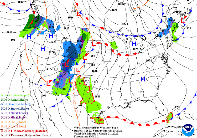
Valid At Midnight MDT Sunday Night.
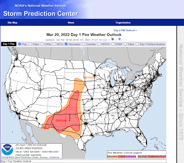
Strong Winds/Blowing Dust/Critically Dangerous Fire Weather Conditions Today.
Strong southerly to southwesterly winds will develop areawide today which will aid in producing Critically Dangerous Fire Weather Conditions.
Red Flag Warnings are in effect today for the entire area and Fire Weather Watches are in effect for Monday. Please refrain from any type of outdoor activity that involves the use of sparks or flame today and Monday. Any wildfire, grass fire, range fire, or forest fire that develops will have the potential to rapidly spread and grow in the high winds and very dry conditions.
Red Flag Warnings are in effect today for the entire area and Fire Weather Watches are in effect for Monday. Please refrain from any type of outdoor activity that involves the use of sparks or flame today and Monday. Any wildfire, grass fire, range fire, or forest fire that develops will have the potential to rapidly spread and grow in the high winds and very dry conditions.
A High Wind Watch is in effect on Monday for the Guadalupe Mountains of Eddy County and West Texas. West winds sustained at around 35-50 mph with gusts near 70 mph are forecast.
Additional High Wind Watches and Wind Advisories could possibly be issued for the state and local area for Monday so please check your local forecasts for these.
Additional High Wind Watches and Wind Advisories could possibly be issued for the state and local area for Monday so please check your local forecasts for these.
Southerly winds sustained at around 25-35 mph with gusts near 50 mph are expected locally this afternoon and evening. These winds will shift around to the southwest and west on Monday. And then northerly Monday night with the back door frontal passage.
Localized areas of blowing dust are expected areawide this afternoon and again on Monday. Any thunderstorm that develops may aggravate these conditions with stronger wind gusts especially if they are dry in nature and produce virga bombs.
Sudden drops in the visibility down to less than a mile will occur with the stronger wind gusts and thunderstorms. Especially over our normal dust-prone areas such as freshly plowed or exposed farmland, fields, lots, and highway construction sites. Areas of widespread blowing dust originating from northern Mexico are possible this afternoon and evening especially over southern New Mexico and Far West Texas.
(Sunday Into Sunrise Wednesday Morning).
As the strong storm aloft deepens and approaches the state from the west a dryline will develop over the eastern third of New Mexico this afternoon. Low-level Gulf of Mexico moisture will increase somewhat east of the dryline late this afternoon and evening across Southeastern New Mexico and nearby West Texas.
Isolated thunderstorms will be possible along and east of the dryline late this afternoon and evening. Our chances for seeing measurable rainfall from these storms are only in the 10% to 20% category. Current forecasts do not call for severe thunderstorms locally. However, with such cold temperatures aloft associated with the inbound storm don't be surprised if a few thunderstorms produce small hail.
An eastward moving Pacific cold front is forecast to sweep into Southeastern New Mexico around sunrise Monday morning and overtake the dryline. A southward moving backdoor cold front is forecast to move through the area by late Monday afternoon.
Rain chances will increase Monday areawide as low-level moisture increases along with instability and lift associated with the cold pool of the approaching mid-upper level low. Across the local area, our chances of seeing measurable rainfall jumps up into the 50% to 60% category on Monday. Widely scattered thunderstorms will also dot the landscape.
Storm total rainfall amounts for the Southeastern Plains are currently forecast to generally range from a tenth of an inch to three-tenths of an inch. Isolated higher totals are possible especially associated with any thunderstorm that occurs.
Storm total rainfall amounts for the Southeastern Plains are currently forecast to generally range from a tenth of an inch to three-tenths of an inch. Isolated higher totals are possible especially associated with any thunderstorm that occurs.
Mountain & Plains Snowfall.
(Sunday Into Sunrise Wednesday Morning).
Snow levels across the Sacramento and Capitan Mountains will start out around 8,000' this evening lowering down to around 6,000' early Monday morning. The best chances for snowfall will occur Monday into Monday night. Scattered snow showers are forecast off and on through Wednesday.
Storm total snowfall amounts are currently forecast to be around 1"- 4" across the higher elevations of the Sacramento and Capitan Mountains tonight through Wednesday morning. This includes areas generally above 6,000'. Should the storm to our west shift further south then these totals could be higher. If it lifts further to the north then they will be less.
Depending upon how far south the mid-upper level low tracks on Monday will determine how much snowfall falls across northeastern and eastern New Mexico Monday night into Tuesday. Current forecasts call for a cold rain to change over to snow in the Clovis and Portales areas Monday night with near blizzard conditions possible into Tuesday morning. Snowfall totals of 1" - 2" are currently forecast. Corna is expecting 2"-3" as is the Ruidoso area. 3"-4" are possible in Cloudcroft and nearby higher elevations.
Blizzard conditions will occur over northeastern New Mexico Monday night into Tuesday morning accompanied by northerly wind gusts of around 50 mph.
With low temperatures approaching freezing Monday night light snow showers will be possible across parts of Southeastern New Mexico. Right now the thinking is that this will occur roughly north of a Picacho-Roswell-Tatum-Lubbock line. This could change and shift either north or south depending upon what happens with the mid-upper level storms track and speed Monday into Tuesday.
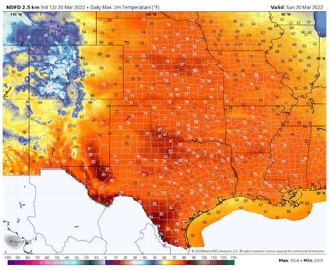
Today.
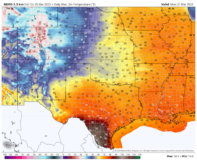
Monday.
Tuesday.
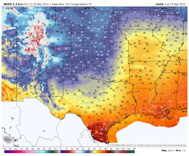
Cooler temperatures are forecast areawide beginning Monday and continuing into mid-week behind the two cold fronts that are forecast to move through. Highs across the Southeastern Plains today are expected to be in the low-mid 80's. Cooling to the low-mid 60's on Monday and the upper 50's to near 60 on Tuesday.
For the Timberon, Mayhill, Sacramento/Weed, High Rolls/Mountain Park, Ruidoso, Capitan, Hondo, and Alto areas you will see high temps today in the low-mid 60's. These will cool down to the mid-upper 40's Monday into Wednesday.
For the Cloudcroft, Sunspot, and Ski Apache areas you will see high temps today in the mid 40's to the mid 50's. Cooling down into the low 30's Monday into Wednesday.
Please stay weather alert and be prepared for the possibility of changes to our local weather forecasts. Local city/town/community forecasts are available on my main weather web page. As always I appreciate you stopping by and reading my blogs. Stay safe everyone.
The Truth Is Stranger Than Fiction!








Comments
Post a Comment
Your comments, questions, and feedback on this post/web page are welcome.