My Current Weather

Monday, March 31, 2014

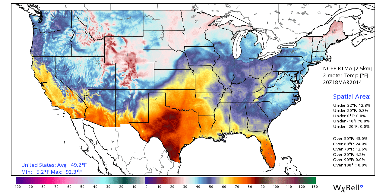
Temp Battle Across The Plains.


Time to play "Lets Find The Cold Front." These are temperatures at 3 pm MDT this afternoon. Temps range from the teens across N/S Dakota to the 90's in TX. Summer wants control but winter refuses to give up.

The Truth Is Stranger Than Fiction! 

 My Web Page Is Best Viewed With Google Chrome.

Wednesday, March 26, 2014

Last Nights Rainfall Totals.


Blog Updated @ 3:25 PM MDT.

Doppler Radar Estimated 24-Hour Rainfall Totals.

Midland NWS Doppler Radar.

Cannon AFB Doppler Radar.

WeatherLink Rainfall Totals.


The Truth Is Stranger Than Fiction! 

 My Web Page Is Best Viewed With Google Chrome.

Tuesday, March 25, 2014

Are You Ready For Some Rain & Perhaps Some Thunderstorms?


Valid @ 6 AM MDT Wednesday.

Valid @ 6 AM MDT Wednesday.

Valid @ 6 AM MDT Wednesday.

Valid @ 6 AM MDT Wednesday.

Valid @ 6 AM MDT Wednesday.

Valid @ 6 PM MDT This Evening.

Valid @ 10 PM MDT Tonight.

Well blow me down Martha because we have...wait for it, wait for it, here it comes, rain in our forecast for tonight! No your eyes are not playing tricks on you its real.

 A weak upper-level low located over northern Baja early this morning will shift east today into tomorrow. Low-level moisture has increased over the area behind a cold front that moved through last night. As the upper low approaches the atmosphere will become unstable, especially tonight, and scattered rain showers and a few thunderstorms will break out.

Some of us could get lucky enough to pick up .25" to .50" of rain by tomorrow morning. There may even be a few spots that could possibly see higher totals than this. A few of the stronger thunderstorms may even produce some small hail and gusty winds. We are all sick and tired of the blowing dust so the rains will be a welcome relief although they won't end the ongoing drought. 

Our best shot at getting wet will come tonight with most of southeastern New Mexico having about a 40% to 60% chance of seeing measurable rainfall. Today will be a little cooler with highs in the 60's to near 70.

The Truth Is Stranger Than Fiction! 

 My Web Page Is Best Viewed With Google Chrome.

Tuesday, March 18, 2014

Southward Moving Cold Front & Haboob Headed To SE NM This Evening.


Blog Updated @ 5:15 PM MDT.


Blowing Dust Over Eastern NM.
(Haboob Moving South With The Cold Front).

MODIS View Of Dust In West Texas And Southeast Colorado.

MODIS (Aqua) Visible Satellite Image This Afternoon.
Blowing Dust Across West Texas. A Haboob In Northeastern
New Mexico & The Northern Texas Panhandle Moving Southward.


Courtesy Of The Lubbock NWS Office.

Latest visible satellite image shows the wall of blowing dust (haboob) moving southward, along with the southward moving cold front. Across northeastern New Mexico and the Texas Panhandle at 4:39 PM MDT this afternoon.

Temperatures across southeastern New Mexico and west Texas are mostly in the 70's as of 3 PM MDT this afternoon. Westerly to northwesterly winds are gusting up to between 30 - 50 mph. 

Two areas of blowing dust are affecting parts of the area this afternoon. A large area of blowing dust stretches across eastern New Mexico from west of the Clovis and Portales area, eastward to east of the Lubbock, Texas area. Visibilities down to 1/4 of a mile have been reported in these areas due to the blowing dust.

Another large area of blowing dust was located across southeastern Colorado, northeastern New Mexico, and the northern Texas Panhandle. This area of blowing dust is associated with a southward moving cold front and its associated haboob. Visibilities of less than 1/4 of a mile have also been reported in these areas associated with the blowing dust.

This cold front will continue moving southward and will arrive in southeastern New Mexico later this evening. We too may experience limited visibilities in blowing dust perhaps less than 1/2 of a mile when the cold front and haboob arrives, and for a time after the frontal passage

Wednesday will see cooler temps behind the front with our afternoon highs only in the 50's & 60's.

The Truth Is Stranger Than Fiction!

 My Web Page Is Best Viewed With Google Chrome.

Sunday, March 16, 2014

Some Of Us Got Wet Last Night.


(As Of 7 AM MDT This Morning).


The Truth Is Stranger Than Fiction!

 My Web Page Is Best Viewed With Google Chrome.

Saturday, March 15, 2014

Another Haboob Tonight - Maybe Some Light Preicp Too.


Last Nights 06Z/Midnight MDT GFS 500 MB Forecast.
Valid @ Midnight Tonight.

Last Nights 06Z/Midnight MDT GFS Precipitation Type Forecast.
Valid @ Midnight Tonight.

Last Nights 06Z/Midnight MDT GFS Precipitation Type Forecast.
Valid @ 6 AM MDT Sunday.

Last Nights 06Z/Midnight MDT GFS Total Precipitation Forecast.
Valid @ 6 PM MDT Sunday.


We should be grateful that March so far has been rather tame considering its usually a fairly nasty month weather-wise. An upper-level disturbance will drop southward into southern New Mexico by tonight. This disturbance will be accompanied by a cold front. 

Red Flag Warnings are in effect today for the local area...so please avoid any outdoor activity that involves the use of sparks or flame. It won't take much for an accidental fire to quickly get out of hand and rapidly grow and spread in today's gusty winds combined with the very dry conditions.

Today will be warm and windy ahead of the approaching upper level storm and cold front. Most of southeastern New Mexico will see afternoon highs in the 70's. As the front plows southward through the area tonight, strong gusty northwesterly to northerly winds will accompany it, which will gust up to around 50 mph. Therefore a Wind Advisory has been issued. 

Blowing dust will also occur along with the possibility of another Haboob. Some locations may see the visibility drop down to less than one mile.

We also may see a mix of light rain and snow late tonight into early tomorrow morning. Although I wouldn't get too excited about any accumulations or significant rainfall totals. Highs on Sunday will only be in the 50's.

The Truth Is Stranger Than Fiction! 

 My Web Page Is Best Viewed With Google Chrome.

Tuesday, March 11, 2014

Northerly Winds Gusting Up To 50 MPH & Blowing Dust Tonight.


My high temp here at our home in Carlsbad this afternoon so far has been a balmy 86F. By this time tomorrow we should be about 30-degrees colder. Most of us will see highs only in the 50's.

A strong southward moving cold front will arrive in southeastern New Mexico later tonight. Gusty northerly winds and falling temps along with blowing dust can be expected as the front arrives. Clayton in northeastern New Mexico had a visibility of only 13/4 of a mile in blowing dust at 4 PM MDT. Northerly winds sustained at around 25 - 35 mph with gusts near 50 mph are forecast mainly after 8 PM MDT for Eddy County.

The Truth Is Stranger Than Fiction! 

 My Web Page Is Best Viewed With Google Chrome.

NWS Albuquerque Burn Scar Matrix Forecast

Current NWS Watches/Warnings In Effect

New Mexico

Eddy County

Chaves County Plains & Mtn's

Culberson County

Lea County

Lincoln County

Otero County

Current US Temps

Current US Wind Chill/Heat Index Temperatures

NWS Midland Forecast

NWS Albuquerque Forecast

NWS Albuquerque Forecast

NWS El Paso Forecast

NWS Lubbock Forecast

NWS Lubbock Forecast

Average Daily High/Low Temperatures & Rainfall

Average Daily High/Low Temperatures & Rainfall