My Current Weather

Saturday, May 30, 2015

Tornado South Of Dora In Roosevelt County - 5-29-2015.


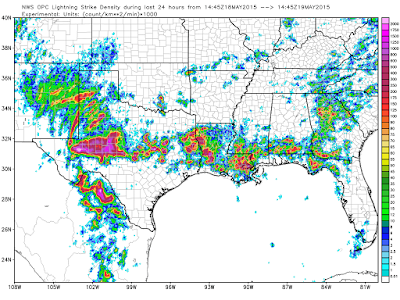
A line of Severe Thunderstorms formed over northeastern and eastern New Mexico late yesterday afternoon and marched southeastward. I shot this Tail End Charlie storm some 50 miles to my north as it was approaching Lovington, NM in Lea County. I was on Hwy 128 in Lea and Eddy Counties looking north. It had a nice overshooting top and was Severe Warned at the time.

Locally Heavy Rain & Severe Weather.

24-Hour Estimated Rainfall.
Via The Cannon AFB (KFDX) Dual Pol Doppler Radar.

24-Hour Estimated Rainfall.
Via The Midland NWS (KMAF) Dual Pol Doppler Radar.


Additional Rainfall Reports Can Be Found Here:


Storm Chaser Christian Cleary (MonsoonMadness.Net) shot this video of a tornado 25 miles south of Dora, New Mexico in Roosevelt County. You can see photos of the tornado on his FaceBook Page and on his Twitter Page

Large hail also fell in Lovington, New Mexico in Lea County up to the size of half dollars (1.25" in dia). Golf ball size hail fell 9 miles west of Pep in Roosevelt County. Additional severe weather reports can be found here, and here.

The Truth Is Stranger Than Fiction!

Friday, May 29, 2015

CBMAM Clouds & Round Two Today Into Tonight.


Mother nature did put on a nice show for us at the Red Hills Gas Plant where I am employed 21 miles WNW of  Jal in Lea County. I shot the four photos above of the Cumulonimbus Mammatus (CBMAM) clouds. These clouds themselves do not produce severe weather but are often noted with severe thunderstorms that do. 

Our first Tornado Watch of the year turned out to be a bust here in southeastern New Mexico. Instead it was northeastern and eastern New Mexico's turn to get beat up by mother nature. Quarter (1.00" in dia) to hen egg (2.00" in dia) size fell in several locations yesterday afternoon including the Clovis and Portales areas. No tornadoes were reported in New Mexico. See the storm reports via these links: NWS Albuquerque and the NWS Storm Prediction Center (SPC)

Severe Thunderstorms Again Today Into Tonight.


Another round of Severe Thunderstorms will fire up across the area this afternoon and evening as the dryline parks itself over the area and a cold front approaches this evening from the north. It appears that the best time for severe weather in southeastern New Mexico will be late this afternoon into early tonight as the cold front approaches. Once again large hail, damaging thunderstorm wind gusts, deadly cloud to ground lightning, and locally heavy rain which may cause localized flash flooding will all be possible. An isolated tornado or two cannot be ruled out either. 

The Truth Is Stranger Than Fiction!

Thursday, May 28, 2015

More Severe T-Storms Today.


Hobbs Gets Nailed With Large Hail.

Courtesy Of Bob Bailey. 

Supercell T-Storm Rolling Into Hobbs @ 7:10 PM Yesterday.

A lone supercell thunderstorm formed south of the New Mexico and Texas state line late yesterday afternoon and marched northward at around 35-45 mph. Between 7:15 PM MDT and 7:21 PM MDT this severe thunderstorm produced quarter (1.00" in dia) to hen egg (2.00" in dia) size hail in Hobbs

Several reports of golf ball (1.75" in dia) to grapefruit (4.00" in dia) size hail and several tornadoes were noted northwest of Fort Stockton, Texas near the Firestone Test Track yesterday afternoon. 


Valid @ Noon MDT Today.

Valid @ 3 PM MDT This Afternoon.

Once again the dryline has backed westward into southeastern New Mexico and is parked along the eastern edge of the Guadalupe, Sacramento, and Capitan Mountains. Like yesterday today's atmosphere will be primed and loaded with enough low level moisture (dew point temps in the 60's), instability (surface based cape values in the 3,000 to 4,000+ j/kg range), and mid level lapse rates of 8c/km to produce supercell thunderstorms. 

These lone wolf thunderstorms will fire along and east of the dryline this afternoon and march northeastward. They will be capable of producing large hail, damaging thunderstorm wind gusts in excess of 58 mph, deadly cloud to ground lightning, and locally heavy rainfall. An isolated tornado or two is not out of the question either. 

We will get a break on Friday but as a cold approaches Friday night into Saturday morning additional thunderstorms will develop along and ahead of it. Some of these may be severe also. Our highs on Saturday will be cooler behind the front with afternoon readings in the 70's to near 80.

The Truth Is Stranger Than Fiction!

Thursday, May 21, 2015

It Will Feel More Like Late October In SE NM Today Than Late May.


Brrrrrrrrrrrr...its flat out chilly out there this morning. Currently my thermometer says its 53°F here at our home in Carlsbad, NM. Current NWS forecasts call for high temps to day in the upper 50's to low 60's across the southeastern plains. So this means that we have a chance of tying or breaking our record low-max temps for the date today. Which are listed below:

Roswell 62°F in 1900
Artesia 55°F in 2003
Carlsbad 55°F in 2003
Hobbs 64°F in 1943

Overcast skies with areas of fog and light drizzle/mist encompass the local area this morning. Areas of rain and scattered thunderstorms are forecast this afternoon into tonight. Locally heavy rainfall will be possible in some spots with storm totals approaching or exceeding 1.00" by Friday night. 

Severe Weather In SE NM Friday?

RAP 500 MB Analysis @ 9 AM MDT This Morning.

Valid For Friday, May 22, 2015. 

As a stronger upper level disturbance rotates northeastward towards the local area this afternoon and evening we should see an increase in rain and scattered thunderstorms. Currently it does not appear that these storms will become severe here in SE NM.

This will not be the case on Friday. The Storm Prediction Center has already placed SE NM and parts of W TX in the Slight Risk Category for Severe Thunderstorms Friday afternoon and evening. So heads up folks!

The Truth Is Stranger Than Fiction!

NWS Albuquerque Burn Scar Matrix Forecast

Current NWS Watches/Warnings In Effect

New Mexico

Eddy County

Chaves County Plains & Mtn's

Culberson County

Lea County

Lincoln County

Otero County

Current US Temps

Current US Wind Chill/Heat Index Temperatures

NWS Midland Forecast

NWS Albuquerque Forecast

NWS Albuquerque Forecast

NWS El Paso Forecast

NWS Lubbock Forecast

NWS Lubbock Forecast

Average Daily High/Low Temperatures & Rainfall

Average Daily High/Low Temperatures & Rainfall