My Current Weather

Monday, September 30, 2019

Widespread Significant Flash Flood Threat Today Into Wednesday.


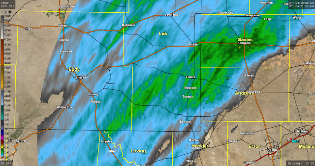
9-29-2019
Looking Northeast From The Artesia WalMart Parking Lot.

(As Of 5:30 AM MDT Monday, Sept 30th, 2019).

24-Hour Totals.


72-Hour Totals.


Thunderstorms dumped heavy rain across parts of the local area again Sunday afternoon. The heaviest rains fell over far southern Lea County along the New Mexico and Texas State line where radar estimated 3" of rain fell. The 72-hour radar estimated totals in the area are as high as 4". 

Widespread Significant Flash Flood Today Into Wednesday.

Heavy To Very Heavy Rainfall Forecast.

WPC Total Rainfall Forecast.

Valid Today Through 6 PM MDT Friday, Oct 4th, 2019. 

GFS Total Rainfall Forecast.

Valid Today Through 6 PM MDT Friday, Oct 4th, 2019. 

NWS NDFD Total Rainfall Forecast.

Valid Today Through 6 AM MDT Thursday, Oct 3rd, 2019. 

NCEP WRF Total Rainfall Forecast.

Valid Today Through 6 PM MDT Tuesday, Oct 1st, 2019. 


Tropical Storm Narda Remnant Moisture Gets Pulled Northward.


Valid At Midnight Sunday Night.


Valid At 6:41 AM MDT This Monday Morning.

Early this Monday morning a deep and cold closed mid-upper level low remained parked over eastern Oregon. Southwesterly flow around the bottom of this winter storm will pull a fetch of deep remnant tropical moisture northward into the area today into Wednesday.

Training Thunderstorms Will Produce Very Heavy Rainfall!


Forecast models are settling down somewhat with their overall total rainfall amounts they are forecasting for this upcoming heavy to very heavy rain event. Although they still are having difficulty nailing down exactly where and how much heavy rain will fall. Be careful in using the graphics above since given a number of factors the heaviest rains may fall in different locations than those currently indicated.

This mornings theme is generally 1" to as much as 4" of rain will fall over the Southeastern Plains, the Guadalupe, Sacramento, and Capitan mountains, and nearby Eastern Plains by Wednesday morning. There will be pockets of heavier rainfall in these areas and if the models are to be believed the heaviest totals may end up in the 5" to 10" range. This isn't all that far fetched historically and considering 3" to 4" have already fallen the past three days over parts of the local area.

Repeat thunderstorms over the same locations or otherwise known as "training thunderstorms" will have the potential to dump excessive amounts of rainfall. Life Threatening Flash Flooding will be possible over a wide area of the region this afternoon into Wednesday morning. Many parts of the local area are already saturated from recent heavy rains and it won't take much for flash flooding to occur. 

Widespread flash flooding from the Guadalupe, Sacramento, and Capitan mountains eastward will be possible this afternoon through Wednesday. Many of our normally dry arroyo's may flood. River flooding on the Rio Penasco, the Hondo, the Rio Ruidoso, Black River, Delaware River, and Pecos rivers may also occur.

Tonight will be an especially dangerous time when heavy rains are forecast to be widespread. There are literally thousands of low water crossings the crisscross through local normally dry arroyo's. These arroyo's will the have the potential to flood rapidly and some water depths in the past have been known to exceed 10' to 25'. 

Our local area has been inundated with people moving in because of the recent oil field boom. Many of them may not be aware of the flash flood threat we have from time to time. 

Please talk to your friends, neighbors, co-workers and relatives about this danger. Remember never drive through a flooded arroyo, low water crossing, flooded city streets and intersections, or other flood prone areas. This is especially true at night when its nearly impossible to tell the depth of the flood waters. It only takes about 18" to 2' of rapidly flowing flood waters to float a normal size vehicle away.

Southeastern New Mexico, West Texas, and nearby areas have a long history of flash flood events. Some of which have resulted in flash flood drownings. 

TURN AROUND - DON'T DROWN!

Severe Thunderstorms Again Today.

Scattered to numerous thunderstorms are expected to once again fire up by early afternoon and persist into tonight. Some of these will become severe and produce large hail, damaging thunderstorm wind gusts in excess of 60 mph, deadly cloud to ground lightning, and heavy to very heavy rainfall that will cause flash flooding.

WHEN THUNDER ROARS - GO INDOORS!

The Truth Is Stranger Than Fiction - And Sometimes It Hurts!

Sunday, September 29, 2019

Significant/Major Flash Flood Event Potentially Shaping Up This Week.


Sept 28th, 2019.
Looking Southeast From Near Lakewood/Seven Rivers.


As Of 6 AM MDT Sunday, Sept 29th, 2019.

NWS New Mexico Estimated 48-Hour Rainfall Totals.

As Of 6 AM MDT Sunday, Sept 29th, 2019.

New Mexico 24-Hour Lightning Strikes.

As Of 8:15 AM MDT Sunday, Sept 28th, 2019.

New Mexico 24-Hour Lightning Strikes.

As Of 8:15 AM MDT Sunday, Sept 28th, 2019.


Thunderstorms have been busy over parts of Southeastern New Mexico and West Texas the past couple of days. A Severe Thunderstorm dropped quarter (1" diameter) to hen egg size hail (2" diameter) on Hobbs Saturday afternoon around 6:15 PM MDT.

Last night a little after 11 PM MDT a Severe Thunderstorm rolled across southern Carlsbad producing hail that ranged in size from quarters (1" diameter) to hen eggs (2" in diameter). 

Thunderstorms have been most concentrated over the far Southeastern Plains and eastward into nearby West Texas the past couple of days...take a look at the lightning strike maps above.

NWS Regional MesoNet Reported & Radar Estimated Rainfall Totals.


24-Hour Totals As Of 8 AM MDT Sunday, Sept 29th, 2019.

48-Hour Totals As Of 8 AM MDT Sunday, Sept 29th, 2019.

Our latest round of thunderstorms have dropped beneficial rains across parts of the local area with the heaviest totals having mostly fallen in Lea County and parts of nearby West Texas. With the expected coming heavy rains the flash flood threat will greatly increase Monday into perhaps Wednesday over the local area. This will include the Guadalupe, Sacramento, and Capitan mountains and parts of southern New Mexico.

 Upper Air Pattern & Tropical Storm Narda Complicates Weather Forecasts This Week.


Oh surprise look how far south the cold closed upper-level low has dropped overnight. I'm not surprised by this since the models tend to have a hard time with storms of this magnitude and strength...especially when they are this strong and cold this early in the season. Our local weather will be impacted by this southern dip of the storm.

US GFS 500 MB/18,000' Forecast.

Valid At 6 PM MDT Monday.


Valid At 9:30 AM MDT Sunday, Sept 29th, 2019.


Remnant Moisture From Tropical Storm Narda To Have Huge Local Impacts Locally!

Remnant Moisture From Tropical Storm Narda Will Complicate Our Forecasts This Week.

Time to throw in a couple of kinks into our local forecasts for the upcoming week. First of all the cold closed upper-level storm centered over southern Oregon and northwestern Nevada this morning has moved further south than the models have been forecasting. Why is this important? Because now the strong southwesterly flow aloft around the storm has a better chance of snagging more of the tropical moisture from Tropical Storm Narda and pulling it northward into the area this week. 

How much moisture and for how long will have huge impacts on our local weather. What exact track does the closed upper-level low take this week will also be a huge player in all of this. Suffice to say that conditions are ripe for a significant prolonged heavy rain and flash flood event appear in the making for parts of the local area.

How Much Rain Will Fall This Week?


Valid Today Through 6 PM MDT Friday, Oct 4th, 2019.

WPC 7-Day Rainfall Forecast.

Valid Today Through 6 PM MDT Friday, Oct 4th, 2019.

NAM 3 KM 3-Day Regional Rainfall Forecast.

Valid Today Through 6 PM MDT Tuesday, Oct 1st, 2019.

NAM 3 KM 3-Day New Mexico Rainfall Forecast.

Valid Today Through 6 PM MDT Tuesday, Oct 1st, 2019.

NCEP WRF 3-Day Rainfall Forecast.

Valid Today Through 6 AM MDT Tuesday, Oct 1st, 2019.

I'm Worried History May Repeat Itself This Week.


To say that the computer forecast models are struggling with the placement of the heaviest rainfall and how much is an understatement. Such is often the case when dealing with tropical moisture and strong upper-level systems. Lets complicate matters even further with an approaching cold front that is forecast to arrive mid-week or late week.

Notice that the above computer model total rainfall forecasts are bordering on the extreme in a couple of them. I always try to be careful when using these since they are only a guide. But what bothers me this morning is that all of them basically agree that the area is being set up for very heavy rains to fall by Wednesday...with additional heavy rains possible the end of the upcoming work week.

Rarely do I see the models get this crazy and excessive with overall storm totals. This worries me a great deal. I have doubts as to the placement of the heaviest rains and where they will end up falling. This mornings WRF goes nuts with 22" of rain over Northeastern New Mexico between Tucumcari and Las Vegas. 

Like-wise this mornings run of the NAM 3K model dumps 12" of rain near the Vaughn area by Tuesday at sunset. The GFS model run this morning dumps 6" over the Sacramento mountains and parts of the east-central plains.

Historically local storm totals in the past from similar setups have ranged from 8" to 25". But those are rare events that occur on average about every 25 to 50 years. We faced a similar situation in September 2013 and September 2014. See my main weather web page...scroll down the left hand column until you come to the header: Local Flash Floods. Then click on the listed flash flood events.

For now local storm total rainfall amounts could easily end up totaling 2" to 6" by the end of this upcoming week. Some areas have already received 2" to 3" in the past couple of days. On the high side of rainfall totals I think we may see some spots ending up in the 6" to 12" range if not higher....which will be highly dependent upon what unfolds later this week.

Life Threatening Significant/Major Flash Flooding Event Possible This Week!

Training thunderstorms which track over the same locations multiple times in the coming days will have the potential to greatly elevate the threat for significant widespread flash flooding. Figuring out where is just not possible yet. 

Several days of heavy to excessive rainfall on top of already saturated grounds will add to the mix and and elevate the flash flood dangers across the local area. Anyone living in Southern, Southeastern, Eastern, and even parts of Northeastern New Mexico need to prepare for the possibility of a Significant Or Even Major Flash Flood Threat/Event this week. 

Hundreds if not thousands of people had to be rescued out of the local oil patch and surrounding areas of Southeastern New Mexico and West Texas in September 2014 due to that Historic Flash Flood Event. Many were stranded for up to a week or more.

Could this happen again? Possibly. Will this flash flood event be as bad as 2014? Possibly but determining just where yet is too tough to call. Please continue to monitor your favorite news outlet or media source for all of our local forecasts, watches, and warnings concerning this upcoming event. As always my weather web page auto populates with all of the very latest information from our local National Weather Service Offices.

Remember to be situationally aware of your surroundings, the weather in your area, and stay updated during any and all local Severe Thunderstorm Warnings, Flash Flood Watches, or Flash Flood and Flood Warnings!

Flash Flood Watches may be issued later today into Monday for the local area via our local National Weather Service Offices. 

Severe Thunderstorms Once Again This Afternoon And Evening.


The Truth Is Stranger Than Fiction - And Sometimes It Hurts!

Saturday, September 28, 2019

Rain Fell Upon The Plain Overnight - Much More To Come!


Rain Upon The Plain Overnight.


As Of 4:21 AM MDT This Saturday Morning.

Cannon AFB Radar Estimated 24-Hour Rainfall Totals.

As Of 4:22 AM MDT This Saturday Morning.


As Of 5 AM MDT This Saturday Morning.


As Of 5 AM MDT This Saturday Morning.


As Of 5 AM MDT This Saturday Morning.

The totals highlighted in red indicate the 24-hour total. The light blue shaded totals are since midnight last night.


Active Weather Pattern This Weekend Into Next Week.


This morning national map looks more like a winter scene than a fall one out west. Numerous watches and warnings are in effect ranging from Red Flag Warnings to Winter Storm Warnings. Click on the link to the map to open it up then pick a spot you are interested in on the map and click on it. That will take you to the National Weather Service forecasts, watches, warnings, and much more for your area of interest. This map auto populates so its always update with the latest info.

Big Winter Storm Out West - Summer In The South & East.


Valid At Midnight Last Night.

US GFS 500 MB/18,000' Forecasts.

Valid At 6 AM MDT Sunday Morning.

Valid At 6 AM MDT Monday Morning.

Valid At 6 AM MDT Tuesday Morning.


A deep and cold mid-upper level closed low will essentially remained parked over the Pacifc Northwest states today into Monday. This will aide in clobbering parts of northern Montana and southwestern Canada with incredible amounts of heavy wet snow. 

Parts Of Montana To Get Buried By Heavy Wet Snow!


Snowfall totals are forecast to range from 15" to 36" across the lower elevations of northwestern Montana with 3 to 5 feet in the mountains which will be blown around by wind gusts of up to 50 mph. That's impressive for anytime in the winter and almost unheard of this early in the fall!

Excerpts from the Great Falls, Montana National Weather Service Office forecaster on duty early this Saturday morning in the Area Forecast Discussion (AFD):
  Snowfall amounts have changed very  
  little from previous forecast, as model guidance continues to remain  
  in very good agreement with the evolution of the winter storm.  
  Because of this, have decided to add Hill, Blaine, Choteau, and  
  Fergus Counties to the Winter Storm Warning. While portions of these  
  counties (especially eastern portions) will see lighter snowfall  
  amounts, the mountains and western portions will likely see  
  significant impacts from the heavy, wet snow. Extreme impacts are  
  still expected along the Rocky Mountain Front and portions of the  
  North Central Montana plains through Sunday night due significant  
  accumulations of the heavy, wet snow and strong north to northeast  
  surface winds. Widespread tree damage is possible due to the heavy,  
  wet snow falling onto trees with foliage. Downed power lines are  
  also possible, resulting in widespread power outages that could last  
  days in remote areas where access is limited due to the depth of the  
  snow. Agricultural interests; outdoor  recreational interests,  
  including camping and hunting activities; and travel will also be  
  extremely impacted. Blizzard conditions remain possible along the  
  Rocky Mountain Front and immediate eastern plains tonight through  
  Sunday, but have decided to hold onto the Winter Storm Warnings for  
  now given the heavy ,wet nature of the snow, which may not  
  blow around enough to reduce visibilities below 1/4 mile. - Moldan 

Meanwhile In New Mexico.


Valid Today Through Monday, October 7th, 2019.

GFS 16-Day Temperature & Rainfall Forecasts.


Cooler and much wetter weather remains in our local forecasts this weekend into next week. Our closed low that was parked over the Baja Region has lifted northeastward into northern New Mexico and opened up early this morning as forecast. Enough instability combined with a sharping dryline over the local area, and daytime heating will once again help to kick off scattered thunderstorms this afternoon and evening and again on Sunday.

A few of these thunderstorms may become severe and produce large hail, damaging thunderstorm wind gusts in excess of 60 mph, deadly cloud to ground lightning, locally heavy rainfall along with localized flash flooding. 

Heavy Rains - Flash Flooding Concerns Next Week.


Heavy rains and flash flooding will be a concern Monday into the at least the middle of next week over the area. As the powerful winter-like storm over the Pacific Northwest digs a little further south early next week the flow aloft over New Mexico and the surrounding areas will remain southwesterly. Subtropical moisture is forecast by the models to get pulled northeastward into the Desert Southwest including New Mexico by this southwesterly flow aloft. 

Training thunderstorms or thunderstorms that repeatedly move over a location will elevate the threat for flash flooding as will several days in a row with heavy rainfall. Of course the GFS model currently is the most aggressive with its storm total forecasts locally of 3" to 5" of rainfall fairly widespread over the local area next week. Notice too that our temperatures will cool off over the next week to ten days.


The Truth Is Stranger Than Fiction - And Sometimes It Hurts!

NWS Albuquerque Burn Scar Matrix Forecast

Current NWS Watches/Warnings In Effect

New Mexico

Eddy County

Chaves County Plains & Mtn's

Culberson County

Lea County

Lincoln County

Otero County

Current US Temps

Current US Wind Chill/Heat Index Temperatures

NWS Midland Forecast

NWS Albuquerque Forecast

NWS Albuquerque Forecast

NWS El Paso Forecast

NWS Lubbock Forecast

NWS Lubbock Forecast

Average Daily High/Low Temperatures & Rainfall

Average Daily High/Low Temperatures & Rainfall