Rain Is Back In Our Forecast - Next Week Could Be Really Interesting.
Upper Air Pattern Becoming More Fall-Like.
Valid At Midnight This Wednesday, Sept 18th, 2019.
GFS 500 MB/18,000' Forecast.
Valid At 6 PM MDT Friday.
A short wave trough of low pressure is currently moving southward into the Pacific Northwest. This trough will continue heading south into the Central Rockies before lifting northeast into Wyoming on Friday.
GFS 500 MB/18,000' Forecast.
Valid At 6 PM MDT Saturday.
By sunset Saturday the trough will have moved northeastward into North Dakota and southern Canada as a second short wave trough of low pressure enters the Pacific Northwest.
GFS 500 MB/18,000' Forecast.
Valid At 6 PM MDT Monday.
Come next Monday a closed mid/upper level low will have formed and should be centered somewhere near northern Arizona. The GFS and ECMWF of course don't exactly agree on how all this will unfold exactly.
Just to make life interesting next week the forecast models are trying to latch onto remnant moisture from Tropical Storms Lorena and Mario (both will reach Hurricane strength) and pull it northeast into the Desert Southwest next week.
Valid At 6 PM MDT Monday.
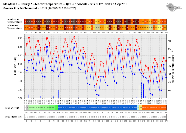
GFS 16-Day Temperature And Rainfall Forecast.
Suffice to say that more changes in our local weather will be coming up as we head towards the weekend and into early next week. Scattered hit and miss thunderstorms will pop up again this afternoon and evening. More widespread coverage is forecast Thursday, Friday, and Saturday. There is the possibility that some of these may become severe along and near the Eastern New Mexico and Texas State line.
How wet do get next week is the big unknown. To that the forecast is complicated is an understatement. Overall the gradual cool down as we slowly head deeper into the meteorological fall continues. Check back later for more details. Thanks for stopping by!
The Truth Is Stranger Than Fiction - And Sometimes It Hurts!


Comments
Post a Comment
Your comments, questions, and feedback on this post/web page are welcome.