My Current Weather

Sunday, January 19, 2020

Cloudcroft & Ruidoso, NM Seasonal Snowfall Totals.


(Oct 1st, 2019 - January 19th, 2020).


January 11th, 2020.
South Of Cloudcroft, New Mexico.

Top 25 Highest Seasonal Snowfall Totals.
(Cloudcroft, New Mexico 8,750').

Seasonal Totals Are From July 1st - July 1st.

Top 25 Highest Seasonal Snowfall Totals.
(Ruidoso, New Mexico 6,950').

Seasonal Totals Are From July 1st - July 1st.

As a kid growing up in Artesia, New Mexico I always was fascinated by the snowfall in the Sacramento mountains. Especially in the Cloudcroft and Ruidoso areas. Many times Cloudcroft would see their first snowfall by Halloween. It was not unusual to see snow on the ground from around Thanksgiving through Easter in many of these years. 

Sierra Blanca Peak (White Mountain or Old Baldy) west of Ruidoso more often than not was coated with snow from before Thanksgiving to after Easter as well. 

If you have been thinking that it does not snow as much in the Sacramento mountains as it used too, then your thinking is correct. Long term snowfall average for Cloudcroft is about 90". 

The last time the Cloudcroft Climate Co-Op Station measured a season total of 100" or more was during the winter of 2009 - 2010 when that station measured 106.6". Since the winter of 2009 - 2010 they have averaged below normal snowfall each winter up to and including this winter (2019 - 2020)...at least so far.

Total Snowfall Totals For The Following Winters In Cloudcroft.

2010 - 2011      25.2"
2011 - 2012      59.7"
2012 - 2013      35.5"
2013 - 2014      38.8"
2014 - 2015      44.2"
2015 - 2016      62.0"
2016 -2017       49.3"
2017 -2018       21.0"
2018 - 2019      58.2"

2019 - 2020 (as of Jan 19th, 2020) 32.3"

Note: There are missing data and gaps in the snowfall record for Cloudcroft and Ruidoso so some of these totals may be too low. 

The same can be said for the Ruidoso area as well. Ruidoso averages about 40" of snow a year. The last winter that Ruidoso saw 40" or more for the season was in 2009 - 2010 when that station recorded 65.6"

Total Snowfall Totals For The Following Winters In Ruidoso.

2010 - 2011        9.2"
  2011 - 2012        21.7"
2012 - 2013       3.2"
2013 - 2014      11.5"
2014 - 2015          M"
2015 - 2016          M"
2016 -2017           M"
2017 -2018           M"
2018 - 2019      36.5"


2019 - 2020 (as of Jan 19th, 2020) 2.6"

I wish that I had the seasonal snowfall records for Ski Apache west of Ruidoso. It would be interesting to compare their snowfall totals in the 1960s, '70s, '80s, and '90s with the past 20 years. 

The Truth Is Stranger Than Fiction - And Sometimes It Hurts!

Sunday, January 12, 2020

A Relatively Mild Winter So Far.


1-11-2020.
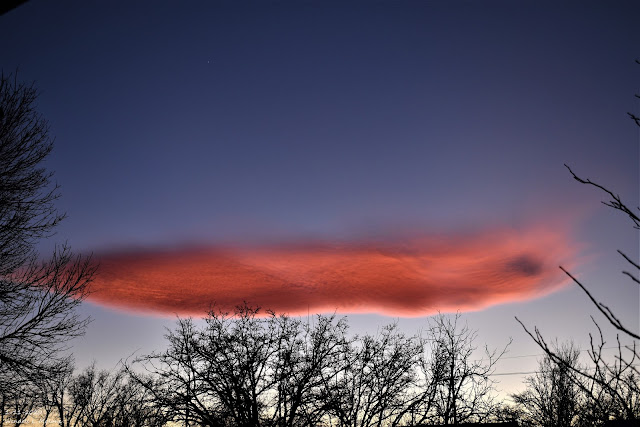
Altocumulus Standing Lenticular Cloud Southwest Of Carlsbad, NM.

Reported Low Temperatures Sof Far This Winter.
(Oct 1st, 2019 - January 12th, 2020).


South-Central Mountains.


Southern New Mexico.


A Mild Winter So Far.

To date, our winter so far hasn't been all that cold or snowy. Cloudcroft officially dropped down to 3ºF Saturday morning for their coldest reading of the season. Here in the Pecos Valley the coldest official low so far this winter has been at the Bitter Lakes Wildlife Refuge with a low of 12ºF on the morning of January 8th, 2020. Artesia has been down to 14ºF on November 1st, Roswell Climate 15ºF on October 31st, Hobbs 16ºF on November 1st, and the Carlsbad Airport 17ºF on December 18th.

Looking back into history we find that on January 11th, 1962 Roswell officially recorded a low of -24ºF. Artesia -20ºF at the KSVP Radio Station located near Hermosa School and -24ºF at the AG Science Center 6 miles south of town. The Carlsbad Airport recorded its all-time coldest temperature of -18ºF and Hobbs dropped down to -7ºF.

Snowfall Is Below Average.


South-Central Mountains.


Southern New Mexico.


(Oct 1st, 2019 - January 12th, 2020).


Locally outside of a couple of light snow showers our snowfall so far this winter is running way below normal to date. Ski Apache (base 9.600') west of Ruidoso is reporting a seasonal total of 50" with a base depth of 38". The Cloudcroft Climate Co-Op Stations has recorded 32.3". None of the reporting stations in the Pecos Valley have reported an inch or more of snowfall except for Hope which is reporting 1.3".

The Truth Is Stranger Than Fiction - And Sometimes It Hurts!

Thursday, January 2, 2020

Snow Tonight Into Thursday?

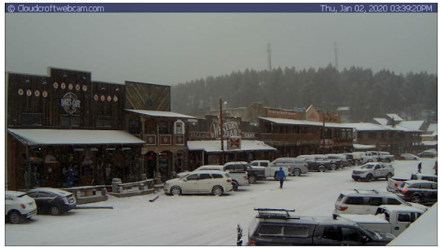
Snowing In Cloudcroft & Ruidoso.


Albuquerque NWS. 


Cannon Air Force Base.


Holloman Air Force Base.


El Paso NWS.


Midland NWS.

At 3:30 PM MST This Wednesday Afternoon.


At 3:30 PM MST This Wednesday Afternoon.


Valid At 2 PM MST Wednesday Afternoon.

Will Rain Change To Snow Tonight?

As of 3:30 PM MST this Wednesday afternoon light to moderate snow was falling in the Sacramento mountains in Cloudcroft, Ruidoso. It was also falling in the La Luz area and Alamogordo areas. 

Temperatures in the mountains are in the 20's and 30's while across southern New Mexico including the Tularosa Basin temps are in the 30's and 40's. Here in Southeastern New Mexico temps are in the upper 30's in the Clovis and Portales areas, the upper 40's in the Roswell area, and the 50's elsewhere except in the Queen and Guadalupe Pass areas where it is in the 30's. It's 38 in Dunken.

A strong jet stream at 30,000' (150 knots or 173 mph) continues driving a strong short wave southward across southwestern New Mexico late this afternoon. Some of the forecast models briefly close this system off into a small closed low just south and west of SE NM tonight into early Thursday morning. This means this approaching Winter Storm has the potential to strengthen some more.

None of the short-range models (in my opinion) are handling this approaching storm very well. Current forecasts call for 3" or so of new accumulations tonight into early tomorrow morning over the Sacramento and Guadalupe mountains. Snow levels are forecast to drop down to around 5,000' tonight. 

Note: Snow levels are already down to around 4,000' in the Tularosa Basin as of 3:30 PM this afternoon. So I highly suspect that that will be the case here in Southeastern New Mexico later tonight into Thursday morning also. I think rain will eventually change over to snow locally. I would not be surprised to see some places end up with a couple of inches here in the lower elevations and perhaps more than is currently forecast in the mountains.


Special Weather Statement
National Weather Service El Paso Tx/Santa Teresa NM
256 PM MST Thu Jan 2 2020

NMZ412-414>416-022300-
Central Tularosa Basin-
West Slopes Sacramento Mountains Below 7500 Feet-
Sacramento Mountains Above 7500 Feet-
East Slopes Sacramento Mountains Below 7500 Feet-
Including the cities of Alamogordo, Tularosa,
White Sands Monument, Mescalero, Timberon, Mountain Park,
Cloudcroft, Sunspot, Apache Summit, Mayhill, Pinon,
and Sacramento
256 PM MST Thu Jan 2 2020

...Snow Falling Across Otero County New Mexico...

At 250 PM mostly light to moderate snow was falling across much
of northern Otero County New Mexico including over
Cloudcroft...Alamogordo...La Luz and surrounding locations.

Up to 3 inch accumulations may occur on mountain areas above 7000
feet with up to an inch possible lower elevations including the
Alamogordo vicinity. Icy slippery roads and low visibility may
therefore produce hazardous driving conditions.

$$

Rogash

URGENT - WINTER WEATHER MESSAGE
National Weather Service Midland/Odessa TX
205 PM CST Thu Jan 2 2020

.ACCUMULATING SNOW IN THE GUADALUPE AND DAVIS MOUNTAINS ABOVE
5500 FEET LATE TONIGHT THROUGH EARLY FRIDAY MORNING...

NMZ027-TXZ270-271-277-031015-
/O.NEW.KMAF.WW.Y.0001.200103T0300Z-200103T1500Z/
Guadalupe Mountains of Eddy County-
Guadalupe Mountains Above 7000 Feet-
Guadalupe and Delaware Mountains-Davis Mountains-
Including the cities of Queen, Pine Springs, and Fort Davis
205 PM CST Thu Jan 2 2020 /105 PM MST Thu Jan 2 2020/

...WINTER WEATHER ADVISORY IN EFFECT FROM 9 PM CST /8 PM MST/
THIS EVENING TO 9 AM CST /8 AM MST/ FRIDAY...

* WHAT...Snow expected. Total snow accumulations of up to one to
  three inches.

* WHERE...Guadalupe and Davis Mountains above 5500 feet.

* WHEN...From 9 PM CST /8 PM MST/ this evening to 9 AM CST /8 AM
  MST/ Friday.

* IMPACTS...Plan on slippery road conditions. Low visibility in
  fog and snow are also likely. The hazardous conditions could
  impact the morning travel.

PRECAUTIONARY/PREPAREDNESS ACTIONS...

If you must travel, keep an extra flashlight, food, and water in
your vehicle in case of an emergency.

&&

The Truth Is Stranger Than Fiction - And Sometimes It Hurts!

Wednesday, January 1, 2020

Mild & Breezy Today - Next Winter Storm Affects The Area Thursday.


Blog Updated:
 At 1:21 PM MST Wednesday, January 1, 2020.
At 2:56 PM MST Wednesday, January 1, 2020.

December 12th, 2019.
Looking back to the north at ground fog lifting out over Whites City.

Happy New Year!

Here's wishing everyone a Happy New Year. With a heartfelt thanks to all of you who take the time to read my blog posts. As of this morning, my blog stats stand at 1,350,072 unique visits to my weather web page since June 2010. Add another 57,000 visits to that prior to 2010 when I wasn't using bloggers stats and I've had some 1,407,000+ visits. I'm humbled by this and truthfully I never dreamed that I would create this much interest when I created my web page. 

Quick Hitting Winter Storm Thursday.


At 5 AM MST This New Years Morning.

European (ECMWF) 500 MB (18,000') Forecast.

Valid At 5 AM MST Thursday, January 2, 2020.

At sunrise, this New Years' morning a deep cutoff mid-upper level low was located west of the southern tip of Baja, California. This morning run of the European model digs this storm southeast today into sunrise Thursday morning while opening it up into a trough of low pressure and weakening it.

At the same time, a short wave trough of low pressure at the 18,000' level is forecast to dive southward from northwestern Montana into the southern Rockies and New Mexico by sunrise Thursday morning. 

Valid At 5 PM MST Thursday, January 2, 2020.

As the closed low weakens the shrot wave trough approaching from the north will merge with it over New Mexico on Thursday.

Valid At 5 AM MST Friday, January 3, 2020.

These mornings Canadian and GFS models have similar forecasts with the GFS a little deep and further north with the closed low at sunrise Friday morning. 


Valid At 5 AM MST Thursday, January 2, 2019.


Valid Today Through 5 AM MST Friday, January 3, 2020.


NWS NDFD Storm Total Rainfall Forecast.


Our inbound quick-hitting Winter Storm will be somewhat moisture-starved and should not linger around long enough to drop heavy snow over the area. Snow levels across the local area should drop down to around 5,000' tonight. Current forecasts call for a couple of inches of new snow across the higher elevations of the Sacramento mountains tonight into Thursday. With a dusting possible in the Guadalupes and across southern New Mexico. 

Roswell and nearby areas, as well as northern Lea County, may see a light mix of rain and snow Thursday. But as of this writing (Wednesday at noontime), no significant accumulations are expected. 


This Map Was Updated At 2:56 PM MST Wednesday, January 1, 2020.

Valid Today Through 5 PM MST Thursday, January 2, 2020.


Today through Thursday west winds sustained at 45 to 55 mph with gusts near 70 mph!

West winds are forecast to become sustained at 25 to 35 mph with gusts near 55 mph today across the Eastern Plains of New Mexico. These winds will shift around to the north and northeast tonight behind the frontal passage. Westerly gusts to near 70 mph may occur near and over the Guadalupe mountains today into Thursday night.  

NWS NDFD Forecast High Temperatures. 

Thursday.


Friday.


Latest model forecasts are calling for a southward moving cold front to enter the Southeastern Plains around sunrise Thursday morning. Cooler air will overspread the area behind the front Thursday and Friday. Today's forecast highs locally are in the 60's with highs on Thursday and Friday expected to be in the 50's across the plains.


Artesia, New Mexico.


Looking down the road it would appear that no earth-shattering or news-making weather is headed our way anytime soon. Temperatures should be close to seasonal averages with the usual up and swings at times.

The Truth Is Stranger Than Fiction - And Sometimes It Hurts!

NWS Albuquerque Burn Scar Matrix Forecast

Current NWS Watches/Warnings In Effect

New Mexico

Eddy County

Chaves County Plains & Mtn's

Culberson County

Lea County

Lincoln County

Otero County

Current US Temps

Current US Wind Chill/Heat Index Temperatures

NWS Midland Forecast

NWS Albuquerque Forecast

NWS Albuquerque Forecast

NWS El Paso Forecast

NWS Lubbock Forecast

NWS Lubbock Forecast

Average Daily High/Low Temperatures & Rainfall

Average Daily High/Low Temperatures & Rainfall