My Current Weather

Sunday, December 29, 2013

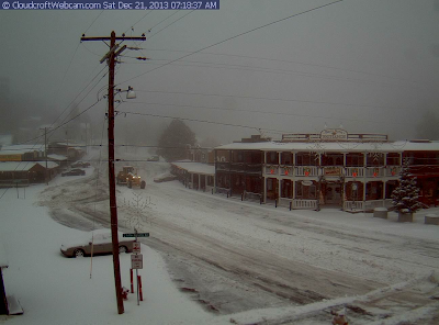
Front Has Arrived - Colder Today.
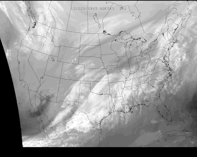

Valid @ 5 PM MST Today.

As of 5 AM MST this morning the arctic cold front had passed through all of southeastern New Mexico. Colder air will overspread the area today behind the front with our afternoon highs only forecast to be in the upper 30's to the low-mid 40's.

The Truth Is Stranger Than Fiction! 

 My Web Page Is Best Viewed With Google Chrome.

Saturday, December 28, 2013

Beautiful Today - Turning Windy & Colder Sunday.

Blog Updated @ 9:41 AM MST.

Visible Satellite Image @ 8:45 AM MST This Morning.

Dense fog and freezing fog developed over parts of southeastern New Mexico and west Texas early this morning. This Visible Satellite image depicts this very well. Local visibility's have dropped down to under a 1/4 of a mile in some locations.

Cottonwood Checked In With A Low Of 16 This Morning.
This Is The Coldest Temp I Could Find In SE NM.


Low temperatures across southeastern New Mexico were close to seasonal normal's this morning. My low temp here at our home in Carlsbad was 21.


 A nice day is in store for the area today with highs in the 50's to near 60

Roswell, NM Temp Forecast.

Artesia, NM Temp Forecast.

Carlsbad, NM Temp Forecast.

Hobbs, NM Temp Forecast.

Ruidoso, NM Temp Forecast.

Early tomorrow morning a cold front will move southward into the local area...thus knocking our high temps back down into the mid 30's to the 40's across the southeastern plains. As is usually the case strong gusty northerly winds will accompany the frontal passage and there may be a few localized areas of blowing dust. 

The Truth Is Stranger Than Fiction! 

 My Web Page Is Best Viewed With Google Chrome.

Friday, December 27, 2013

2013 Rainfall Totals For New Mexico - One Extreme To The Other.


Rainfall over New Mexico was highly variable in 2013. Southeastern New Mexico rainfall totals especially show this variability. Extreme east-central Eddy County near the Lea County line are estimated to have received up to around 25" of rainfall this year. I believe this to be a reasonable estimation.

 Check out the CoCoRaHS and National Weather Service Climate Co-Op rainfall (courtesy of the Midland, Albuquerque, and El Paso NWS Offices) totals for 2013.

Queen 33.3 WSW Carlsbad 27.58"
Carlsbad 3.4 N 17.29"
Carlsbad 6.8 NW 16.57"
Carlsbad 2.1 NNW 16.35"
Carlsbad 2.2 N 16.27"

Like most of New Mexico not all of Eddy County had heavy rain.

Carlsbad Airport 11.38"
Carlsbad Climate 10.84"
Artesia 15.5 S 10.60"
Carlsbad 17.1 NW 9.71"
Artesia 6 S 9.61"
Artesia 3.5 NNE 8.33"

Its a little crazy how heavy rains favored isolated areas this year while most of southeastern New Mexico, like most of the rest of the state, saw near average to below average rainfall for the year. 

Chaves and Lea Counties did not receive nearly as much rain as parts of Eddy County did.

Roswell 17.4 N 12.60"
Roswell 3.5 WNW 11.20"
Roswell 4.1 NNE 11.06"
Roswell 0.3 SSW 10.97"
Roswell Airport 9.45"

Hobbs 8.0 SSE 12.74"
Tatum 1.7 SW 12.17"
Monument 1.2 W 12.13"
Hobbs Climate 8.45"

The wettest location that I have been able to find is the CoCoRaHS Station that is located 4.7 miles east of Cloudcroft with a total of 37.88". While the Cloudcroft Climate Co-Op Station has recorded 28.67".

 A station located 1.7 miles WNW of Ruidoso recorded 23.09" while the Ruidoso Climate Co-Op Station recorded 16.42".

Just east of Mayhill at the Elk that Climate Co-Op Station they have recorded 14.97"

Drought To Continue Across New Mexico.


For all intents and purposes New Mexico remains in a drought with much of the state in the Severe category. This in spite of the localized heavy rains across parts of the state this summer and fall.


Three days of very heavy rain produced widespread flash flooding across parts of southeastern New Mexico. Chaves County was hit hard on Wednesday, September 11, 2013. Eddy County had its turn today Thursday, September 12, 2013. Over 13 inches of rain was reported in the Pine Springs area, and over 10 inches was reported in the Queen area. Over 9 inches of rain also fell 11 miles northwest of Carlsbad. Widespread 2" - 4" amounts were common across the Pecos Valley.

I was wrong on the location in this video. I shot this at the junction of Boyd Drive and Radio Blvd in Carlsbad, New Mexico.

I will end the year at 16.35" here at my home in Carlsbad. July was a very wet month for me with 5.46" of rain falling. September was a close second with 4.56"

Exceptionally heavy rains fell in the Guadalupe mountains from September 9th through the 13th. An automated rain gauge located in Pine Springs (GUMO Mesonet Station) recorded an astonishing 15.76" of rain. Incredibly 13.62" of this fell in the 24-hour period between the 11th and 12th of the month, with most of this falling in 12-hour period during the early morning hours of the 12th! Meanwhile the Queen CoCoRaHS Station measured 11.95" of rain overnight.

Widespread flash flooding occurred across southeastern New Mexico due to these and other heavy rains that fell that week.

For additional information and photos on this event please visit my blog list for September of this year, which is located on the very right hand side of my web page, and is listed under "Blog Archive. "

The Truth Is Stranger Than Fiction! 

 My Web Page Is Best Viewed With Google Chrome.

Thursday, December 26, 2013

Colder Weather Coming? (+playlist)


Its Not CO2 - Its The Sun!

200 years of high Sunspot activity is coming to an end, just as the Sun comes to the end of its 22 year long Sunspot Cycle. Global Cooling is coming not Global Warming.

The Truth Is Stranger Than Fiction!

My Web Page Is Best Viewed With Google Chrome.

Bite-Sized Science: The mPING App


Everybody talks about the weather. And we all know that the weather that you may be experiencing is not always the same that your family or friends may be experiencing at times. 

Now you can report your local weather conditions from your current location via your smart phone, to your local National Weather Service Forecast Office. Simply download the App which is free, and then enter your current weather from your current location. Your reports will aide them in getting a clearer picture of your local weather...not just what the radar is seeing.

The Truth Is Stranger Than Fiction!

My Web Page Is Best Viewed With Google Chrome.

Saturday, December 21, 2013

Upper-Level Low Over West Texas.


Cool shot of the upper-level low located over west Texas.

The Truth Is Stranger Than Fiction! 

 My Web Page Is Best Viewed With Google Chrome.

Meteorologist Joe Bastardi Warned Of A Cold 2013-2014 Winter In 2010.


The Truth Is Stranger Than Fiction!
My Web Page Is Best Viewed With Google Chrome.

Local Rainfall & Snowfall Totals.

Snow Falling Across The Sacramento's. 


 Cloudcroft measured 7.1" of snowfall overnight, as of 7 AM MST anyway. The top photo above shows them fogged in at 7:18 AM MST this morning. At 8:50 AM MST this morning snow was once again falling. As per the El Paso NWS Facebook Page they have now picked up a total of 8"of snow from this storm. Additional snowfall reports via the CoCoRaHS Network are available...as well as courtesy of the Albuquerque National Weather Service Office


As of Noon MST Ski Apache had picked up 6" of snow from the storm and its snowing hard again. This brings their season snowfall total to 21.2".

7" Of New Snow This Morning @ Ski Cloudcroft.


This mornings GFS 500 millibar analysis, visible, and water vapor satellite images show that the closed upper-level low was located over the Sacramento mountains. It is beginning to open up while pull off to the northeast. Wrap around moisture is producing snow across the Sacramento mountains.

Rainfall Totals.


Valid As Of 7 AM MST This Morning.

Could The Winter Of 2013 - 2014 Be A Cold One?

Meteorologists Joe Bastardi with WeatherBell Analytics warned that the winter of 2013-2014 could be a brutal one back in this video that he taped in 2010.

For The First Twenty Days Of The Month.

Into The First Week Of January 2014.

We are certainly are off to a cold start so far this December...the first twenty days of the month have been colder than normal across the country. Even though we've seen a recent warming and thawing period across the nation...long-range models and indicators are pointing to a reloading of the arctic invasions that we experienced the first couple weeks of the month in the weeks ahead. 

The Truth Is Stranger Than Fiction! 

 My Web Page Is Best Viewed With Google Chrome.

Friday, December 20, 2013

Our Storm Has Arrived - Moderate Rains Over SE NM.


Temperatures @ 11 AM MST Today.


Valid @ 5 PM MST This Afternoon.

Cloudcroft picked up about 1/2" of snow earlier this morning but currently has stopped (as of 12:45 PM MST anyway) via their Web Cam. Rain has overspread the southeastern plains of New Mexico. At times it has been moderate to heavy in a few spots. As of 1:13  PM MST this afternoon I have measured .21" here at my home in Carlsbad. 

Light Freezing Rain has been reported in the Tatum area with some light accumulation on exposed surfaces. The latest temp in Tatum at 1 PM MST was 32F.

We will see a continuation of the rain across the local area through sunset it appears. The HRRR model is currently forecasting the heaviest rains to occur by around sunset with totals by then averaging around .50" to .75" across most of Eddy County. Lesser amounts in Chaves County and around 1.25" in southeastern Lea County. I take this with a grain of salt though because some of us may see more rain and some of us may see less than rain than what this particular model run is forecasting. 

My temperature here at our home in Carlsbad has dropped down to 41F, this down from 48F earlier this morning, with a light northerly wind. So it appears that the cold front has arrived. We should hold steady with our temps this afternoon and not see to much of a drop in them. 

The Truth Is Stranger Than Fiction! 

 My Web Page Is Best Viewed With Google Chrome.

Heavy Snows For The Sac's - Heavy Snow & Rain For SE NM.


Strong Winter Storm Headed Our Way.


Valid @ 5 AM MST This Morning.

Take a look at the Water Vapor satellite image above. You can see that the center of the closed 500 millibar low was located just west of the central Baja Peninsula at 5:15 AM MST this morning. This is a little further south than what the models had been forecasting. Last nights European (ECMWF) model (graphic above) came fairly close with its forecast at sunrise this morning on the position of the storm. 

There appears be the possibility that this storm is going to continue to dig a little further to the south than originally forecast, slow down in its forward or eastward movement, and possibly deepen some more. Should this happen then we will end up seeing more snow across southeastern New Mexico, and parts of west Texas than is currently being forecast. This has happened many times in the past with these closed or cutoff lows, and could make for a forecasting headache if it happens again this weekend.

Snowfall Forecasts.

Update @ 8:00 AM MST.

This Mornings 12Z/5 AM MST NAM/WRF 
Total Accumulated Snowfall Forecast.
Valid @ 5 PM MST Sunday, Dec 22, 2013.

----------------------------------------------------------------

Now this is interesting...this mornings run of the NAM/WRF model is forecasting 24" of snow for the Cloudcroft area by sunset Sunday. It is also picking up on the snow falling across the eastern and southeastern plains of New Mexico. Check out its forecast snowfall totals for the Sierra Madre mountains in northern Mexico. 

 Accumulated Snowfall Forecast. 
Valid @ 5 AM MST Monday, Dec 23, 2013.

Total Snow Accumulation Forecast.
Valid @ 5 AM MST Sunday, Dec 22, 2013.

There remains many differences in the models concerning our snowfall forecasts. They continue to struggle with this due to their different forecast tracks of the storm, its timing, and the timing on the arrival of the colder air.So I don't have a lot of confidence in any of their snowfall forecasts this morning. Hopefully this mornings model runs will help clear this up.

For now a Winter Storm Warning remains in effect for the southern Sacramento mountains from 3 PM MST this afternoon through 11 PM MST Saturday. Snow levels this afternoon will start out around 7,500' to 8,000' and drop down to around 5,000' by tomorrow morning. Snowfall totals of around 4" - 8" are forecast. I wouldn't be surprised to see some higher totals in the Cloudcroft and Sunspot areas.

A Winter Storm Warning remains in effect from 11 AM MST this morning through 5 PM MST Saturday for the northern Sacramento mountains. Snowfall totals of 4" - 9" are currently being forecast with over a foot of snow possible above 8,500'. This will be great news for Ski Apache and just in time for Christmas. 

Therefore the Albuquerque National Weather Service Office has issued a Winter Storm Watch for parts of the eastern and southeastern plains. Including Roswell, Portales, Clovis, and Tucumcari.  Snowfall totals of more than 4" will be possible late tonight into Saturday afternoon.

Heavy snow, blowing and possibly drifting snow blown about upon northwest to north winds of 15-25 mph with gusts near 40 mph may cause some travel problems across the eastern and southeastern plains, as well as across the Sacramento mountains tonight into Saturday. Please visit the New Mexico Roads Website for the latest road conditions. 

Valid @ 5 AM MST Monday, Dec 23, 2013.

Rainfall Forecasts.

We still appear on track to see moderate to locally heavy rain across parts of the area today into Saturday. Widespread light to moderate rainfall should occur in most places with storm totals of .50" to 1.00" possible.

Isolated thunderstorms will also be possible across the local area today into tonight. Its even possible that a few of these could even produce some small hail. 

 However there may be a fly in the ointment...as was discussed above. Should the upper-level storm to our west slow down, and dig a little further south, then we would see more of the lower elevations of southeastern New Mexico and parts of west Texas seeing snow later tonight into Saturday.

Just who gets snow and who gets rain from this storm here in southeastern New Mexico is still up in the air this morning. I expect to see some changes in the model forecasts later today which could possibly cause some changes in our local weather forecasts. 

Thanks again for checking out my blogs and visiting my web site...stay safe and be careful out there all.

For The Very Latest Info On This Winter Storm 
Please Visit These NWS Web Pages-


The Truth Is Stranger Than Fiction! 

 My Web Page Is Best Viewed With Google Chrome.

NWS Albuquerque Burn Scar Matrix Forecast

Current NWS Watches/Warnings In Effect

New Mexico

Eddy County

Chaves County Plains & Mtn's

Culberson County

Lea County

Lincoln County

Otero County

Current US Temps

Current US Wind Chill/Heat Index Temperatures

NWS Midland Forecast

NWS Albuquerque Forecast

NWS Albuquerque Forecast

NWS El Paso Forecast

NWS El Paso Forecast

NWS Lubbock Forecast

NWS Lubbock Forecast

Average Daily High/Low Temperatures & Rainfall

Average Daily High/Low Temperatures & Rainfall