

Heavy Snows For The Sac's - Heavy Snow & Rain For SE NM.
Strong Winter Storm Headed Our Way.


Valid @ 5 AM MST This Morning.
Take a look at the Water Vapor satellite image above. You can see that the center of the closed 500 millibar low was located just west of the central Baja Peninsula at 5:15 AM MST this morning. This is a little further south than what the models had been forecasting. Last nights European (ECMWF) model (graphic above) came fairly close with its forecast at sunrise this morning on the position of the storm.
There appears be the possibility that this storm is going to continue to dig a little further to the south than originally forecast, slow down in its forward or eastward movement, and possibly deepen some more. Should this happen then we will end up seeing more snow across southeastern New Mexico, and parts of west Texas than is currently being forecast. This has happened many times in the past with these closed or cutoff lows, and could make for a forecasting headache if it happens again this weekend.
Snowfall Forecasts.
Update @ 8:00 AM MST.
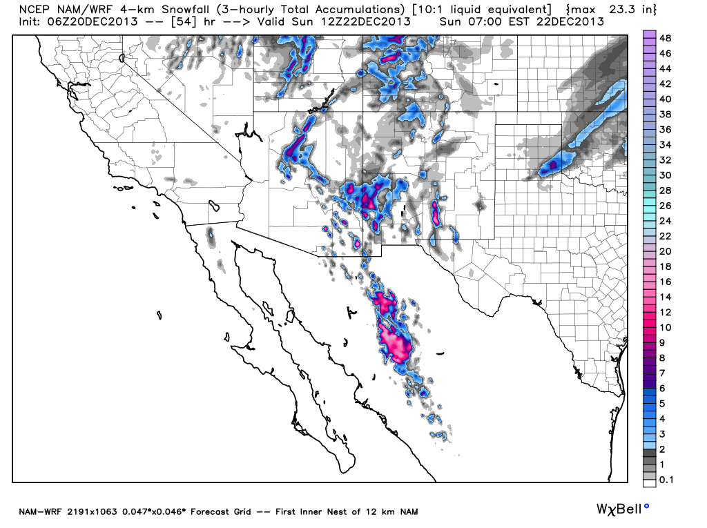
 This Mornings 12Z/5 AM MST NAM/WRF
Total Accumulated Snowfall Forecast.
Valid @ 5 PM MST Sunday, Dec 22, 2013.
----------------------------------------------------------------
Now this is interesting...this mornings run of the NAM/WRF model is forecasting 24" of snow for the Cloudcroft area by sunset Sunday. It is also picking up on the snow falling across the eastern and southeastern plains of New Mexico. Check out its forecast snowfall totals for the Sierra Madre mountains in northern Mexico.
Update @ 8:00 AM MST.

Total Accumulated Snowfall Forecast.
Valid @ 5 PM MST Sunday, Dec 22, 2013.
----------------------------------------------------------------
Now this is interesting...this mornings run of the NAM/WRF model is forecasting 24" of snow for the Cloudcroft area by sunset Sunday. It is also picking up on the snow falling across the eastern and southeastern plains of New Mexico. Check out its forecast snowfall totals for the Sierra Madre mountains in northern Mexico.

Accumulated Snowfall Forecast.
Valid @ 5 AM MST Monday, Dec 23, 2013.
Total Snow Accumulation Forecast.
Valid @ 5 AM MST Sunday, Dec 22, 2013.
There remains many differences in the models concerning our snowfall forecasts. They continue to struggle with this due to their different forecast tracks of the storm, its timing, and the timing on the arrival of the colder air.So I don't have a lot of confidence in any of their snowfall forecasts this morning. Hopefully this mornings model runs will help clear this up.
For now a Winter Storm Warning remains in effect for the southern Sacramento mountains from 3 PM MST this afternoon through 11 PM MST Saturday. Snow levels this afternoon will start out around 7,500' to 8,000' and drop down to around 5,000' by tomorrow morning. Snowfall totals of around 4" - 8" are forecast. I wouldn't be surprised to see some higher totals in the Cloudcroft and Sunspot areas.
A Winter Storm Warning remains in effect from 11 AM MST this morning through 5 PM MST Saturday for the northern Sacramento mountains. Snowfall totals of 4" - 9" are currently being forecast with over a foot of snow possible above 8,500'. This will be great news for Ski Apache and just in time for Christmas.
Therefore the Albuquerque National Weather Service Office has issued a Winter Storm Watch for parts of the eastern and southeastern plains. Including Roswell, Portales, Clovis, and Tucumcari. Snowfall totals of more than 4" will be possible late tonight into Saturday afternoon.
Heavy snow, blowing and possibly drifting snow blown about upon northwest to north winds of 15-25 mph with gusts near 40 mph may cause some travel problems across the eastern and southeastern plains, as well as across the Sacramento mountains tonight into Saturday. Please visit the New Mexico Roads Website for the latest road conditions.

Valid @ 5 AM MST Monday, Dec 23, 2013.
Rainfall Forecasts.
We still appear on track to see moderate to locally heavy rain across parts of the area today into Saturday. Widespread light to moderate rainfall should occur in most places with storm totals of .50" to 1.00" possible.
Isolated thunderstorms will also be possible across the local area today into tonight. Its even possible that a few of these could even produce some small hail.
However there may be a fly in the ointment...as was discussed above. Should the upper-level storm to our west slow down, and dig a little further south, then we would see more of the lower elevations of southeastern New Mexico and parts of west Texas seeing snow later tonight into Saturday.
Just who gets snow and who gets rain from this storm here in southeastern New Mexico is still up in the air this morning. I expect to see some changes in the model forecasts later today which could possibly cause some changes in our local weather forecasts.
Thanks again for checking out my blogs and visiting my web site...stay safe and be careful out there all.
For The Very Latest Info On This Winter Storm
Please Visit These NWS Web Pages-
The Truth Is Stranger Than Fiction!
My Web Page Is Best Viewed With Google Chrome.


Comments
Post a Comment
Your comments, questions, and feedback on this post/web page are welcome.