Arctic Shotgun Reloads Again In About 10-Days.
Blog Updated @ 7:38 AM MST Tuesday, Dec 10, 2013.
Regional Temperatures @ 6 AM MST This Morning.
Regional Temperatures @ 6 AM MST This Morning.
Clayton, NM.
Albuquerque, NM.
Santa Fe, NM.
Cannon AFB Clovis, NM.
Lubbock, TX.
Roswell, NM.
Sierra Blanca Regional Airport - Ruidoso, NM.
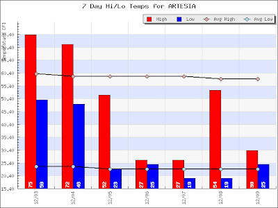
Artesia, NM.
Carlsbad, NM.
Hobbs, NM.
Midland, TX.
New Daily Lowest Maximum Temperatures-
Saturday, December 7, 2013.
Sunday, December 8, 2013.
Friday, December 6, 2013.
2013 Deep Freeze.
As of 7:00 AM MST Tuesday morning, December 10, 2013 the Angle Fire, New Mexico airport had dropped down to -21F for a low temperature. The Jicarllia Ranger Station HADS (7,024' MSL) located east of Farmington had dropped down to -25F. The Hidden Valley Raws in the Valles Caldera (8,470' MSL), west of Los Alamos had dropped down to -29F.
Southeastern New Mexico as well as the rest of the area will crawl out of the ice box beginning tomorrow. Believe it or not but there have been other cold snaps that were both colder and lasted longer than this one we are currently experiencing. And there have been ice storms that were worse than this one also.
Roswell's coldest December high temperatures is listed as 12F set on December 24, 1983. Their lowest recorded temperature for December is -10F that was set on December 20, 1909.
Artesia's coldest December high temperatures is listed as 17F set on December 9, 1978, and again on December 25, 1983 Their lowest recorded temperature for December is -13F that was set on December 15, 1987.
Carlsbad's coldest December high temperatures is listed as 17F set on December 25, 1983. Their lowest recorded temperature for December is -4F that was set on December 24, 1953, again on December 29, 1983, and December 15, 1987.
Hobbs coldest December high temperatures is listed as 13F set on December 25, 1983. Their lowest recorded temperature for December is -1F that was set on December 24, 1983.
Tatumn's coldest December high temperatures is listed as 11F set on December 25, 1983. Their lowest recorded temperature for December is -18 that was set on December 29, 1983.
ECMWF Ensemble Control 500 MB Forecast.
Valid @ 5 PM MST Friday, December 20, 2013.
GEFS Ensemble 500 MB Forecast.
Valid @ 5 PM MST Friday, December 20, 2013.
It appears that in about ten days the arctic shotgun is going to reload and fire again. Last night's runs of the GEFS and ECMWF Ensemble models show a cross-polar flow pattern setting up at the 500 millibar level, or roughly 18,000' above sea level, across North America. Should this pattern develop there would be a reasonable chance that mother nature once again would take aim at the lower forty eight, and fire off another round of very cold temps, straight out of the arctic, sending them deep into the nation around the 20th of the month or so.
The Truth Is Stranger Than Fiction!
My Web Page Is Best Viewed With Google Chrome.


Comments
Post a Comment
Your comments, questions, and feedback on this post/web page are welcome.