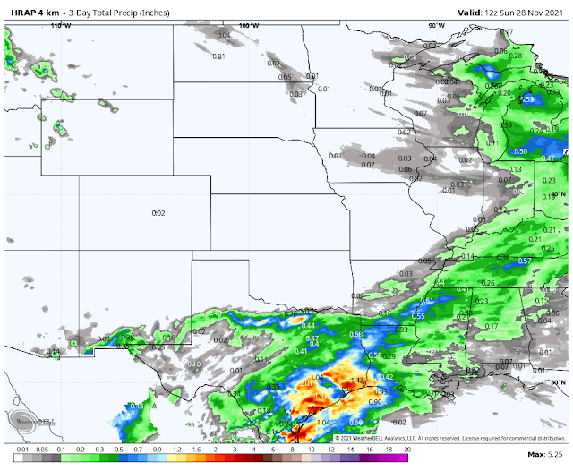
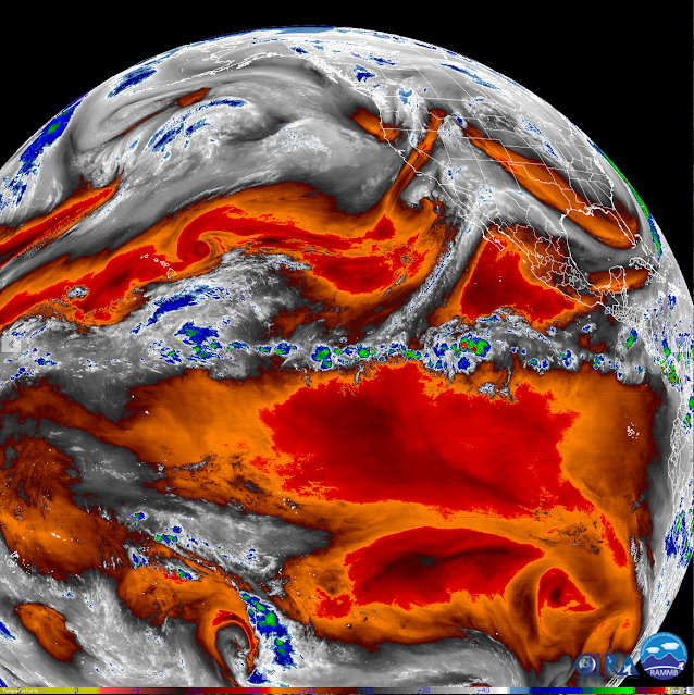
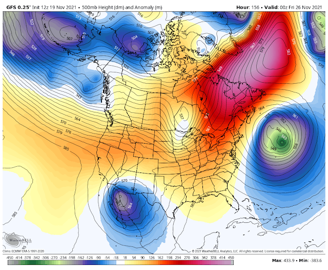
My Current Weather

Friday, November 26, 2021

Round Two Tonight Into Saturday - Lowland Rain Showers & High Mountain Snow.

8:30 AM MST.
November 26, 2021.

Second Phase Of Our Storm Tonight Into Saturday.

Valid At 11 AM MST Saturday.


Valid Today Through 5 PM MST Sunday.

NWS NDFD Precipitation Forecast.

Valid Today Through 5 PM MST Sunday.

Lowland Rain Showers & High Mtn Snow.

Round two of our so-called winter storm comes tonight into Saturday. Cloudcroft and Ski Apache saw a couple inches of snow out of round one that ended yesterday morning. Clouds will increase this afternoon as the closed mid-level low centered over central Baja this morning moves northeastward towards the area.

This low is warm so to speak for this time of the year so snow levels are going to be high tonight into Saturday, generally at or around 8,000'. Another couple of inches of new snow appear likely in the Sunspot, Cloudcroft, and Ski Apache areas. 

Lowland rain showers will develop tonight and spread northeastward over the Southeastern Plains and parts of West Texas. Some areas could pick up around a quarter of an inch of rain or so. Skies will clear Saturday afternoon as the storm weakens and departs the area.

High temps today into Sunday in the lowlands and valleys will be in the low 60's. The Ruidoso and Mayhill areas will see the 50's while the Cloudcroft area remains in the mid 40's. Highs climb another 10-degrees over these values for the area next week.

Next week's weather returns to mild and warmer than normal conditions. No other storms are on the immediate forecast horizon. So it's back to boring but beautiful fall weather.


The Truth Is Stranger Than Fiction!

Wednesday, November 24, 2021

Update On Our Inbound Storm.

Snapshot At 7:39 AM MST.
Wednesday, November 24, 2021.

As Of 7 AM MST This Morning.


As Of 7:30 AM MST This Morning.

Satellite Images This Morning.


At 6:41 AM MST.


At 7:21 AM MST.


At 7:30 AM MST This Morning.

Rain & Snow Impacting NM This Morning.

Round one of our inbound winter storm is impacting parts of New Mexico this Wednesday morning. Decent rainfall totals are being reported in the Albuquerque and Santa Fe areas as of 7:30 AM MST. Rainfall totals in these areas are ranging from around a tenth of an inch up to three-tenths of an inch. Snow levels in New Mexico are high this morning and are generally 9,000' or higher. The snow level will lower this afternoon into Thanksgiving morning. Down to around 5,000' to 6,000' west of the Central Mountain Chain and down to the valley floors in parts of Eastern New Mexico Thanksgiving morning.

Looking at the Ski Apache webcam it looks like around 1/2" to maybe an inch of snow has fallen so far this morning (as of 7:30 AM MST). Both the Ruidoso and Cloudcroft areas were reporting light rain at the time. 

Light rain and snow showers with a few pockets of moderate rain/snow showers will continue off and on over the State today with the activity letting up some this afternoon and evening. This activity will increase in aerial coverage later tonight into Thanksgiving morning. A Pacific cold front will sweep across the state from northwest to southeast today into tonight. Later tonight a backdoor front will move southwestward through the state.

Turning Colder With More Rain & Snow Tonight Into Thanksgiving.


Valid At 9 AM MST Thanksgiving Morning.


Today Through 5 PM MST Thanksgiving Evening.

NAM 3K Forecast Storm Total Snowfall Amounts.

Today Through 5 PM MST Thanksgiving Evening.

WRF Forecast Storm Total Precipitation Amounts.

Today Through 5 AM MST Friday.

WRF Forecast Storm Total Snowfall Amounts.

Today Through 5 PM MST Thanksgiving Evening.

As is sometimes the case the forecast models have underestimated the strength of this inbound winter storm. It still is not expected to become a major winter storm but it has already produced heavier rainfall totals than what was forecast. The models are used as guidance by us folks who forecast and observe the weather. So as conditions have changed I've updated my outlook.

Colder temperatures will envelop the state tonight into Friday. Gusty southwesterly winds will occur today into this evening ahead of the frontal passages. Winds will shift around to the northwest and then northeast late tonight into Thanksgiving morning behind the fronts. Gusts of up around 25-40 mph will be possible.

Ruidoso and nearby areas will see highs today in the mid 50's with the mid 40's on Thanksgiving. Cloudcroft and nearby areas will see the low to mid 40's today and the mid 30's on Thanksgiving. 

The Southeastern Plains will see highs today in the low to mid 70's and the low to mid 50's on Thanksgiving.

Round two comes tonight with the main impacts of the storm expected across the southern half of New Mexico.

Precipitation will continue off and on today over much of the state except for the Southeastern Plains. It will be showery in nature so some areas will see several rounds. The brunt of the storm is forecast to impact the local area late tonight into Thanksgiving. All precipitation is forecast to end by Thanksgiving afternoon.

Locally I think that elevations above 5,000' late tonight into Thanksgiving morning in the Sacramento, Capitan, and the Guadalupe Mountains will see rain over change to snow. Accumulating snow is possible above 5,000' tomorrow morning through just after noontime. Locations above 7,000' could end up with an inch or two of snow. Cloudcroft, Sunspot, and Ski Apache may see more...maybe 3"- 4"?

Rainfall across the Southeastern Plains is still forecast to be on the light side with storm totals of less than a quarter of an inch. A mix of light rain and or snow may be possible across parts of the Southeastern Plains Thanksgiving morning especially near the mountains...although chances of this happening as of this writing are not that great.

Happy Thanksgiving Everyone!

The Truth Is Stranger Than Fiction!

Tuesday, November 23, 2021

Our Thanksgiving Weather Forecast.


At 4:30 AM MST Tuesday, Nov 23, 2021.


At Midnight Last Night Tuesday, Nov 23, 2021.

Our Storm Pulling Moisture In From The Eastern Pacific.

We can see that the subtropical jet stream is pulling mid and high-level moisture northeastward into the closed mid-level low circulation which was located southwest of San Diego early this morning. As this low moves eastward and phases with the long-wave trough of low pressure to its north, it will continue to pull this moisture northeastward into the Desert Southwest and our local area. Mid and high-level clouds will continue to stream across the area today into Wednesday night, thickening and lowering today into Wednesday.


Valid At 5 PM MST Wednesday.

European (ECMWF) 500 Millibar (18,000') Forecast.

Valid At 5 PM MST Thanksgiving.

By sunset, Wednesday a large elongated mid-upper level long-wave trough of low pressure will be entering western New Mexico. The bottom portion of this trough of low pressure is forecast to break off forming a closed low that will drift to the southwest on Thanksgiving and will be centered over the central Baja Peninisula by sunset. The forecast models basically stall this closed low over that area through the upcoming holiday weekend as it slowly weakens. So given this, it means that we will not get the storm we were hoping for but we will see the weaker version of it.

Not The Winter Storm We Need Or Wanted.

Sunday, November 21, 2021

Update On Our Thanksgiving Storm.


At 7:30 AM MST This Sunday Morning.


Cold & Snow Cover Increasing.

Snow cover to our north in Canada and Alaska continues to increase. This will be important as we approach the beginning of the meteorological winter (December 1st) and beyond. Temperatures in western Alaska have already dipped down to the -45F range. As the cold and snow cover continues to build in this region the polar jet stream will occasionally dive southward into the U.S. this winter dragging winter storms and arctic outbreaks into the nation. Not all La Nina winters are the same. My thinking is that we will see some hefty arctic outbreaks this winter along with some decent winter storms here in SE NM and W TX.

Update On Our Thanksgiving Storm.


Valid At 5 AM MST Thanksgiving Morning.

A weak closed mid-upper low is forecast by the models to develop well west of San Diego today. Then strengthen as it is pulled eastward and southeastward towards the northern Baja and southern California area by Tuesday. It then is forecast to phase with a long-wave trough of low pressure to its north stretching from central California northward into the northwestern territories of Canada. By Thanksgiving morning the bottom half of this long-wave trough of low pressure breaks off and develops into a cutoff low or a closed low near the central Baja Region. 

Once again just how far south this cutoff or closed low ends up will determine who gets wet neck of the woods. Too far south and we are left high and dry...which happens sometimes. The latest run of the computer models are doing better but I still expect to see some more changes in their forecasts so nothing is written in stone yet concerning our local forecasts. 


A cold front pushed southward through New Mexico and West Texas overnight. Cooler air will filter in behind it today. Today's high temperatures are forecast to be some 5-degrees below normal locally for the date.

Thanksgiving Week Forecast.

Friday, November 19, 2021

Forecast Models Are Struggling With Our Thanksgiving Storm.


Valid At 5 PM MST Thanksgiving Day.

German (ICON) 500 Millibar (18,000') Forecast.

Valid At 5 PM MST Thanksgiving Day.

Japanese (JMA) 500 Millibar (18,000') Forecast.

Valid At 5 PM MST Thanksgiving Day.

European (ECMWF) 500 Millibar (18,000') Forecast.

Valid At 5 PM MST Thanksgiving Day.

Canadian (GEM) 500 Millibar (18,000') Forecast.


Forecast Models Are Struggling With Our Thanksgiving Storm.

Disagreement in the computer model forecasts remains today's theme. This morning's run of the US GFS and German ICON forecast models are calling for the best chances of seeing meaningful precipitation from next week's potential winter storm. Both of these models develop a closed low over northwestern Mexico Thanksgiving at sunset. The GFS remains the wettest with its forecasts and is calling (at this time anyway) for decent rainfall totals at the lower elevations of the area and modest snowfall totals in the mountains.


Valid At 5 PM MST Thanksgiving Day.

GFS Storm Total Precipitation Amounts.

Valid At 5 PM MST Thanksgiving Day.

GFS Storm Total Snowfall Amounts.

Valid At 5 AM MST Saturday Morning, November 27, 2021.

Still Early To Know For Sure.

We are still six days out from our first potential winter storm to affect the area starting Thanksgiving Day if not sooner. As you can guess this means that confidence in what this storm will or will not produce is still low this far out in time from the event. We may see our first soaking rains across the valleys and moderate snowfall in the mountains next week.  And then again we may not. As always what happens or not is highly dependent upon the exact track and strength of the storm. As well as how much subtropical moisture it is able to import into the area and how cold of a storm it will be. I'll keep you updated with the latest.

The Truth Is Stranger Than Fiction!

Thursday, November 18, 2021

Winter Storm Just In Time For Thanksgiving?

November 5, 2021.
Carlsbad, New Mexico.

(As Of 7:30 AM MST).


A cold front moved south through the area yesterday into last night bringing colder temperatures with it. After seeing high temps hitting record levels the past few days today's readings will be slightly below normal for the date. At sunrise this morning reported low temperatures across the area were chilly with a few single digit readings in the higher mountain valleys of northern New Mexico. Some of the coldest low temperatures of the season are occurring this morning.


November Climate Data.


Like October's readings, November has started off warmer than normal thus far. This may change beginning late next week, however.


Seasonal Snowfall To-Date.


Winter Storm Just In Time For Thanksgiving?

NWS Albuquerque Burn Scar Matrix Forecast

Current NWS Watches/Warnings In Effect

New Mexico

Eddy County

Chaves County Plains & Mtn's

Culberson County

Lea County

Lincoln County

Otero County

Current US Temps

Current US Wind Chill/Heat Index Temperatures

NWS Midland Forecast

NWS Albuquerque Forecast

NWS Albuquerque Forecast

NWS El Paso Forecast

NWS Lubbock Forecast

NWS Lubbock Forecast

Average Daily High/Low Temperatures & Rainfall

Average Daily High/Low Temperatures & Rainfall