

Black Friday Winter Storm Summary 11-27-2022.


November 26, 2022.
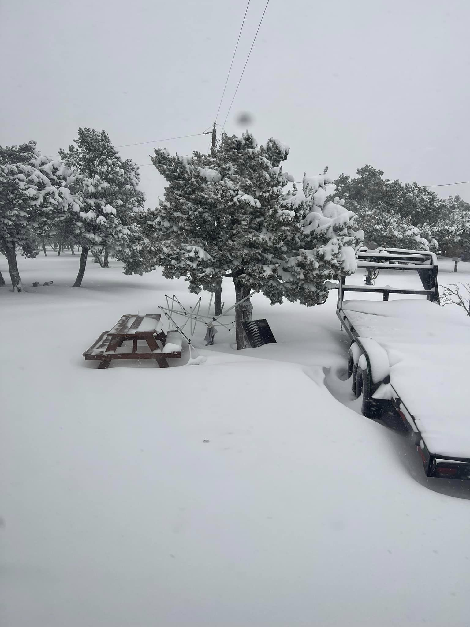
Sitting Bull Falls Recreation Area
42 Miles West Of Carlsbad, New Mexico.
Blog Updated Sunday, Nov 27th, 2022 At 6:00 PM MST.
Blog Updated Sunday, Nov 27th, 2022 At 6:00 PM MST.
Blog Updated Monday, Nov 28th, 2022 At 7:00 AM MST.
Blog Updated Tuesday, Nov 29th, 2022 At 9:05 AM MST.
Blog Updated Friday, Dec 2nd, 2022 At 7:11 PM MST.
Blog Updated Sunday, Dec 24th, 2022 At 8:18 AM MST.
Stunningly beautiful does not come close to describe my drive up to Sitting Bull Falls (elevation 5,000') Saturday morning from Carlsbad. I also shot video of the drive up on my Go Pro Camera and I will share that video when I get done editing.
This has to have been one of the craziest acting snow events I've seen in my lifetime here in Eddy County and the rest of Southeastern New Mexico. And I am 64 years old. I've seen other rain/snow mixed events like this one in the past but none to this extreme. Hard to believe that Queen at 5, 843' got 18" to 20" of snow while Cloudcroft further to the northwest in the Sacramento mountains at 8,750' measured 7.0" from the storm.
Light rain started falling in Carlsbad late Thanksgiving afternoon and evening. By around 2 AM Friday morning it had started mixing with and at times changing over to snow here at our home. A steady cold rain moderate to heavy at times fell continuously from Thanksgiving night through 5:30 AM Saturday morning. All through the day Friday into early Saturday morning we saw this back and forth mix of rain and snow. Sometimes all rain and sometimes all snow. Heavy wet snow with huge snowflakes few Friday morning accumulating to 1/2 of an inch on the ground at our home in Carlsbad. But by noon it was gone. My storm total precipitation for the event was 1.38" with 0.5" of snowfall. My family in Atoka south of Artesia reported 1.48" and a 1/2 of an inch of snow.
Light rain started falling in Carlsbad late Thanksgiving afternoon and evening. By around 2 AM Friday morning it had started mixing with and at times changing over to snow here at our home. A steady cold rain moderate to heavy at times fell continuously from Thanksgiving night through 5:30 AM Saturday morning. All through the day Friday into early Saturday morning we saw this back and forth mix of rain and snow. Sometimes all rain and sometimes all snow. Heavy wet snow with huge snowflakes few Friday morning accumulating to 1/2 of an inch on the ground at our home in Carlsbad. But by noon it was gone. My storm total precipitation for the event was 1.38" with 0.5" of snowfall. My family in Atoka south of Artesia reported 1.48" and a 1/2 of an inch of snow.
My high temp on Friday was only 35º and whenever the temp dropped a degree or two the rain changed over to or mixed with snow. Now here is the really weird part. Carlsbad Caverns National Park located 16 miles southwest of Carlsbad and 1,200' higher up in elevation measured 12.0" of snow! With drifts occurring as well. But by far the biggest winner was Queen located 50 miles west-southwest of Carlsbad at an elevation of 5,843'. They measured 18"-20" of snow! The Mobley Ranch located east of Loving and southeast of Carlsbad measured 6"-8" of snow. Locations up and down, east and west of the Pecos Valley only a couple of hundred feet higher in elevation picked up anywhere from 4" to 12"+ of snow. While the Roswell, Artesia, and Carlsbad areas had less than an inch. That slight difference in elevation combined bit a couple of degrees of colder temps made all of the difference in the world.
Local Storm Total Snowfall Reports.
Queen RV Part & Restaurant 18.0" - 20.0"
Mayhill 13.0"
Weed/Sacramento12.0"
Elk NWS Climate Co-Op Station 12.0"
11 miles east of Cloudcroft on US Hwy 82 (MM 29) 12.0"
Runyan Ranches east of Elk on US Hwy 82 (MM 56) 12.0"
Weed/Sacramento12.0"
Mayhill 2.8 miles west-northwest 11.5"
Sierra Blanca Snotel Near Ski Apache 11.0"
Wimsatt area east of Cloudcroft 11.0"
Elk NWS Climate Co-Op Station 11.0"
Mayhill 2.8 miles west-northwest 10.5"
16 Springs Canyon east of Cloudcroft 10.0"
Arabella 2.5 miles south-southwest 9.0"
White Oaks 6 miles west-northwest 9.0"
Caprock NWS Climate Co-Op Station 8.0"
Cloudcroft 2.3 miles south 7.0"
Cloudcroft NWS Climate Co-Op Station 7.0"
Hope NWS Climate Co-Op Station 6.8"
5 miles east of Cloudcroft 6.0"- 8.0"
Mobley Ranch Southeast Of Carlsbad 6.0" - 8.0"
Young Canyon near Wimsatt, east of Cloudcroft 6.0"
Hibbard Ranch northeast of Pinon in southwest Chaves Co 6.0"
Cloudcroft 0.4 miles east-southeast 5.0"
.
Hope 25.9 miles west-southwest 3.0"
Ruidoso 5.6 miles north-northeast 2.8"
Nogal 4.6 miles south-southeast 1.7"
Cloudcroft 1.8 miles southwest 1.4"
Brantley Dam NWS Climate Co-Op Station 0.5"
2.1 NNW Downtown Carlsbad CoCoRaHS Station 0.5"
La Luz (Otero Co) 5.8 miles east-northeast 0.1"
(Saturday, Nov 26, 2022).


Captured above are visible satellite images of the snow cover in Southeastern New Mexico and parts of West Texas. Note the Pecos Valley is void of snow cover, as was parts of the Hondo Valley east of Ruidoso. Clouds are visible to the right of the snowpack in Lea County.
(Saturday, Nov 26, 2022).


Queen, New Mexico.
(Saturday, Nov 26, 2022).

(Saturday, Nov 26, 2022).
Queen RV Park.

Courtesy Of Staci Reed.
Mobley Ranch Southeast Of Carlsbad, NM.
(Saturday, Nov 26, 2022).

(Saturday, Nov 26, 2022).


(Nov 24 - Nov 27, 2022).


(Nov 24 - Nov 27, 2022).

(As Of 9 AM MST Sunday, Nov 27, 2022).


(Storm Total Rainfall & Snowfall Amounts).
Public Information Statement
National Weather Service Albuquerque NM
1119 AM MST Sat Nov 26 2022

...SNOWFALL REPORTS...

Location                     Amount    Time/Date

...New Mexico...

...Bernalillo County...
Miera 2 ESE                  1.0 in    0800 AM 11/25
Miera 2 SW                   1.0 in    0600 AM 11/25

...Chaves County...
4 E Elk                      8.0 in    0500 AM 11/26
6 NNW Dunken                 4.0 in    0800 AM 11/25

...Curry County...
Melrose                      2.0 in    0715 AM 11/26
Grady                        2.0 in    0900 AM 11/25
1 WNW Clovis                 1.0 in    0700 AM 11/26
1 S Broadview                1.0 in    0944 AM 11/25

...De Baca County...
Yeso                         4.0 in    0500 AM 11/26
11 SW Yeso                   1.0 in    0500 AM 11/26

...Lincoln County...
Arabela 2.5 SSW              9.0 in    0700 AM 11/25
6 WNW White Oaks             9.0 in    0900 AM 11/25
9 SW Corona                  5.0 in    0500 AM 11/26
2 SE Alto                    5.0 in    1241 PM 11/25
Corona                       5.0 in    0900 AM 11/25
2 SE Alto                    5.0 in    0852 AM 11/25
Ruidoso 2.9 SW               4.5 in    0700 AM 11/25
15 ESE Corona                4.0 in    0725 AM 11/25
Alto 0.3 N                   3.5 in    0700 AM 11/25
Corona                       3.0 in    0500 AM 11/26
Ruidoso 5.6 NNE              2.8 in    0700 AM 11/25
Nogal 4.6 SSE                1.7 in    0700 AM 11/25

...Quay County...
1 SW Wheatland               2.5 in    0945 AM 11/25
House 0.1 S                  1.0 in    0700 AM 11/25

...Roosevelt County...
3 E Kenna                    5.0 in    0900 AM 11/25
3 ESE Kenna                  4.0 in    0900 AM 11/25
3 ESE Kenna                  3.5 in    0900 AM 11/26
1 N Elida                    3.0 in    0800 AM 11/26
Elida 5.7 W                  3.0 in    0700 AM 11/25
Portales 2.9 SW              2.0 in    0700 AM 11/25
5 S Lingo                    1.5 in    0800 AM 11/26
Portales 2.9 ESE             1.1 in    0700 AM 11/25

...Torrance County...
11 WNW Cedarvale             7.0 in    0500 AM 11/26
3 NW Cedarvale               6.0 in    0500 AM 11/26
1 N Duran                    5.0 in    0900 AM 11/25
Mountainair 2.2 N            4.2 in    0700 AM 11/25
Mountainair 8 NW             3.5 in    0700 AM 11/25
Duran                        3.0 in    0500 PM 11/25

...PRECIPITATION REPORTS...

Location                     Amount    Time/Date

...New Mexico...

...Chaves County...
Roswell Air Center           0.77 in   1051 AM 11/26
Roswell No. 1 Portable       0.47 in   1040 AM 11/26
Roswell 5.1 N                0.42 in   0800 AM 11/26
Roswell 5.2 N                0.39 in   0800 AM 11/26
Bitter Lake WL Refuge 14 NNE 0.25 in   1037 AM 11/26
Mesa 4 SW                    0.25 in   0800 AM 11/26

...Curry County...
Clovis 4.4 S                 0.75 in   0800 AM 11/26
Cannon AFB                   0.57 in   1055 AM 11/26
Clovis 3 WSW                 0.41 in   1100 AM 11/26
Clovis Muni Airport          0.28 in   1056 AM 11/26
Clovis                       0.25 in   1057 AM 11/26
Ned Houk State Park          0.10 in   1020 AM 11/26


Observations are collected from a variety of sources with varying
equipment and exposures. We thank all volunteer weather observers
for their dedication. Not all data listed are considered official.
Public Information Statement
National Weather Service Albuquerque NM
1145 AM MST Sat Nov 26 2022

...PRECIPITATION REPORTS FOR THE LAST 48 HOURS...

Location                     Amount    Time/Date

...New Mexico...

...Bernalillo County...
Ponderosa 1 WSW              0.14 in   0700 AM 11/25
Chilili 2 N                  0.14 in   0700 AM 11/26
Ponderosa 2 NNW (Oak Flats)  0.11 in   0904 AM 11/25
Miera 2 SW                   0.09 in   0600 AM 11/25

...Chaves County...
Roswell Air Center           0.77 in   1051 AM 11/26
Roswell No. 1 Portable       0.47 in   1040 AM 11/26
Roswell 5.1 N                0.42 in   0800 AM 11/26
Roswell 5.2 N                0.39 in   0800 AM 11/26
Roswell 6.0 NNW              0.38 in   0700 AM 11/26
Roswell 3.4 NNE              0.31 in   0700 AM 11/25
Roswell 28.5 NNE             0.28 in   0700 AM 11/26
Mesa 4 SW                    0.25 in   0800 AM 11/26
Bitter Lake WL Refuge 14 NNE 0.25 in   1037 AM 11/26
Dunken 2 NE (Dunken)         0.21 in   1036 AM 11/26
Roswell 25.3 NW              0.18 in   0700 AM 11/25
Roswell 40.5 NE              0.12 in   0800 AM 11/25

...Curry County...
Clovis 4.4 S                 0.75 in   0800 AM 11/26
Cannon AFB                   0.57 in   1055 AM 11/26
Clovis 3 WSW                 0.41 in   1100 AM 11/26
Clovis 4.4 S                 0.38 in   0800 AM 11/25
Clovis 2.3 NNE               0.31 in   0700 AM 11/26
Clovis Muni Airport          0.28 in   1056 AM 11/26
Clovis 2.6 NE                0.26 in   0700 AM 11/26
Clovis                       0.25 in   1057 AM 11/26
Clovis 3 WSW                 0.24 in   0905 AM 11/25
Ned Houk State Park          0.22 in   0620 AM 11/26
Clovis                       0.15 in   0706 AM 11/26


...De Baca County...
Fort Sumner 9.0 SSE          0.43 in   0700 AM 11/26
Fort Sumner 14.1 W           0.37 in   0600 AM 11/26
Fort Sumner 28.1 SW          0.35 in   0700 AM 11/26
Fort Sumner 0.5 SSW          0.18 in   0700 AM 11/25
Fort Sumner 12 NW            0.18 in   0800 AM 11/25
Fort Sumner 8.9 NNW          0.15 in   0700 AM 11/26

...Guadalupe County...
Newkirk 4.2 N                0.38 in   0730 AM 11/26
Milagro 3 ESE                0.12 in   0700 AM 11/26

...Lincoln County...
Arabela 2.5 SSW              1.05 in   0700 AM 11/25
5.6 SW Bonito Lake (SNOTEL)  0.50 in   0800 AM 11/26
Ruidoso 2.9 SW               0.28 in   0700 AM 11/26
Roswell No. 2 Portable       0.17 in   1020 AM 11/26
Ruidoso 1 NNW (Smokey Bear)  0.17 in   1100 AM 11/26
Ruidoso 5.6 NNE              0.13 in   0700 AM 11/26
Nogal 4.6 SSE                0.13 in   0700 AM 11/26

...McKinley County...
Gallup                       0.27 in   0901 AM 11/25

...Rio Arriba County...
Coyote 7 SSW (Coyote)        0.11 in   0848 AM 11/25

...Roosevelt County...
Causey 11.0 S                1.18 in   0915 AM 11/26
Portales 5.1 SSW             0.99 in   0700 AM 11/26
Portales 2.9 SW              0.75 in   0700 AM 11/26
Portales 2.9 ESE             0.73 in   0700 AM 11/25
Tolar 13 SE (Melrose Range)  0.43 in   0914 AM 11/26
Elida 5.7 W                  0.40 in   0700 AM 11/25
Portales 2.9 SW              0.32 in   0700 AM 11/25
Tolar 13 SE (Melrose)        0.13 in   1014 AM 11/26

...San Miguel County...
8 SW Rociada (SNOTEL)        0.30 in   0100 AM 11/25

...Sandoval County...
Valle Toledo (DRI)           0.12 in   1000 AM 11/26
San Antonio (DRI)            0.10 in   1000 AM 11/26

...Santa Fe County...
Tererro 6 WNW (SNOTEL)       0.40 in   0800 AM 11/26
Edgewood 2.1 WNW             0.02 in   0500 AM 11/25

...Socorro County...
VLA 16 SSE (Magdalena)       0.11 in   0903 PM 11/25
Polvadera 0.5 S              0.10 in   0600 AM 11/25


...Torrance County...
Encino 6 W                   0.84 in   0700 AM 11/26
Mountainair 2.2 N            0.39 in   0700 AM 11/25
Mountainair 2 WSW            0.38 in   1020 AM 11/26
Mountainair 8 NW             0.28 in   0700 AM 11/26
Abo 3 N                      0.25 in   0700 AM 11/26
1 W Mountainair (Mountainair 0.19 in   0705 AM 11/26
Mountainair 4.2 WSW          0.18 in   0700 AM 11/26
Clines Corners 1 SSE         0.10 in   1053 AM 11/26

...Union County...
Sedan 5 NNE                  0.23 in   1045 AM 11/26


Observations are collected from a variety of sources with varying
equipment and exposures. We thank all volunteer weather observers
for their dedication. Not all data listed are considered official.
There Are None So Blind As Those Who "Will - Not" To See...107.


Beautiful photos and amazing the way weather can always surprise us.
ReplyDeleteThank you for your weather dedication!
ReplyDelete