

Thanksgiving Ushers In A Major Winter Storm!
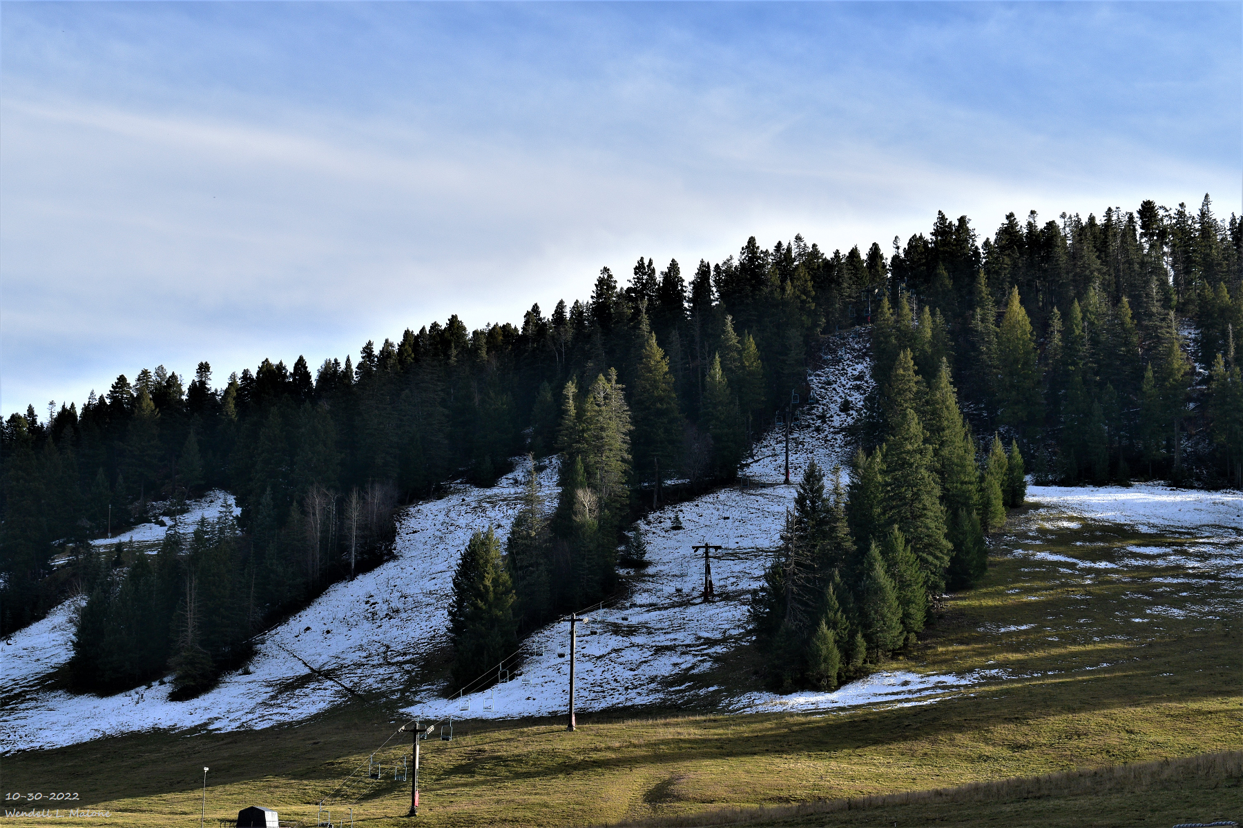
Ski Cloudcroft.
Thanksgiving Ushers In A Major Winter Storm.
(At 11 AM MST Wednesday Morning).

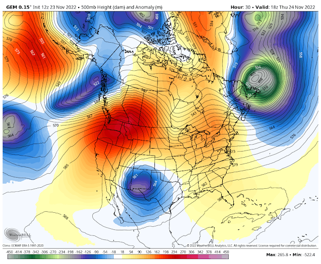
GFS 500 Millibar (18,000') Forecast.
Valid At At 11 AM MST Thanksgiving Morning.
.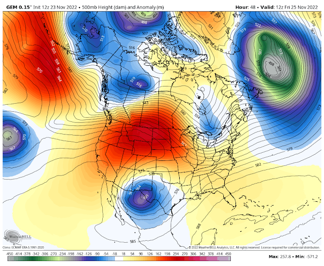

GFS 500 Millibar (18,000') Forecast.
Valid At At 5 AM MST Friday Morning.

Valid At 5 AM MST Thanksgiving Morning.


A strong mid-level short wave was centered over Utah last this Wednesday afternoon. A second and weaker mid-level short wave was located west of central Baja late this afternoon. This second weaker short wave will get pulled up to the northeast and absorbed into the stronger short wave as it continues to dive southward tonight into Thanksgiving.
By around noontime Thanksgiving Day a strong and dynamic closed low is forecast to be located west of El Paso. It will continue digging south into northern Mexico southeast of El Paso into Friday morning. Thereafter it is forecast to lift northeastward east of the Midland/Odessa area by Saturday.
At the surface a strong polar cold front will dive southward through New Mexico and West Texas tonight. By sunrise Thanksgiving morning it will have pushed south of a Tucson-El Paso- Midland/Odessa line.
Rain will quickly mix with then change over to all snow Thanksgiving afternoon first across the northern sections of the Southeastern Plains, and the Sacramento mountains. Snow will increase in intensity, aerial coverage and spread south and west Thanksgiving night into Friday. Some lower locations may see a brief mix of rain and snow before seeing all snow.
Thanksgiving Day.

Friday.

High temperatures on Thanksgiving Day will be tricky depending upon how fast the colder air behind the southward moving cold front settles in over the area. Here in the Southeastern Plains we should only see the mid-upper 40's for highs. Northeastern and eastern New Mexico will only be in the 30's as will the Sacramento mountains. Highs across the local area on Friday will be in the upper 20's and 30's.
Valid Thanksgiving Day Through 5 AM MST Saturday.

NAM 12 K Storm Total Snowfall Forecast.
Valid Thanksgiving Day Through 11 AM MST Saturday.

NAM 3 K Storm Total Snowfall Forecast.
Valid Thanksgiving Day Through 11 PM MST Friday Night.

NCEP WRF Storm Total Snowfall Forecast.
Valid Thanksgiving Day Through 5 PM MST Friday.

SREF Storm Total Snowfall Forecast.
Valid Thanksgiving Day Through 5 PM MST Saturday.

NWS NDFD Storm Total Snowfall Forecast.

Are Historic Snowfall Totals Possible?
After looking through the various computer model forecasts, discussions, and satellite imagery I find that this incoming Major Winter Storm has the same look and feel that the December 27-30, 2015 Blizzard did. Same forecast tracks, similar excessive snowfall forecasts. Question is will this one be as bad as 2015?
Taking a middle of the road approach here is where I stand as far as storm total snowfall totals go across the eastern plains east into the Texas South Plains, the Southeastern Plains, the Capitan, Sacramento, and Guadalupe mountains, and parts of West Texas.
Widespread 6"-10" seems to be the common theme outside of the mountains. Higher storm totals are highly likely across the lower elevations...in excess of 10" possible. With convective banding there may even be a few thundersnow events. How high do we go? In my opinion I don't think it's out of the question to see some locations see totals in the 12" - 18" range.
Honestly the models are excessive with some of their storm total forecasts. Such as the 24" to 31" across the east slopes of the Sacramento mountains out into the Southeastern Plains including the Roswell, Hope, Artesia, and Carlsbad areas. It has happened once before in our recorded history back in 1931. Carlsbad recorded 25.1" on Nov 30th, Dec1, 2nd 1931 with 18" on the ground on Dec 2nd, 1931.
Some of the higher east facing slopes of the Capitan, Sacramento, and Guadalupe mountains certainly could easily see these totals. Ski Apace may even be looking at an event total of 2 to 3 feet. Overall its hard to have a more perfect set up as far as location, strength, moisture, and slow storm movement is concerned.
Winter Storm Watches are now in effect for the Texas South Plains, the eastern Plains of New Mexico, the Capitan, Sacramento, and Guadalupe mountains, the Southeastern Plains including Chaves, Eddy, Lea, and Culberson county in West Texas. Winter Storm Watches also cover parts of West Texas. Generally from Thanksgiving through Saturday morning.
I am concerned that some locations may experience near blizzard or blizzard conditions with this storm. Places like the eastern plains, parts of the Southeastern Plains, the east slopes of the mountains including Guadalupe Pass will have the best chances of seeing these conditions.
Many local roads and highways across the above warned areas including Southeastern New Mexico will become difficult to drive on if not impossible. Life threatening and dangerous driving conditions are expected in many areas. New Mexico and nearby areas have a long history of stranded motorist on area roads during events of this magnitude. If you don't have to travel then please don't or least until its safe to do so. Expect some road closures in the hardest hit locals from the heavy snow, blowing and drifting snow, and icy spots.
Blowing and drifting snow may also severely limit the visibility in many areas due to northerly/northeasterly winds gusting up to 40 mph. These winds are forecast to gust up to 60 mph through Guadalupe Pass. Significant widespread travel disruptions may occur in many areas.
Now is the time to take preventive measures to protect livestock and pets that are outdoors where possible. Livestock, diary cows, and open range animals will be especially venerable to these harsh winter conditions. Since tomorrow is Thanksgiving you might consider stocking up today on whatever food goods, gas, medicines, and other essentials needed to get you by through the upcoming holiday weekend. The storm currently is forecast to end on Saturday but its lingering effects will be felt into at least the first of next week.
There Are None So Blind As Those Who "Will - Not" To See...107.


Comments
Post a Comment
Your comments, questions, and feedback on this post/web page are welcome.