


Slight Warm-Up Today - Winter Weather Friday - Sunday.
Northeast Of Ruidoso, NM.
Near Sierra Blanca Regional Airport.


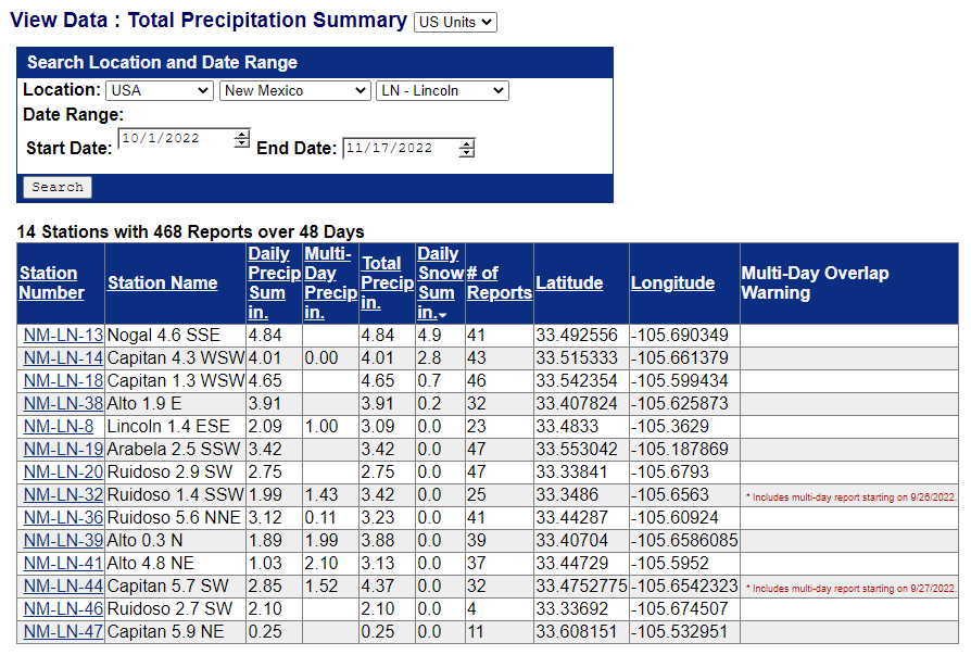
The Cloudcroft NWS Climate Co-Op Station has recorded 6.7" of snowfall thus far this season (October 1st - November 16th).

At 5 AM MST Thursday Morning.
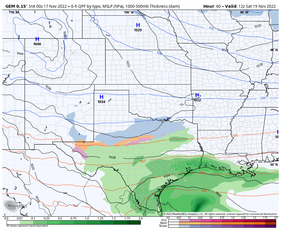
Surface Map Forecast.

(Precipitation Type & MSLP).
Canadian (GEM) 500 MB/18,000' Forecast.


NWS NDFD Apparent Temperature Forecast.

Valid At 6 AM MST Friday Morning.
NWS Forecast Hight Temps Friday.

Canadian (GEM) Forecast Temperature Anomaly.

Valid At 11 AM MST Friday.
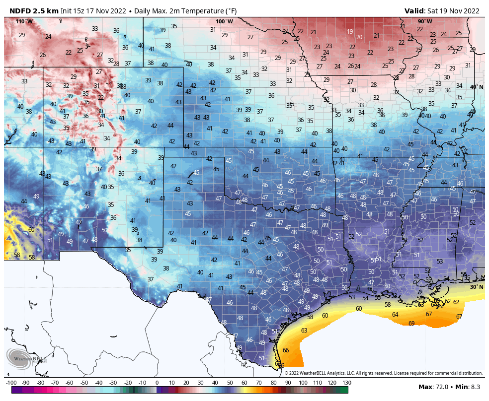
NWS NDFD Forecast High Temps Saturday.
Canadian (GEM) Forecast Low Temps Monday Morning.

(Today).


Valid Today Through 5 PM MST Saturday.
NWS Albuquerque Precipitation Type Forecast.

A modified arctic cold front will backdoor south and west across New Mexico today into Friday morning. Ahead of this front temps will warm up today into the 50's across eastern and Southeastern New Mexico. Then the bottom falls out tonight as the colder air arrives behind the front. Temperatures on Friday will be some 20º to 35º below normal across the eastern one third of the state.
Stiff northeast to easterly winds gusting up to around 15-30 mph along and behind the arctic frontal boundary late tonight into Friday morning will drop apparent temperature values down into the -5ºF to 0ºF range across the northeastern plains, the northern mountains, and the central mountain chain and Middle Rio Grande Valley. Across northwestern, northern, and eastern New Mexico apparent temperature values will drop down into the single digits. Southeastern New Mexico will see apparent temperature values down around 10ºF to the mid teens. And the Sacramento mountains from near 0ºF to the single digits.
Apparent temperature, also known as feels like, is the temperature equivalent perceived by humans, caused by the combined effects of air temperature, relative humidity and wind speed. The measure is most commonly applied to the perceived outdoor temperature.
Apparent temperature, also known as feels like, is the temperature equivalent perceived by humans, caused by the combined effects of air temperature, relative humidity and wind speed. The measure is most commonly applied to the perceived outdoor temperature.
A wintry mix of freezing fog, freezing drizzle, and light snow will spread southward down the northeastern, eastern, and southeastern plains tonight into Friday and Saturday. Friday and Saturday will be cold and dreary with overcast skies and wintry precipitation.
Forecast high temps on Friday range from the low-mid twenties across northeastern New Mexico to the mid 20's across the eastern plains, and the 30's across most of the southeastern plains. Highs over Southeastern New Mexico on Saturday will only be in the 30's.
Highs in the Sacramento mountains will range from the mid 30's to mid 40's today, and the mid to upper 30's Friday. Highs Saturday will be in the upper 20's to the 30's.
Pockets of freezing fog and light freezing drizzle will be possible across the Southeastern Plains and the east slopes of the Sacramento mountains Friday night into Saturday morning. This could pose some localized travel issues on area highways, roads, and bridges. Widespread significant ice accumulations are not anticipated at this time.
Current forecast models indicate that light snow could also fall over parts of the Southeastern Plains and Sacramento mountains Saturday into Sunday. A mid-level shortwave trough of low pressure is forecast to drop into the state Friday night into Sunday. How far south this storm drops and how strong will either aide or prevent snow accumulations especially in the mountains. Current local forecasts call for less than an inch of snowfall except for the northeastern plains where an inch or two may fall. This may change.
There Are None So Blind As Those Who "Will - Not" To See...107.


Comments
Post a Comment
Your comments, questions, and feedback on this post/web page are welcome.