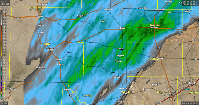
Rain Fell Upon The Plain Overnight - Much More To Come!
Rain Upon The Plain Overnight.
As Of 4:21 AM MDT This Saturday Morning.
Cannon AFB Radar Estimated 24-Hour Rainfall Totals.
As Of 4:22 AM MDT This Saturday Morning.
As Of 5 AM MDT This Saturday Morning.
As Of 5 AM MDT This Saturday Morning.
As Of 5 AM MDT This Saturday Morning.
The totals highlighted in red indicate the 24-hour total. The light blue shaded totals are since midnight last night.
Active Weather Pattern This Weekend Into Next Week.
This morning national map looks more like a winter scene than a fall one out west. Numerous watches and warnings are in effect ranging from Red Flag Warnings to Winter Storm Warnings. Click on the link to the map to open it up then pick a spot you are interested in on the map and click on it. That will take you to the National Weather Service forecasts, watches, warnings, and much more for your area of interest. This map auto populates so its always update with the latest info.
Big Winter Storm Out West - Summer In The South & East.
Valid At Midnight Last Night.
US GFS 500 MB/18,000' Forecasts.
Valid At 6 AM MDT Sunday Morning.
Valid At 6 AM MDT Monday Morning.
Valid At 6 AM MDT Tuesday Morning.
A deep and cold mid-upper level closed low will essentially remained parked over the Pacifc Northwest states today into Monday. This will aide in clobbering parts of northern Montana and southwestern Canada with incredible amounts of heavy wet snow.
Parts Of Montana To Get Buried By Heavy Wet Snow!
Snowfall totals are forecast to range from 15" to 36" across the lower elevations of northwestern Montana with 3 to 5 feet in the mountains which will be blown around by wind gusts of up to 50 mph. That's impressive for anytime in the winter and almost unheard of this early in the fall!
Excerpts from the Great Falls, Montana National Weather Service Office forecaster on duty early this Saturday morning in the Area Forecast Discussion (AFD):
  Snowfall amounts have changed very
  little from previous forecast, as model guidance continues to remain
  in very good agreement with the evolution of the winter storm.
  Because of this, have decided to add Hill, Blaine, Choteau, and
  Fergus Counties to the Winter Storm Warning. While portions of these
  counties (especially eastern portions) will see lighter snowfall
  amounts, the mountains and western portions will likely see
  significant impacts from the heavy, wet snow. Extreme impacts are
  still expected along the Rocky Mountain Front and portions of the
  North Central Montana plains through Sunday night due significant
  accumulations of the heavy, wet snow and strong north to northeast
  surface winds. Widespread tree damage is possible due to the heavy,
  wet snow falling onto trees with foliage. Downed power lines are
  also possible, resulting in widespread power outages that could last
  days in remote areas where access is limited due to the depth of the
  snow. Agricultural interests; outdoor  recreational interests,
  including camping and hunting activities; and travel will also be
  extremely impacted. Blizzard conditions remain possible along the
  Rocky Mountain Front and immediate eastern plains tonight through
  Sunday, but have decided to hold onto the Winter Storm Warnings for
  now given the heavy ,wet nature of the snow, which may not
  blow around enough to reduce visibilities below 1/4 mile. - Moldan
Meanwhile In New Mexico.
Valid Today Through Monday, October 7th, 2019.
GFS 16-Day Temperature & Rainfall Forecasts.
Cooler and much wetter weather remains in our local forecasts this weekend into next week. Our closed low that was parked over the Baja Region has lifted northeastward into northern New Mexico and opened up early this morning as forecast. Enough instability combined with a sharping dryline over the local area, and daytime heating will once again help to kick off scattered thunderstorms this afternoon and evening and again on Sunday.
A few of these thunderstorms may become severe and produce large hail, damaging thunderstorm wind gusts in excess of 60 mph, deadly cloud to ground lightning, locally heavy rainfall along with localized flash flooding.
Heavy Rains - Flash Flooding Concerns Next Week.
Heavy rains and flash flooding will be a concern Monday into the at least the middle of next week over the area. As the powerful winter-like storm over the Pacific Northwest digs a little further south early next week the flow aloft over New Mexico and the surrounding areas will remain southwesterly. Subtropical moisture is forecast by the models to get pulled northeastward into the Desert Southwest including New Mexico by this southwesterly flow aloft.
Training thunderstorms or thunderstorms that repeatedly move over a location will elevate the threat for flash flooding as will several days in a row with heavy rainfall. Of course the GFS model currently is the most aggressive with its storm total forecasts locally of 3" to 5" of rainfall fairly widespread over the local area next week. Notice too that our temperatures will cool off over the next week to ten days.
The Truth Is Stranger Than Fiction - And Sometimes It Hurts!


Comments
Post a Comment
Your comments, questions, and feedback on this post/web page are welcome.