Why Are My Weather Posts Missing From Facebook.

Hello everyone. I just wanted to let you know that my Facebook page was shut down without any warning by Facebook this past Saturday, June 8th. All I was told was that I had violated their community standards. I don't know what triggered that; they didn't tell me. I was told this may be permanent or for six months.
My guess is that it may be because I posted several comments and articles from my Substack page about the riots in LA, and that must have triggered/angered someone, and they complained, thus Facebook shut me down. I don't know this as fact, though. I have appealed this decision, and I'm still waiting for their reply. I have read on X that this has happened to other Facebook users posting about the LA riots as well.
I always share my weather blog posts (that I post here) on my Facebook page and my X page. This included over twelve different New Mexico and West Texas Facebook Community sites. So there are thousands of you out there (based on my views and shares of those posts) who will no longer see those posts. My Facebook page may or may not be restored.
This is another good reason (as the National Weather Service often reminds us) to have multiple ways of receiving severe weather alerts when severe weather threatens your location. My weather web page is one of those ways, and I really appreciate all of you who have and still do use it. Thank you so much!!!
If my Facebook page is restored, I will continue to share my weather blog posts and some of the NWS Watches and Warnings...as I have been doing for years now.

Goodbye Rain - Hello Heat.


Today.


Monday.


Tuesday.


Wednesday.


Thursday.


Friday.


For now our stormy weather comes to an end. We are leaving the average heart of our severe weather season as we head towards the end of this month. Does this mean that we can't have severe thunderstorms from here on out? Absolutely not. Severe thunderstorms have been documented just about every month of the year locally. We usually have a second severe weather season beginning around the end of August into the first of October. Without a doubt our spring was very active severe weather-wise and got off to an early start.

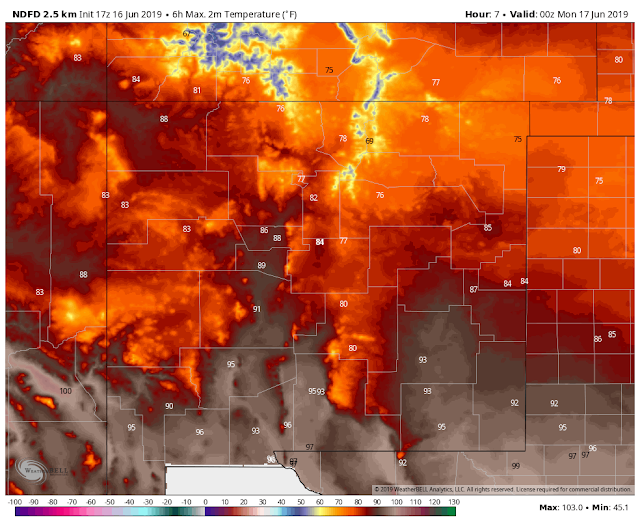
The heat machine is slated to crank up over the area over at least the next week if not beyond. Forecast high temperatures over the next week to ten days will be at or above 100ºF. Next Friday looks to be the hottest day of the upcoming week with a forecast high temperatures in Carlsbad of 104ºF. Don't be too surprised if we don't end up getting hotter than this. 

June typically sees the highest temperatures recorded locally. July, August, and September can be comparably miserable for us in some years because of the increased rainfall and humidity. Long range models aren't offering much hope for relief from the heat as far as rain is concerned either.


(Years With High Temps 108ºF Or Above).

Roswell Airport.


Artesia Climate.


Carlsbad Climate.


Carlsbad Airport.


Hobbs Climate.


The Truth Is Stranger Than Fiction - And Sometimes It Hurts!

Comments

NWS Albuquerque Burn Scar Matrix

Current National Weather Service Watches/Warnings In Effect.

New Mexico

Chaves County Plains & Mtn's

Eddy County

Culberson County

Lea County

Lincoln County

Otero County

Current US Temps

Current US Wind Chill/Heat Index Temperatures

WPC 7-Day Precipitation Forecast

Roswell Live EarthCam

Ruidoso Live Webcam

Cloudcroft Live Webcam

NWS Midland 3-Day Precipitation Forecast

NWS Midland 3-Precipitation Chances

New Mexico 3-Day Precipitation Forecast

New Mexico Precipitation Chances

NWS El Paso 3-Day Precipitation Forecast

NWS El Paso Precipitation Chances

US 24-Hour Precipitation Forecast

US 3-Day Precipitation Forecast