Springlike Wind & Dust Storm Saturday.
Last Nights NAM 06Z 500 MB Analysis.
NAM 500 MB At 5 PM MST Today.
NAM 500 MB At 5 PM MST Saturday.
What goes up, will in time, eventually come back down. This is going to be true concerning our springlike temperatures that we have been experiencing recently. Early this morning our next winter storm to affect the area was located over northern California. It is forecast to move eastward across northern Arizona tonight, then northeastward into northern Colorado by sunset Saturday.
Saturday is going to be a windy and dusty day across southern and southeastern New Mexico, as well as across parts of west Texas. With our next inbound winter storm tracking well to our north, we get the drier backside of the storm, which means lots of wind and dust.
Southwesterly winds are forecast to increase to around 25 - 35 mph with gusts near 50 mph across the southeastern plains by around midday Saturday. I wouldn't be surprised to see some higher gusts either.
Across the Guadalupe mountains southwesterly winds are forecast to increase to sustained speeds of 40 -55 mph with gusts up to around 85 mph. Dangerous driving conditions will be prevalent in these high winds, especially for high profile vehicles. Westerly winds are forecast to gust to around 65 mph across the northern Sacramento mountains, and 55 mph across the southern Sacramento mountains.
Areas of blowing dust are likely to develop by around noontime, some of which may become fairly widespread. Localized areas of blowing dust may suddenly without any advanced warning drop the visibility down to zero. This will be true over and near freshly plowed or exposed farmlands, fields, lots, and construction sites. Travel on north and south facing highways may become dangerous in some areas due to the high cross wind gusts and localized areas of blowing dust.
Critically Dangerous Fire Weather Conditions will also exists across of the local area. Please refrain from any type of outdoor activity that involves the use of sparks or flames. Any wildfire that may accidentally be started will have the ability to rapidly spread and grow in the high winds.
A few scattered thunderstorms may fire up across far eastern sections of west Texas Saturday night as the Pacific cold front and dryline pushes east into that area. Some of these thunderstorms may be severe in the strongly sheared environment.
Saturday will be a warm day with highs ranging from the low 70's in the Roswell and Artesia areas, to the mid-upper 70's in the Carlsbad area. A Pacific cold front will sweep eastward across the state on Saturday with colder temperatures following its passage Sunday into Tuesday.
GFS 500 MB Forecast At 5 PM MST Monday.
GFS 500 MB Forecast At 5 AM MST Tuesday.
Winter storm #2 rolls into New Mexico on Monday and will bring colder temps along with more widespread snow to the state at least into Tuesday.
GFS Sow Depth Forecast At 5 PM MST Tuesday.
ECMWF Total Snowfall Forecast At 5 PM MST Tuesday.
GFS Temp Anomaly Forecast At 5 PM MST Tuesday.
Albuquerque, NM.
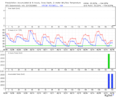
Roswell, NM.
Carlsbad, NM.
Ruidoso, NM.
Not too surprising the models are already struggling with our next winter storm due to impact the state Monday into Tuesday. I'm not so sure that I buy the trend of last nights model runs tracking this storm further to the north.
Last nights 00Z/5 PM MST run of the GFS model was forecasting more of a trough of low pressure moving across northern New Mexico and into the Texas Panhandle by Tuesday evening. The 06Z/11 PM MST GFS run has a closed low located over eastern New Mexico by sunrise Tuesday morning. This makes more sense to me, and agrees more with the previous runs over the last several days.
The Truth Is Stranger Than Fiction!
My Web Page Is Best Viewed With Google Chrome.


Comments
Post a Comment
Your comments, questions, and feedback on this post/web page are welcome.