Severe T-Storms Tonight - High Winds Monday.
May 4th, 2019.
Diane J. Malone.
Valid At Noon MDT Monday.
GFS 500 MB/18,000' MSL Forecast.
Valid At Noon MDT Monday.
Valid At 6 PM MDT Monday.
May has been rather active this year which isn't all that unusual. The jet stream continues to dive southward and southeastward out of the Pacific Northwest...sending one closed low after another into the region. Such is the case again Monday.
Severe Thunderstorms After Midnight Tonight.
Valid Today Through 7 AM MDT Monday Morning.
Severe Thunderstorms Possible Tonight Into Monday Morning.
Forecast models indicate that a 120 knot or 138 mph jet stream maximum will be approaching New Mexico from the west tonight. Low level Gulf of Mexico moisture will back into portions of northeastern, eastern, and southeastern New Mexico tonight behind a backing dryline. As the atmosphere over and near the NM/TX State line destabilizes, and low level moisture increases tonight, a few scattered severe thunderstorms are expected to develop.
These severe thunderstorms (some supercells possible) will occur mostly likely from around midnight tonight into Monday morning. The further that the dryline is able to back westward into the eastern one third of New Mexico tonight the better the chances for these thunderstorms to develop. Large hail, damaging thunderstorm wind gusts, and a few isolated tornadoes will be possible. Severe thunderstorms that develop at night are not unheard of in New Mexico so be situationaly aware of our weather tonight and be prepared for the possibility of severe weather especially for those of you who live close to the state line.
A more widespread significant severe weather outbreak appears likely Monday into Monday night from West Texas northeastward into Nebraska. Very large hail, damaging thunderstorm wind gusts, and significant tornadoes will be possible especially in the Moderate Risk Area.
High Winds Will Rake Our Area Monday.
Valid Monday - Tuesday.
A Pacific cold will enter the local area late Monday afternoon and evening. The dryline is forecast to rapidly mix eastward before noontime on Monday which will shift the severe weather threat further to our east. Another widespread significant severe weather event appears to be shaping up across much of West Texas northeastward into Oklahoma Monday night.
Strong southwesterly to westerly winds are forecast to rake the local area Monday. High Wind Watches have been issued for southwest winds forecast to gust up to 65 mph across the southeastern plains, and 80 mph in the Guadalupe mountains.
Southwesterly winds are forecast to gust up to around 55 to 60 mph across Chaves, Lincoln, and Otero Counties.
Localized areas of blowing dust will likely occur. Dust prone areas such as freshly plowed or exposed farmlands, fields, open lots, and construction sites may suddenly experience drops in the visibility down to near zero with little to no advanced warning.
Valid At 6 AM MDT Wednesday.
Valid At 6 AM MDT Wednesday.
Valid At 6 AM MDT Wednesday.
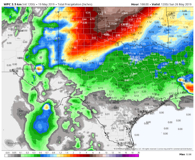
WPC Storm 7-Day Total Rainfall Forecasts.
Valid Today Through 6 AM MDT Sunday, May 26th, 2019.
Valid Today Through 6 AM MDT Sunday, May 26th, 2019.
Given the current upper air pattern it appears that most of the local area will remain high and dry as far as rainfall goes through Wednesday. Not so across West Texas northeastward into Oklahoma. A few areas of northwestern and northern New Mexico may end up with some decent rainfall totals from this storm also.
Oklahoma and Kansas are forecast to get clobbered by the rain over the next week. This mornings WPC 7-Day Rainfall Forecast calls for 8" to 10" totals across south-central Kansas by next Sunday.
Valid At 6 AM MDT Wednesday.
Valid At 6 AM MDT Wednesday.
Heavy snowfall is once again forecast for the mountains of Colorado and northern New Mexico. Winter just refuses to give up in these areas.
The Truth Is Stranger Than Fiction - And Sometimes It Hurts!


Comments
Post a Comment
Your comments, questions, and feedback on this post/web page are welcome.