

Hope For Rain In SE NM - Heavy Rains Continue In The Sac's - First Look At Winter.

August 6, 2022.
A Cool Morning In The Sacramento Mountains.My family went camping in the Sacramento mountains this past weekend and what a cool refreshing experience that was to get out of the oven heat of the Southeastern Plains. Waking up to low temps in the 50's with highs in the low 80's was a treat for sure.


Low temperatures in the Pecos Valley and the rest of the Southeastern Plains of New Mexico have been running a little above normal for a good part of the summer. The Carlsbad Airport ASOS has reported a morning low temp of 70º or higher every day of this month so far. This is also true for the Artesia and Roswell Airports. Even the Sacramento mountains have been coming in a little warmer than normal in spite of the clouds and rain.
Normal High/Low Temps For August 9th.
Roswell 96/70
Artesia 95/65
Carlsbad 96/70
Hobbs 94/69
Elk 84/55
Elk 84/55
Picacho 89/61
Mtn Park 80/56
Ruidoso 80/49
Cloudcroft 69/48
As daylight slowly fades day by day as we come to the close of the meteorological summer so will our daily high temps...overall. No, we are not done with the torrid heat but climatologically this is the time of the year when our daily high/low temps gradually on average start coming down. And like most of you, I am ready for the fall which begins September 1st as far as the meteorological beginning of fall is concerned. Although not our hottest summer on record it has been rough.
Southeastern Plains.

Southern New Mexico.

Meanwhile, the Southeastern Plains continue to bake in the La Nina summer heat. Roswell is two days away from tying the record with the number of days with high temps of 100º or higher (June-August). In 2011 they recorded 56 days...as of yesterday, they had recorded 54 days.
In 2011 the Artesia Climate Co-Op Station recorded 63 days with high temps of 100º or above. In 2011 the Carlsbad Climate Co-Op Station recorded 58 days and 64 days in 1943 that were 100º or above. In 2011 the Carlsbad Airport recorded 70 days with high temps of 100º or higher.
It is odd that the Roswell Airport has recorded 20 more days than the Carlsbad Airport with daily highs of 100º or higher. Normally its the other way around.
It is odd that the Roswell Airport has recorded 20 more days than the Carlsbad Airport with daily highs of 100º or higher. Normally its the other way around.
2022 Year-To-Date Rainfall Totals.
(January 1st - August 9th, 2022).
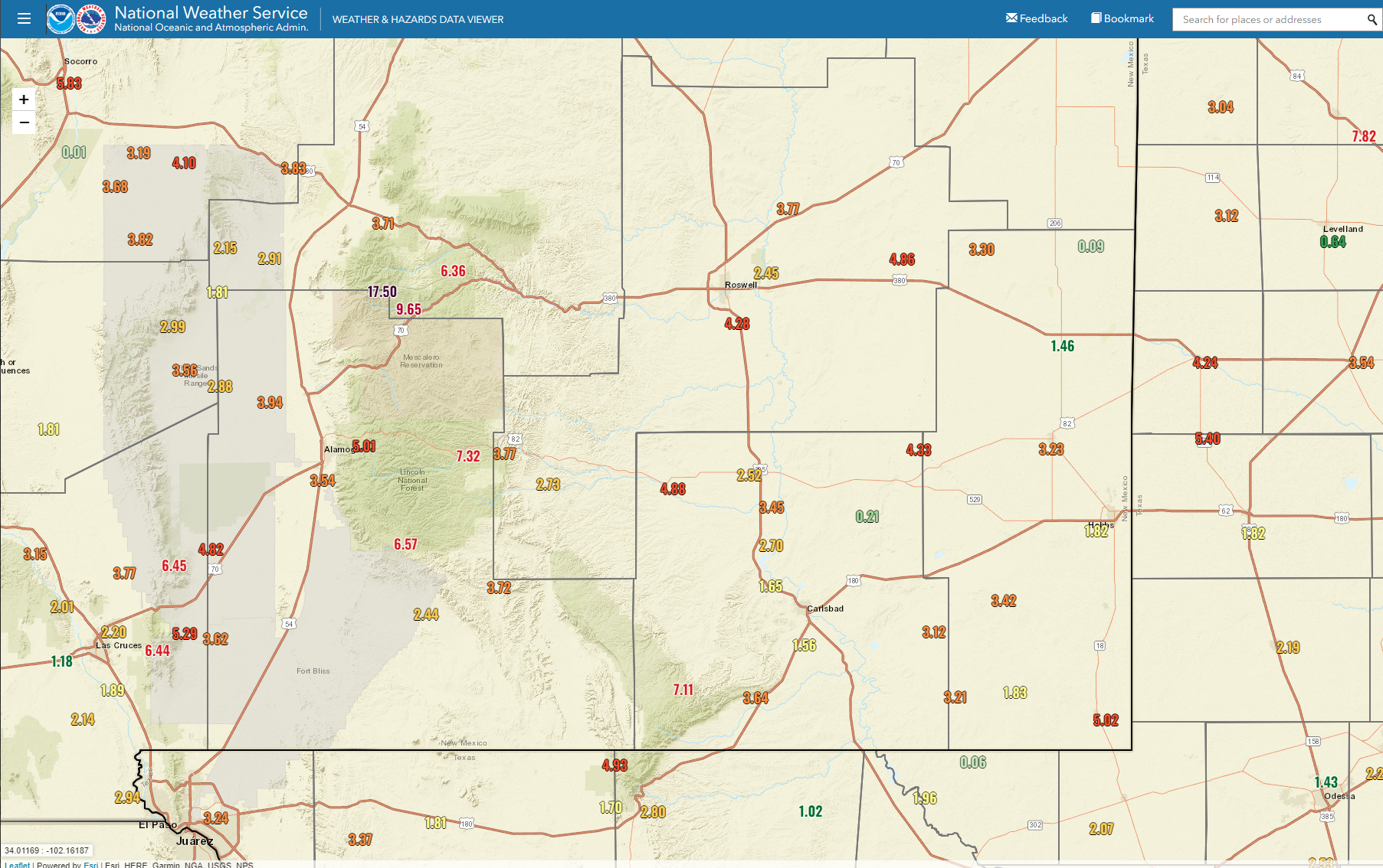


Central & Sacramento Mountains.


Some Hope For Rain Over The Next Week.
As Of Noon MDT Tuesday.

As Of Noon MDT Tuesday.


Some parts of northern Roswell were lucky enough to pick up as much as a quarter of an inch to a third of an inch of rainfall last night. And some parts of the Sac's have had rainfall over the past 24 hours, especially along the western slopes of the mountains.
Thunderstorms are already becoming numerous over the Sac's as of noon today (Tuesday).
In fact, as of 1:50 PM MDT Personal Weather Stations (PWS) in the Cloudcroft area are exceeding an inch of rainfall. The Daltons Mountain PWS in Cloudcroft is reporting 1.70".
Thunderstorms are also dumping rain in the Ruidoso and Ski Apache areas. The Little Creek PWS in Alto is reporting 1.97" of rain as of 1:55 PM MDT.
As our not-so-favorite mid-level ridge of high pressure continues to dominate our local weather it will continue its pattern of wobbling around as has been the case all summer. A weakness in the ridge over the next several days will continue to aid in the northward transport of monsoonal moisture over the state.
A weak cold front aided by outflow boundaries from thunderstorm activity will help focus an increase in scattered thunderstorms across the Southeastern Plains today into Friday. Our chances for rainfall across the Pecos Valley jump up into the 30% to 50% range this afternoon into Thursday night. Locally heavy rainfall (1" to 3") will be possible in a few locations along with localized flash flooding. The flash flood threat is much higher over the Sacramento and Capitan mountains, especially over and downstream of the burn scar areas today into Friday.
A weak cold front aided by outflow boundaries from thunderstorm activity will help focus an increase in scattered thunderstorms across the Southeastern Plains today into Friday. Our chances for rainfall across the Pecos Valley jump up into the 30% to 50% range this afternoon into Thursday night. Locally heavy rainfall (1" to 3") will be possible in a few locations along with localized flash flooding. The flash flood threat is much higher over the Sacramento and Capitan mountains, especially over and downstream of the burn scar areas today into Friday.
Burn Scar Forecast Flash Flood Threats.

What About Our 2022-2023 Winter Outlook?

One of my favorite rules concerning weather/climate is "what goes up - always comes down." But when and where? La Nina summers are typically hot and dry such as what we have experienced this summer. La Nina winters typically are warm and dry. But not always. Sometimes they are very cold and in places can be wet/snowy.
There Are None So Blind As Those Who "Will - Not" To See...107.


Comments
Post a Comment
Your comments, questions, and feedback on this post/web page are welcome.