


First Dryline T-Storms Possible Tuesday - Strong Winds Wednesday & Another High Wind Event Friday.

Tumbleweed Runnion.
Hwy 206 South Of Tatum, New Mexico.

At 6 AM MDT This Monday Morning.
Surface Map Forecast.


Seasons First Dryline Thunderstorms Possible Tuesday.
Early this morning a weak cold front sagged south into the area. In spite of this our afternoon temperatures today will be close to normal with this afternoon's high temperatures generally in the low-mid 80's across the Southeastern Plains and West Texas.
Low-level southeasterly flow is forecast to develop over Southeastern New Mexico and West Texas tonight borne upon a 50 knot/58 mph low-level jet. This will advent Gulf of Mexico moisture northwestward into the area...setting up the season's first possible dryline event Tuesday afternoon and evening. Low clouds may develop across parts of the Permian Basin and Southeastern New Mexico late tonight into Tuesday morning.
Low-level southeasterly flow is forecast to develop over Southeastern New Mexico and West Texas tonight borne upon a 50 knot/58 mph low-level jet. This will advent Gulf of Mexico moisture northwestward into the area...setting up the season's first possible dryline event Tuesday afternoon and evening. Low clouds may develop across parts of the Permian Basin and Southeastern New Mexico late tonight into Tuesday morning.
The dryline is a surface boundary that separates a dry to very dry stable airmass on the western side of it from a moist and unstable airmass east of it.
A few isolated thunderstorms will also be possible across the Sacramento Mountains on Tuesday. Don't expect drought-busting rains from them or for them to help relieve the extreme fire danger. In fact, they may be dry thunderstorms that produce more lightning than rainfall.
A High Wind Warning is in effect for the Guadalupe Mountains of Southeastern New Mexico and West Texas for today. East winds sustained at around 35 t0 45 mph with gusts near 60 mph are forecast.
A High Wind Warning is in effect for the Guadalupe Mountains of Southeastern New Mexico and West Texas for today. East winds sustained at around 35 t0 45 mph with gusts near 60 mph are forecast.
Zonal flow aloft (winds aloft moving west to east) will combine with warm afternoon temperatures reaching up into the low-mid 90's, steep mid-level lapse rates, and deep shear to set the stage for a few isolated Supercell thunderstorms across Eastern and Southeastern New Mexico and parts of West Texas.
These thunderstorms will be very isolated in nature so most locations will not see rainfall and those that do will be the lucky few with totals generally on the light side. Although any isolated Supercell thunderstorm will be capable of producing locally heavy rainfall.
As of now (Monday morning) the primary severe weather threats appear to be hail, some possibly large (one inch in diameter or larger), and damaging thunderstorm wind gusts in excess of 60 mph. Along with frequent deadly cloud to ground lightning.
The best chances for these thunderstorms to occur will be late Tuesday afternoon into the evening.
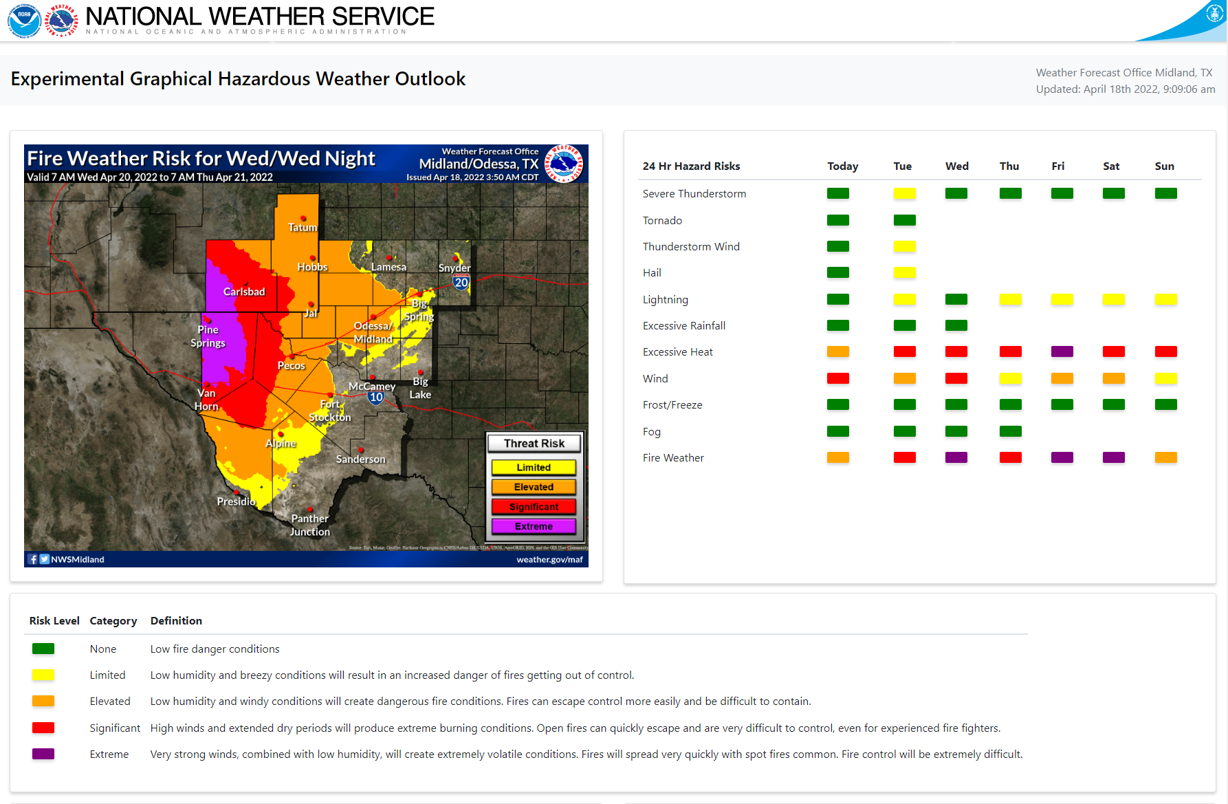
High Winds & Extreme Fire Weather Threats Wednesday.

As the flow aloft tightens and becomes stronger on Wednesday strong westerly winds are once again forecast to rake the local area. Westerly winds sustained at around 35-50 mph across the Guadalupe Mountains with gusts near 65 mph. Therefore a High Wind Watch is already in effect.
Westerly winds will also be strong and gusty across the Sacramento and Capitan Mountains with the strongest gusts reaching up into the 40-50 mph range Wednesday. Across the Southeastern Plains, we can expect to see westerly winds gusting up to around 25-35 mph Tuesday afternoon and 30-40 mph on Wednesday.
Westerly winds will also be strong and gusty across the Sacramento and Capitan Mountains with the strongest gusts reaching up into the 40-50 mph range Wednesday. Across the Southeastern Plains, we can expect to see westerly winds gusting up to around 25-35 mph Tuesday afternoon and 30-40 mph on Wednesday.
Red Flag Warnings are currently in effect for parts of the area today and will likely continue through the rest of the week for many areas of the state. Fire Weather Watches are in effect for parts of the state and local area for Wednesday.
Localized areas of blowing dust will be possible with any isolated thunderstorm Tuesday afternoon and evening. Localized areas of blowing dust will be possible with the strongest winds gusts Wednesday afternoon and evening.
Yet another significant widespread High Wind/Blowing Dust and Extremely Critically Dangerous Fire Weather Event looks to be shaping up for this coming Friday. More on that later this week.
Overall this week will bring pretty typical spring weather to the area. Our first severe thunderstorms of the season generally fire along and east of the dryline in beginning in April.
Today.

Tuesday.

Wednesday.

Thursday.

Friday.

The Truth Is Stranger Than Fiction!


Comments
Post a Comment
Your comments, questions, and feedback on this post/web page are welcome.