Coming Cold & Snow In The US.
Foothills Shrouded In The Fog At Runyan Ranches 11-5-2016.
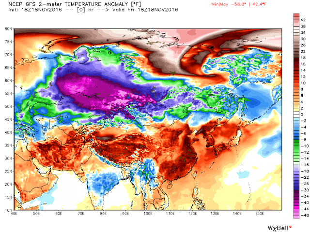
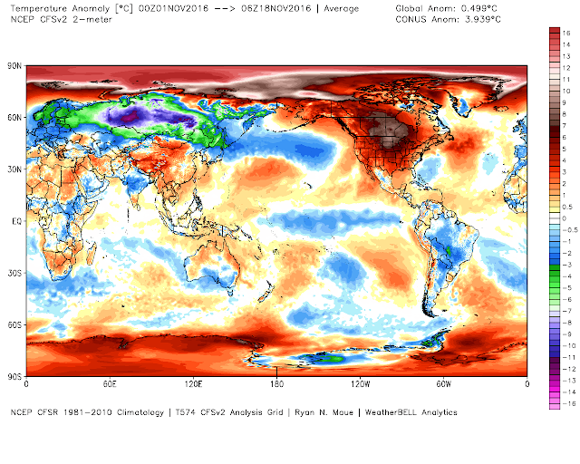
Brutal early cold continues its grip on Russia and Siberia. At 11 AM MST today temperatures were as low as -54ºF in Russia which is some 59-degrees below normal for this time of the year. This has been the theme for the Continent for November so far.
So far 148 new daily record low temperatures have been tied or broken in Russia this month.
A massive and strong dome of high pressure currently residues at the surface over the Northern Asian Continent...to the tune of 1060 millibars or 31.10" of mercury. The European model forecasts this dome of high pressure to strengthen to 1066 millibars or 31.48" of mercury by Saturday. Cold air at the surface trapped with this stable airmass, along with widespread and deep early snow cover, are responsible for the extreme early record setting cold.
Remember last month when I was talking about the age old rule of thumb that says "what goes up - comes down eventually?" Although October and November have been warm and tranquil so far this appears to be about to change. The first blizzard of the season is roaring through parts of the Northern US today and this is a sign of what appears to be coming down the pipe in the weeks ahead. There are hints that what is happening in Northern Asia now could very well be occurring in the US in December. Just how cold and how much snow is up in the air still.
Looking at long range indicators and forecasts it appears that a turn to much colder and snowier weather is going to occur in the US from the end of this month into at least December if not beyond. To tell you the truth I am not a fan of long range forecasting. There are simply way too many variables that are at play for my comfort zone so I usually try and steer away from attempting it.
I am intrigued though by the current setup in the northern hemisphere with the Pacific transiting towards a weak La Nina combined with a continued very quiet Solar Minimum. Different forecasters are using different analog years to try and forecast this upcoming winter. Good luck with those forecasts...they are braver than I am. However if current trends continue then I think we could be in for some very cold temperatures this winter in New Mexico and nearby areas. The winter of 1961-1962, and 1983-1984 come to mind and others.
I am intrigued though by the current setup in the northern hemisphere with the Pacific transiting towards a weak La Nina combined with a continued very quiet Solar Minimum. Different forecasters are using different analog years to try and forecast this upcoming winter. Good luck with those forecasts...they are braver than I am. However if current trends continue then I think we could be in for some very cold temperatures this winter in New Mexico and nearby areas. The winter of 1961-1962, and 1983-1984 come to mind and others.
My point is this...enjoy the relative warmth and calm now because changes are coming.
The Truth Is Stranger Than Fiction!


Comments
Post a Comment
Your comments, questions, and feedback on this post/web page are welcome.