

North Central & South Central NM Get Decent Rains.

(As Of 6 AM MDT March 12th, 2018).

(As Of 6 AM MDT March 12th, 2018).
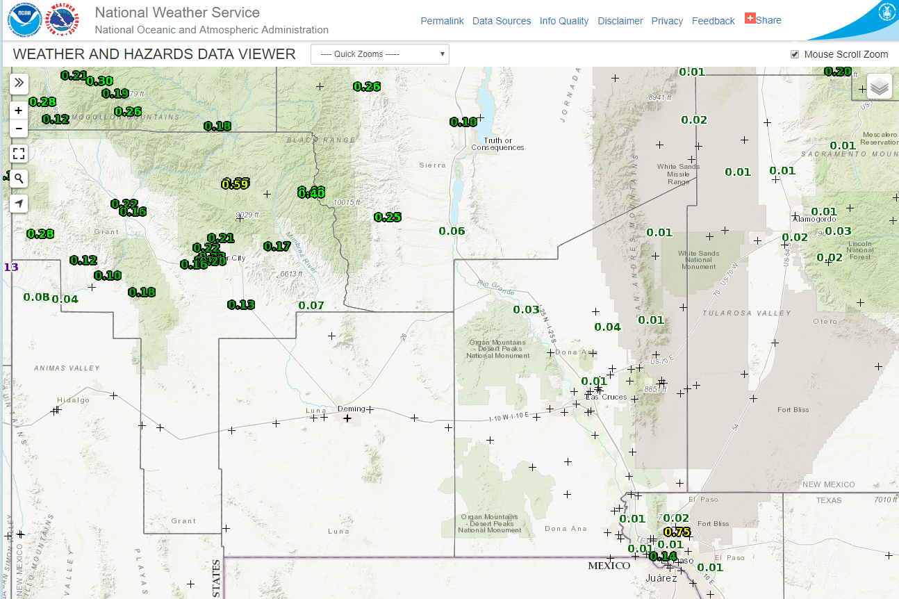
Month - To - Date Rainfall Totals.

(As Of 5 AM MST March 1st - 6 AM MDT March 12th, 2018).

(As Of 5 AM MST March 1st - 6 AM MDT March 12th, 2018).
Year - To - Date Rainfall Totals.

(As Of 5 AM MST January 1st - 6 AM MDT March 12th, 2018).

(As Of 5 AM MST January 1st - 6 AM MDT March 12th, 2018).

(As Of 5 AM MDT September 30th, 2017 - 5 AM MDT March 12th, 2018).

(Winter 2017 -2018).

(Winter 2017 -2018).
(As Of 8 AM MDT This Morning).


(Last Updated At 10:16 AM MDT March 12th, 2018).
• 2 ENE RIO RANCHO - 0.75 in.
• 8 NNW OMEGA - 0.48 in.
• 7 NW ZUNI PUEBLO - 0.45 in.
• 3 WNW GALLUP - 0.43 in.
• 7 SSW MAGDALENA - 0.35 in.
• 5 E EL MORRO - 0.33 in.
• 3 W RIO RANCHO - 0.32 in.
• 4 E GALLUP - 0.30 in.
• 2 SW RIO RANCHO - 0.30 in.
• 2 ESE RIO RANCHO - 0.29 in.
• 1 N CANONES - 0.29 in.
• 1 ENE RIO RANCHO - 0.27 in.
• 2 N CORRALES - 0.27 in.
• 1 ENE CORRALES - 0.27 in.
• 1 SSE GALLUP - 0.27 in.
• 1 SSW SAN ANTONIO - 0.27 in.
• 2 WSW RIO RANCHO - 0.25 in.
• 10 SSE SOCORRO - 0.25 in.
• 3 E GALLUP - 0.25 in.
• 3 WNW BERNALILLO - 0.25 in.
• 1 SSW CHAMIZAL - 0.23 in.
• 8 NW ALBUQUERQUE - 0.23 in.
• 9 NW ALBUQUERQUE - 0.22 in.
• 5 ENE LOS CERRILLOS - 0.22 in.
• 2 W BERNALILLO - 0.21 in.
• 2 ENE GALLUP - 0.21 in.
• 7 N ALBUQUERQUE - 0.21 in.
• 8 NW ALBUQUERQUE - 0.21 in.
• null SAN FIDEL - 0.20 in.
• null BEAVERHEAD - 0.20 in.
• 14 SSE PINE HILL - 0.19 in.
• 2 WSW EL MORRO - 0.19 in.
• 8 NW ALBUQUERQUE - 0.19 in.
• 2 SW BERNALILLO - 0.18 in.
• 8 NW ALBUQUERQUE - 0.18 in.
• 34 ESE MOGOLLON - 0.17 in.
• 3 NNE LOS CERRILLOS - 0.17 in.
• 2 W DATIL - 0.17 in.
• 8 ENE ALBUQUERQUE - 0.16 in.
• 5 NE ALBUQUERQUE - 0.16 in.
• 3 S FARMINGTON - 0.16 in.
• 3 W ALBUQUERQUE - 0.15 in.
• 5 NE ALBUQUERQUE - 0.15 in.
• 1 E SOCORRO - 0.15 in.
• 6 NW ALBUQUERQUE - 0.15 in.
• null PIETOWN - 0.15 in.
• 4 NW ALBUQUERQUE - 0.15 in.
• 5 E ALBUQUERQUE - 0.14 in.
• 2 S GRANTS - 0.14 in.
• 5 WSW ALBUQUERQUE - 0.14 in.
• 2 W EL MORRO - 0.13 in.
• 3 NE ABO - 0.13 in.
• 2 WSW SUNSET - 0.13 in.
• 9 NE ALBUQUERQUE - 0.13 in.
• 2 SSE ALBUQUERQUE - 0.13 in.
• 5 E ALBUQUERQUE - 0.13 in.
• 2 E ALBUQUERQUE - 0.13 in.
• 3 WNW ALBUQUERQUE - 0.13 in.
• 2 SE ALBUQUERQUE - 0.13 in.
• 3 NE FARMINGTON - 0.12 in.
• 6 ENE ALBUQUERQUE - 0.12 in.
• 1 ENE LUNA - 0.12 in.
• 2 E ALBUQUERQUE - 0.12 in.
• 9 NE ALBUQUERQUE - 0.12 in.
• 1 WNW RESERVE - 0.11 in.
• 4 SE ALBUQUERQUE - 0.11 in.
• 8 ENE ALBUQUERQUE - 0.11 in.
• 7 WNW CANONCITO - 0.11 in.
• 8 W SANDIA PARK - 0.11 in.
• 5 S STANLEY - 0.11 in.
• 3 SE ALBUQUERQUE - 0.11 in.
• 7 E ALBUQUERQUE - 0.11 in.
• 1 N SOCORRO - 0.11 in.
• 5 E ALBUQUERQUE - 0.10 in.
• null RIO COMMUNITIES - 0.10 in.
• 3 SSE ALBUQUERQUE - 0.10 in.
• 17 WNW OSCURO - 0.10 in.
• 2 ESE CORRALES - 0.10 in.
• 6 SE SANTA FE - 0.10 in.
• 7 SW ALBUQUERQUE - 0.10 in.
• 8 SW ALBUQUERQUE - 0.10 in.
• 2 ESE BELEN - 0.10 in.
• 1 WNW RESERVE - 0.10 in.
A few light rain showers doted the landscape on Sunday mainly over the Sacramento Mountains to the west of the Pecos Valley. The public reported a light snow shower in Queen at 11:25 AM MST. The CoCoRaHS Station located 3.5 miles north-northeast of Artesia reported .06". The CoCoRaHS Station located 2.5 miles south-southwest of Arabela reported .13". Ski Apache west of Ruidoso with a base elevation of 9,600' reported 2.5" of new snowfall bringing their seasonal total to 40.5".
(March 12th).

The Truth Is Stranger Than Fiction!


Comments
Post a Comment
Your comments, questions, and feedback on this post/web page are welcome.