Rain On The Plains - Snow In The Mountains? - And Severe T-Storms?
Sunset Peak On The Left.
Capitan Peak On The Right.
Looking Southwest From Northeast Of Roswell On St Hwy 246.
Here Comes The Rain & Snow.
A southward-moving cold front has moved through most of New Mexico this morning with a cooler airmass in its wake. Low clouds have overspread the eastern one-half of the state in the moist low-level upslope flow behind the cold front.
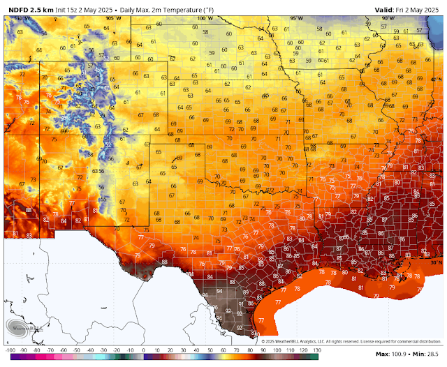
Today's high temps behind the front will be some 10 to 20 degrees cooler than those of yesterday. High temperatures across the state will be some 5 to 15 degrees below normal early next week.
A complicated upper air pattern is developing with a strong and unseasonably cold closed mid-upper level low forecast by the European model to dive out of the Pacific Northwest into southern California by Sunday morning. It is then forecast to slowly wobble around Arizona Sunday into next Monday night. Then centered over the Four Corners area by early Tuesday morning. The low finally opens up and dissipates over New Mexico by next Wednesday. Other models have different forecast tracks and speeds for the evolution of this closed low.
With the slow movement of a strong mid-upper level closed low to our west this weekend into the middle of next week, our forecasts will have a lot of uncertainty in them. Which is not at all unusual with this type of pattern. So expect to see possible changes in your local forecasts this weekend into the middle of next week.
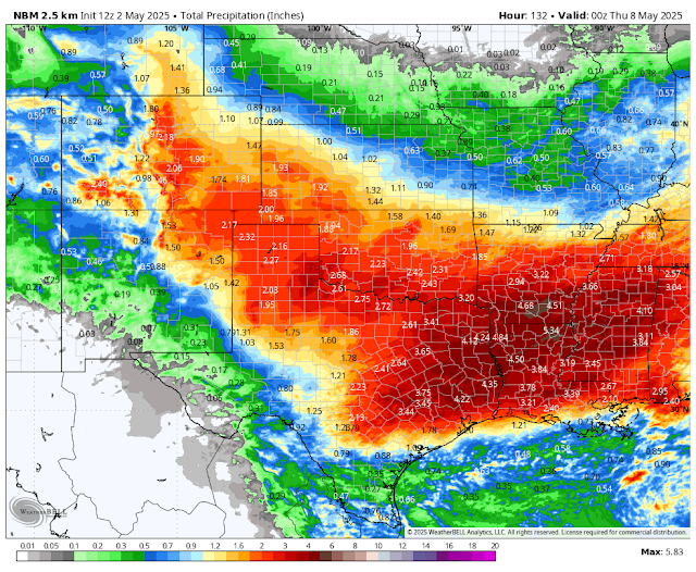
Current model forecasts favor the northern New Mexico mountains, the northeastern plains, the eastern plains, and perhaps parts of the southeastern plains for moderate to heavy rainfall. As of this Friday morning, these areas (except for the southeastern plains) may end up with storm total rainfall amounts of 1" to 3" by next Wednesday.
It is not out of the question that some of these areas may end up getting more rainfall than currently forecast by the models. Localized heavy rainfall, especially from thunderstorms, will pose a flash flood threat over the state's recent burn scars. Heavy rain could also fall across the eastern sections of the state early next week, if severe thunderstorms (supercell thunderstorms part 1 and part 2) develop along the dryline.
Who ends up getting the most rain and or snow out of this storm and when will be highly dependent upon the track and speed of the upper-level storm to our west. A shift further to the south would mean more rain/snow for the western, southern, and southeastern sections of the state. A faster shift further to the north of the current forecast track could mean more rain/snow for the northern and eastern sections of the state, and less for the southern half of the state.
As of today (Friday morning), it appears that the most widespread and heaviest rains will fall Sunday into Wednesday. Severe thunderstorms will be possible across the northern and eastern areas of the state on Sunday, and perhaps again early next week across the eastern one-half of the state.
Believe it or not, but snow showers are possible across the western and northern mountains of the state Monday into Wednesday. Some model forecasts even call for heavy snowfall over the northern mountains. Current snow levels are forecast to be around 7,000' to 8,000' and above. This may change.
Snow showers are also possible Monday into Wednesday across the higher elevations of the Sacramento mountains, including the Sunspot, Cloudcroft, and Ski Apache areas...generally above 8,000'. Maybe even the Mayhill, Sacramento/Weed, High Rolls/Mountain Park, and Ruidoso areas, on Monday night. It's too early to know if there will be any accumulations yet.
I know it's the first of May, but believe it or not, snow has been observed in southeastern New Mexico before in May.
At 8:51 AM MDT, Friday Morning.
Valid From Midnight Last Night Through Midnight Next Wednesday.
Weather Prediction Center (WPC) 7-Day Storm Total Rainfall Forecast.
National Blend Of Models 7-Day Storm Total Rainfall Forecast.
Valid At 6 PM MDT Wednesday, May 7, 2025.
Valid At 6 PM MDT Wednesday, May 7, 2025.
National Blend Of Models 7-Day Storm Total Snowfall Forecast.
Today.
Area Forecast Discussion
National Weather Service Midland/Odessa TX
625 AM CDT Fri May 2 2025

...New AVIATION...

.KEY MESSAGES...
Updated at 625 AM CDT Fri May 2 2025

- A few strong to severe storms will be possible across the
  southeastern Permian Basin, Stockton Plateau, and Lower Trans
  Pecos region late this afternoon into early this evening.

- Low to medium (20-50%) rain/storm chances will continue through
  the weekend mainly along and west of the Pecos River.

- Showers and storms considerably increase in coverage (50-80%)
  by Monday night across areas east of the Pecos River. Strong to
  severe thunderstorms with locally heavy rainfall will be
  possible across far southeast New Mexico, the Permian Basin, and
  into the Trans Pecos region on Monday night.
Area Forecast Discussion...UPDATED
National Weather Service Albuquerque NM
533 AM MDT Fri May 2 2025

...New AVIATION...

.KEY MESSAGES...
Updated at 526 AM MDT Fri May 2 2025

- Higher precipitation chances are expected through mid next week
  with northern and eastern New Mexico favored for heavier
  rainfall amounts. Low forecast confidence exists in
  precipitation amounts for this weekend into early next week.

- Isolated severe storms with large hail and damaging winds will
  impact parts of eastern New Mexico on Sunday.

- Low chance for rapid fire spread across southwest and south
  central areas on Sunday.
Area Forecast Discussion
National Weather Service El Paso TX/Santa Teresa NM
539 AM MDT Fri May 2 2025

...New AVIATION...

.KEY MESSAGES...
Issued at 200 AM MDT Thu May 2 2025

 - Temperatures near to slightly below normal for early May.

 - Moisture pushes into mainly eastern areas this afternoon with
   low to medium thunderstorm chances mainly east of the Rio
   Grande through Sunday.

 - Sunday will be breezy to windy with blowing dust and critical
   fire danger out west.

&&
There Are None So Blind As Those Who "Will - Not" To See...107.


Comments
Post a Comment
Your comments, questions, and feedback on this post/web page are welcome.