

Mayflower & Vilonia, Arkansas Tornadoes 4-27-2014.
Blog Updated @ 12:13 PM MDT.
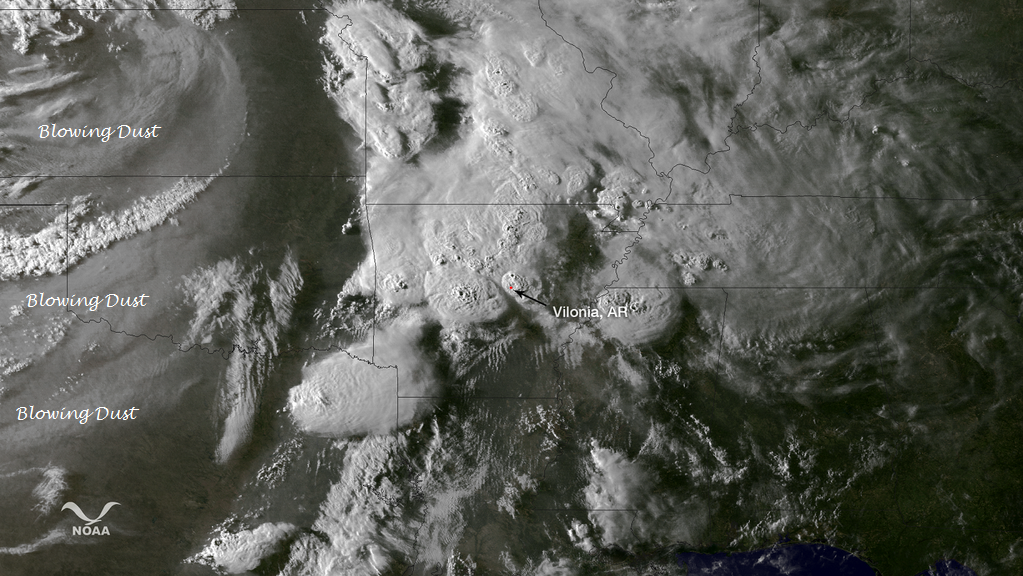
NOAA Satellites @NOAASatellites
GOES image from 2345Z, Apr 27, an hour before tornado reports from Mayflower and Vilonia, Ark. http://go.usa.gov/kv8G pic.twitter.com/z78gXvqaC1
GOES image from 2345Z, Apr 27, an hour before tornado reports from Mayflower and Vilonia, Ark. http://go.usa.gov/kv8G pic.twitter.com/z78gXvqaC1
GRLevel3 2.00 Snapshots.


Several debris balls were noted with these tornadoes on radar as they tore through west-northeast of Little Rock, Arkansas last night. A debris ball occurs when a large tornado picks up a large number of objects on the ground and lofts them into the air.
May 27, 2014 Arkansas Tornadoes.

In the picture: Rotation associated with the parent storm on 04/27/2014 was persistent for roughly 40 miles (Tornado #1) before weakening (where the gap is indicated). Another tornado (Tornado #2) was likely spawned a short time later by the same storm and tracked through White, Jackson, and Independence Counties. Note: Tornado #2 may actually be several tornadoes. This will be determined through damage surveys. The graphic is courtesy of the National Severe Storms Laboratory.


In the pictures: The WSR-88D (Doppler Weather Radar) showed strong rotation between Mayflower and Vilonia (both in Faulkner County) at 738 pm CDT on 04/27/2014. There was also a debris ball present, which is a very good indicator of a tornado causing damage. While this did not turn into an outbreak of severe weather, the ferocity of at least one storm was realized. Just after 700 pm CDT, a supercell (storm with rotating updrafts) rapidly intensified northwest of the Little Rock (Pulaski County) area. A destructive tornado was produced, with the tornado tracking through Mayflower and Vilonia (both in Faulkner County) before apparently dissipating (according to radar) near El Paso (White County). |
Mayflower, Arkansas 4-27-2014.

Three RVs entwined in a metal billboard sign near I-40 in Mayflower.
Courtesy Of Justin Lewis: #KATV #arwx pic.twitter.com/6TzM6y0U9E

Better wide view of tornado damage in Mayflower and what's left of a local business.
Courtesy Of Justin Lewis: #arwx #katv pic.twitter.com/i0KPpuud7Z

Another shot of piled up cars at Mayflower RV from Sunday tornado.
Courtesy Of Justin Lewis: #arwx #KATV pic.twitter.com/DMUYegX6qa

American flag in the storm rubble in Mayflower, AR #tornado #PrayforArkansas @FoxNews @foxandfriends pic.twitter.com/VjFFFKfI4o Courtesy Of Maria Molina.

Vilonia, AR: RT @ChadSDay: Von Lee and his family road out the storm in their cellars.
They came out to this. pic.twitter.com/H8okzO3VVD

New pics from #Vilonia courtesy of @hogwild72023 after #tornado #arwx

pic.twitter.com/MbZFE5Ol2w pic.twitter.com/9vPGn5ncfh
 Vilonia @THV11 pic.twitter.com/bUiPtnnSLN
Courtesy Of Kevin Trager.

 Vilonia, AR.
 @hawgfan1982: @KATV_Weather I-40 in the median near mayflower
pic.twitter.com/VfqsRnlBJi
Courtesy Of Kevin Trager.
pic.twitter.com/VfqsRnlBJi
Fox News is reporting this morning (As of 9 AM MDT) that at least 18 people were killed in yesterday's tornadoes, 16 of those in Arkansas. Fox16 in Little Rock, Arkansas is reporting that at least 100 people are being treated for their injuries from the tornadoes.
The Truth Is Stranger Than Fiction!
My Web Page Is Best Viewed With Google Chrome.


.png)


Comments
Post a Comment
Your comments, questions, and feedback on this post/web page are welcome.