You Know When Its 91°F In February In NM Something Is Up. It Is - Winter Returns Mon & Tue.
Sierra Blanca Peak At Sunset 2-19-2016.
500 MB Forecast Valid @ 5 AM MST Tuesday, February 23, 2016.
Temperature Forecast Valid @ 5 PM MST Tuesday, February 23, 2016.
Storm Total Rainfall Forecast Valid @ 11 PM MST Tuesday, February 23, 2016.
Accumulated Snowfall Forecast Valid @ 11 PM MST Tuesday, February 23, 2016.
WPC Accumulated Snowfall Forecast.
Valid @ 5 AM MST Wednesday, February 24, 2016.
This past Thursday was a rather remarkable day for the local area. Roswell topped out with a high temperature of 91°F at the Airport which not only established a record high for the day (beating the old record of 83°F in 1986) but also established a new all time high for the month of February (beating the old record of 88°F set on Feb 24, 1904). This was also the earliest that Roswell had reached 90°F beating the previous record of 90°F on March 2, 1967. \
Here in Carlsbad I recorded a high temperature of 90°F last Thursday. The Carlsbad Climate Co-Op Station and the Carlsbad Airport both recorded high temperatures of 88°F, both of which were also new record high temperatures for the date. The Carlsbad Climate Co-Op Station beat their previous record of 82°F set in 1977 and the Airport beat their previous record of 85°F set in 1996.
The Artesia Climate Co-Op Station recorded a high temperature last Thursday of 87°F which beats the old record for the date of 83°f which was set in 1970. The Tatum Climate Co-Op Station recorded a high temperature of 84°F which beat the old record of 78°F set in 2011.
The Cloudcroft Climate Co-Op Station recorded a high temperature last Thursday of 61°F which beat the old record of 58°F set in 1951.
Winter Returns Monday Night Into Wednesday.
A fast moving cold front approaching from the north will sweep across the area Monday night into Tuesday morning. Meanwhile a trough of low pressure that will be deepening and diving southeastward out of the Idaho and Utah areas on Monday will take aim on the state Monday night into Wednesday morning. The Canadian model (GEM) seems at this time to have the best handle on this fast moving winter storm to impact the state.
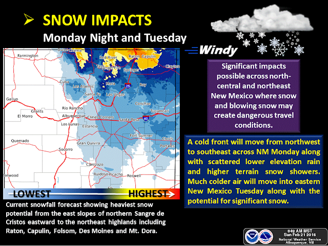
Northern and northeastern New Mexico are currently forecast to receive the brunt of this next storms heaviest snows. Several of the models have up to or close to a foot of snow falling across the northeastern third of the state including the Raton area. If the Canadian model (see graphic above) is correct with its snowfall forecast then accumulating snows may fall as far south as the Tatum area by Tuesday night. Both the Canadian and the WPC models have snow falling over most of southeastern New Mexico but not accumulating by Tuesday night. Most of the local area will only see afternoon highs in the mid 30's to mid 40's Tuesday if the Canadian is correct.
Believe it or not but a few isolated thunderstorms may approaching or become marginally severe Monday afternoon and evening. Low level southeasterly upslope flow is forecast to return to the area on Monday and deepen Monday night. Good lift and dynamics aloft ahead of the approaching cold front and upper level storm will provide an unstable atmosphere over southeastern New Mexico and parts of West Texas. Thunderstorms will be possible and capable of producing hail, gusty winds, and dangerous cloud to ground lightning.
The Truth Is Stranger Than Fiction!


Comments
Post a Comment
Your comments, questions, and feedback on this post/web page are welcome.