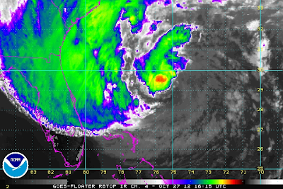
Hurricane Sandy May Threaten 60+ Million People!
At 10:15 AM MDT Saturday October 27, 2012.
At 9:45 AM MDT Saturday October 27, 2012.
Hurricane Sandy was located about 355 miles southeast of Charleston, South Carolina as of 9 AM MDT this morning. She continues moving off to the north-northeast at around 9 mph. Her central pressure is down to 28.29 inches of mercury, or 958 millibars.
Model Forecasts Of Sandy's Track.
00Z/6 PM MDT European (ECMWF) Forecast.
Valid At 6 PM MDT Monday October 29, 2012.
00Z/6 PM MDT Canadian (CMC) Forecast.
Valid At 6 PM MDT Monday October 29, 2012.
06Z/Midnight MDT U.S. NAVY NOGAPS Forecast.
Valid At Noon MDT Monday October 29, 2012.
12Z/6 AM MDT U.S. GFS Forecast.
Valid At 6 PM MDT Monday October 29, 2012.
12Z/6 AM MDT NCEP NAM 10-Meter Forecast.
Valid At 3 PM MDT Monday October 29, 2012.
12Z/6 AM MDT NCEP NAM 4KM Forecast.
Valid At Noon MDT Monday October 29, 2012.
Snowfall Totals Valid At 6 PM MDT Wednesday Oct 31, 2012.
There currently are no meteorological precedents for Hurricane Sandy, which will eventually morph into a hybrid monster once she makes landfall. The weather world is burning down with discussions, blogs, new stories, and chatter about where, and what will Sandy do to the Eastern U.S. Seaboard and nearby areas.
History could be re-written with this one. Some 60+ million people may be affected. Power could be out in many of these areas for weeks, which as crazy as it sounds, could potentially affect the upcoming election. Damages from Sandy could potentially exceed $1 Billion.
Some model forecasts indicate that Sandy may dump up to 12"-15" of rain before she finally dissipates later next week. Inland, heavy snow (maybe more than 2 feet worth) could pile up in parts of the Appalachian Mountains of West Virginia.
I thought I would do something different, and provide you with some useful links that will help inform you of the many dangers this potentially historic storm posses. No doubt, once Sandy nears the coastal areas somewhere from New Jersey to New York, and makes landfall, her main initial impacts will include the following-
Very heavy rainfall, flooding, flash flooding, high winds (which may be sustained at 80-100 mph), coastal flooding, flooding from storm surges and high tides, downed trees, and downed power lines. No doubt beach erosion and structural damages may be widespread.
Links To Discussions Of Sandy's Potential Impacts-
The Truth Is Stranger Than Fiction!
My Web Page Is Best Viewed With Google Chrome.


Comments
Post a Comment
Your comments, questions, and feedback on this post/web page are welcome.